Tag Archives: tornado

2019 has been a historical year for tornadoes

The United States has gone through a relative lull in tornado activity for the last six years. Starting in 2012, the number of tornadoes compared to historical data has been below average, as well as the number of violent EF-4 and EF-5 tornadoes. The numbers have likely even dropped more because there were fewer people distributed in Dixie Alley and Tornado Alley to witness tornadoes. Additionally, tornadoes couldn’t be confirmed via Doppler radar like today, and it was harder to determine if a tornado was a single track storm (one tornado) that skipped up and down or multiple, discrete tornadoes that formed from the same cell, or different ones.

If you’ve been following the weather news, 2019 has been historical with the longest continuous tornado outbreak in US history. There have been more tornadoes in a shorter period. The April 2-3, 1974 Super Outbreak produced 143 tornadoes in 24 hours, including multiple EF-5 tornadoes. In one case several communities in Alabama were hit with multiple EF-5 tornadoes within 90 minutes. More recently was April 27, 2011, Super Outbreak that produced 173 tornadoes, in the same Dixie Alley region of the 1974 outbreak.

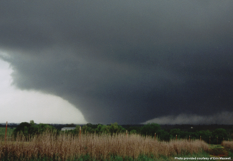
There have been more powerful tornadoes than the ones produced such as the 2013 El Reno tornado that killed Tim Samaras and his son and the 2011 Joplin EF-5 tornado that killed 161 people. This current outbreak has not produced any EF-5 storms (although the potential has been there) as of this writing.

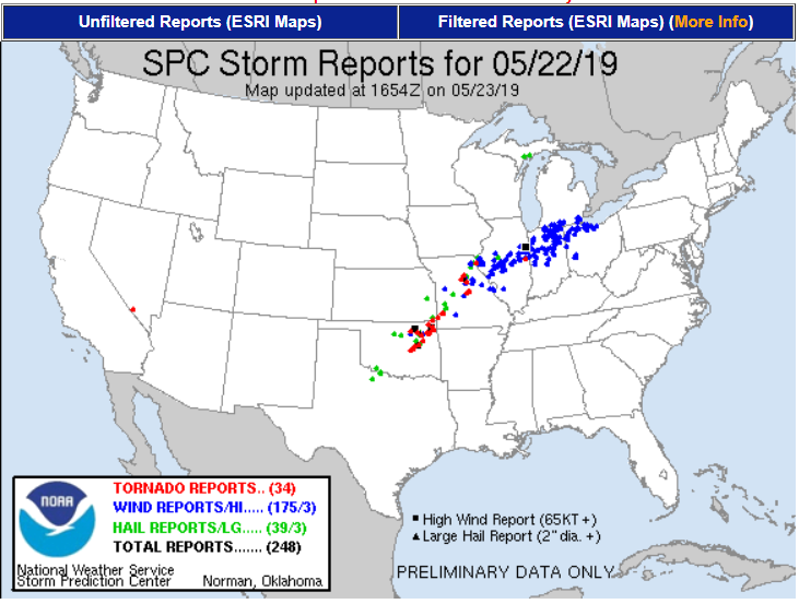
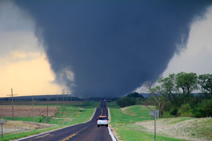
What has been unique about 2019 is the duration of this outbreak, 13 days and counting as I type this, and the streak of “outbreak” will likely continue. During this period, the United States has averaged a bit more than 27 tornadoes a day. The distribution of these supercells has been wide, with tornadoes striking as far west as Oklahoma, as far south as Alabama, and as far north/east as Pennsylvania. Even New York City received a tornado warning for Doppler confirmed rotation (no touchdown apparent).

The weather is not climate, and the climate is not the weather. There are a lot of theories on “why” things were quiet for the last six years and to why things have been so violent this year, but nothing solid. As much as we understand about our world, deep scientific understanding of tornado development and strength remains a mystery. Why do some supercells produce monstrously destructive EF-5 twisters, while other cells with the same potential energy, the same mechanics, and the same development do not?

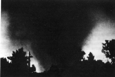
What has been unique this year is a deeply entrenched weather pattern of hot, humid air over the southeast, including historical heat, and cold, dry air to the north. This weather pattern is classic for severe weather development but usually appears for one to three days. The high pressure and low-pressure areas move along the frontal boundaries, and the pattern dissolves — June of 1953 provides a great example of how these weather patterns usual move. On June 8, 1953, an F-5 tornado tore through Flint, Michigan, killing 116 people. On June 9, 1953, the same weather system produced an F-4 tornado that ripped through Worcester, Massachusetts. That is a distance of about 800 miles over 24 hours. June 10, 1953, was a perfect day in Worcester as the cold front passed through, and brought drier, cooler air behind it.

In 1953 there was a lot of rumor and myth about why these massive tornadoes formed in areas where tornadoes of this strength haven’t been seen. Nuclear bomb testing, weather control tests gone awry, and that the Flint and Worcester tornado was the “same storm” that traveled 800 miles. None of this was true as the weather is not climate and the climate is not the weather.

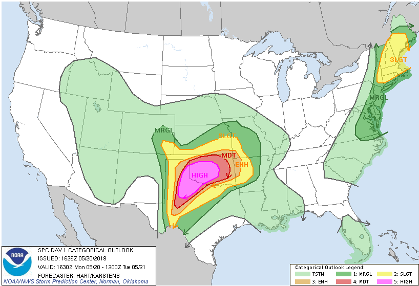
For now, the current weather pattern that is creating an extended dry line with limited cap, strong shear, and some stunning MCAPE numbers (geek speak for the ingredients for tornado development) looks to linger over the United States for days – long range models are like throwing darts but for now it could be weeks. If you live east of the Rockies should keep your eyes on the sky and be prepared, oh, and calling in death threats to TV stations and weather reporters for providing breaking news on tornado warnings? What the fuck America?

Malcontent, out.

Significant tornado slams Jefferson, Missouri

Update: Since this was written many photographs and videos of the damage in Jefferson have appeared. The storm appears to be a very strong EF-3 from the photos. This is my personal, unofficial evaluation using the Enhanced Fujita Scale information linked below.

The slow-motion weather system that has exacerbated historic levels of flooding on the Arkansas, Missouri, and Mississippi Rivers continues to produce devastating tornadoes. Although the initial outbreak earlier this week was surprisingly tepid for the conditions, tornadoes continue to be produced, including a storm near Joplin, Mississippi that killed three last night. It was Jefferson, Missouri in the bullseye last night.

As of this writing, the tornado that struck Jefferson has produced no fatalities, but rescue operations are still ongoing. Interestingly, our always-connected age likely saved many lives compared to 30 years ago, when the timing of this twister could have been catastrophic. Strong tornadoes during nighttime hours are not unprecedented, but they are rarer. Atmospheric and surface warming produced by the sun is a core ingredient to creating the lift needed to build supercells – but it does happen. The Jefferson tornado was around 11:30 PM with the first 911 calls coming in at 11:39 PM. Tornado sirens sounded, news broadcasters advised move to basements and cellphones alerted.

Thirty-four tornadoes touched down on 5/22/19 along the frontal boundary from Oklahoma to Illinois.

Tornadoes are dangerous, but nighttime tornadoes present special hazards. Tornadoes that tear through residential areas hit when most people are home, creating a higher risk for injury and death. Tornadoes can be hard to see when rain wrapped or shrouded in low clouds, but they are impossible to see at night. Sleeping people aren’t aware of warnings and can’t take early action. Warnings can be shorter because there is no physical observation and rely on radar detection. Outside of advanced warning, you won’t know a tornado is upon you until you hear the telltale roar, see the vivid near-continuous lightning, and the start of debris pelting your home. After the tornado passes, self-evaluation is fraught with hazard from debris and potentially downed live powerlines. In the most severe outbreaks, where storms “train” that is one cell follows one after another in the same path, another tornadic system can be following behind.

Many of the trapped received and heeded the warnings moving to the basements of their homes. When their homes collapsed, they became trapped required extraction. There is a lesson here in Puget Sound where the “big one” (e.g., earthquake) would hit without warning. If your survival kit is in the lowest part of your house, there should be at least some tools to get to your survival kit somewhere else and with your survival kit.

Tornadic activity will continue, along with flash flooding and historic water levels that are crushing records along three major rivers. The tornado activity is business as usual for this time of the year, and there have been much larger outbreaks. Given all of the energy in this system, it is a bit of a surprise that so far, no EF-4 or EF-5 storms have formed. Looking at the pictures from Jefferson, Missouri, this appears to be a strong EF-2 or middling EF-3 tornado that struck – but admitted the pictures taken in low light don’t show enough area-wide damage to make a proper armchair Enhanced Fujita Scale evaluation.

Tornado outbreak expected today

It is going to be a rough day in northern Texas and central Oklahoma. Conditions have lined up to create the first High Risk warning from the Storm Prediction Center in two years. As I often write, the weather is not climate; the climate is not the weather. The geography and intensity of this forecast are not out of the “norm,” despite High Risk warnings being rare. For the heart of Oklahoma and part of the Texas panhandle, there is a 45% chance of a tornado forming today, and a better than 10% chance that any given tornado will be EF-2 or stronger. In plain English, that means if you live in Oklahoma City, there is a 45% chance today that a tornado will touch the ground within 25 miles of where you are sitting. There is a 10% chance that tornado will be EF-2 or stronger. That kind of odds schools close and businesses send people home.

Tornado-producing supercells need several things to form. They need energy, and that comes in the form of high humidity. Dew points in the area are in the 70s, which is ridiculously high humidity. That is the kind of humidity where you walk out of the house, and your clothes stick to your body two minutes later. You need convection, you need high temperatures, and you can’t have a “cap,” that is a temperature inversion that traps warm air close to the surface. Finally, you need wind shear, that is the wind at different altitudes traveling in different directions, and you need a lot of wind shear. High dew points and unstable air can create amazing thunderstorms, but it is the wind shear that turns them into rotating supercells. There is one other element that enhances the development of tornadic producing storms, individual cell development. Thunderstorms that form in a line along a front can produce tornadoes, but the mechanics (which I’ll spare here) of the storms combine and act to moderate supercell and tornadic development within the cells. It is the stand-alone cells with a forecast model like today, that can form and produce the largest tornadoes.

Tornado damage is measured using the Enhanced Fujita scale. Tetsuya Fujita and Allen Pearson developed the Fujita scale to measure the strength of tornadoes consistently and started using the scale in 1971. It was updated in 1973 and 2007 when it became the Enhanced Fujita Scale.  The scale goes from EF-0 to EF-5. An EF-0 can raise your blood pressure, break large branches off a tree, take some shingles off the roof, crack some windows, and send the trash cans into the neighbor’s yard. An EF-5 can suck the pavement off of the ground, toss loaded rail cars like children’s toys, and leave nothing but a concrete slab behind when it passes over a house. The 1996 movie Twister may be loaded with pseudoscience and hyperbole, but the description of an EF-5 tornado as, “the finger of God,” is correct. As a civilian, there are only three ways to escape an EF-5, get out of its a path (never attempt to outrun a tornado), go underground, be in a specialized tornado shelter built to survive an EF-5 — the end.  

Storm Prediction Center Convective Outlook for May 20, 2019

In addition to the extreme danger in the central Midwest, there is a more than a small chance for tornadoes in most of Connecticut, western and central Massachusetts, almost all of New Hampshire and the western part of Maine. This too isn’t an “unusual,” forecast for this time of the year. You might be surprised to learn that Massachusetts suffered one of the most destructive tornadoes in United States history in 1953. There remains debate among scientists if the Great Worcester Tornado was an EF-4 or EF-5 storm, and the damage has gone through an unprecedented review twice. For today the storm stands as a very strong EF-4.

The Great Worcester Tornado in 1953, taken as it reached EF-3 strength in Holden, Massachusetts

Although watches, warnings, and forecast models have gotten much better, and research has gotten more extreme, the average warning times for tornadoes remains excruciatingly short. Yesterday, in a real-life Twister not based on Hollywood fantasy (I’m harsh, it is easy to call out everything the movie Twister got wrong, but it did get a lot right) Reed Timmer was able to drive his Dominator 3 vehicle into a tornado and get 3 drones deployed. As much as we may understand our world, we still don’t fully understand the mechanics of why some supercells produce tornadoes and others don’t. The more we can learn, the better we can understand what a tornadic supercell looks like in early development, and the earlier we can issue warnings. For that part, the movie Twister got 100% right. Stay safe out there, and if you live in one of these areas under an Enhanced, Moderate, or High Risk categorical forecast, keep your eye to the sky and have your survival plan in place.