Category Archives: Terra Firma

Another round of record-setting heat is coming this week

The headline says it all. We have a classic thermal trough setting up on Tuesday, we cook on Wednesday, and the heat falls apart on Thursday. We started June slightly warmer than normal (two outlier days that were very below normal) and with a typical, June Gloom, pattern. There is almost no chance for rain in the next 10 days (anything past 5 days is throwing darts). There is a tiny chance of some drizzle on Friday right now, but even that is too far off to predict with confidence.

Let’s start with Tuesday. Winds will pick up and be out of the north but then die out around midday. Kirkland is looking at a high of 80 to 83, depending on your location. High hills and right along the water, think 80 degrees, Totem Lake, our hot spot, 83. Tuesday night we will only get down to 60 degrees with a blanket of clouds moving in.

Wednesday is a little complicated. The models are calling for clouds to hold for most of the day and little wind, so this is a weak thermal trough. We’re looking at record-setting temperatures of 86 to 90 degrees in Kirkland. At Seattle-Tacoma International Airport (KSEA) the official weather forecast is a high of 89 degrees. This would break the previous record of 85. As I’ve written in the past, the computer models don’t do a good job of capturing the impact of thermal troughs in the forecast and usually predict 2 degrees lower than actual, so right now, I’m pretty confident we will see our first “official” 90-degree day on Wednesday. If we get a little more east wind, or the clouds break up sooner, we’ll be hotter. If the cloud blanket is thicker than the models indicate, we’ll be cooler. Stay tuned.

Thursday the thermal trough moves east, but Kirkland will still hit 80 to 83 degrees with a near copy of Tuesday. Friday the winds shift to the west, northwest again and the marine air pushes back in. That gives us our very slight chance for some morning drizzle on Friday, but nothing that will move the needle on our growing rainfall deficit.

Please remember for the heat:

  • You can still get sunburned on a cloudy day. Wear your damn sunscreen because Seattle is practically the skin cancer capital of the United States.
  • Don’t leave your pets in your car. No having the window open isn’t enough. No, I just went in for five minutes doesn’t cut it. On a 90 degree day, the inside of your car can soar to 130 or 140 degrees in minutes. That is death, a horrible, awful death.
  • I shouldn’t have to say don’t leave your kids in the car — I really shouldn’t have to.
  • I shouldn’t have to say don’t throw your cigarette butts out the window when you drive because they can start a fire when the air is dry and warm, but it needs repeating.
  • Area lakes and rivers are still dangerously cold. Please have a talk with your teens if they have swimming, river floats, or boating plans. Jumping into water under 50 degrees can cause a gasp reflex you can’t control, inhale a big mouthful of water, and that’s it. It happens every year, and it has already happened in 2019. These are senseless, preventable deaths.

Stay cool eastside!
Rain of the scarecrow

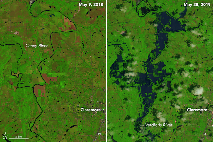
United States farmers are facing the worst crisis since the 1980s Soviet grain embargo. Although weather played a factor in the 1980s, the weather is a leading role in 2019. After years of drought impacting much of the country, the nation is now awash in water. Historical amounts of rain have created historic flooding, both in duration and ferocity, devastating farm operations across the United States.

In the first quarter of 2019, 160 farms filed for Chapter 12 bankruptcy, which would put 2019 for 600 plus filings, a 29% increase from last year. The total number of farms in the United States has been in steady decline since 2007, dropping about 10% in 11 years (statistics go to 2018). Total land use for farming in the United States has also declined during the same period, dropping about 5%.

Crop failures in the United States are at the worst levels in 30 years, and in many cases, it is because arable land is underwater, or too soaked to plant. Generally, at this time of the year, 79% of the cropland dedicated to soybean production would be planted – today it stands at 39%. For corn, the average would be 96% – today it is less than 65%. Farmers are facing a now or never choice this week across the nation. File crop insurance claims for, “prevented to plant,” and accept about 50 cents on the dollar on what would already be meager profits for doing nothing, or roll the dice and plant anyway. If they plant and the crops don’t provide a yield, they could file for federal aid or insurance. That assumes that the farmer has coverage in the first place.

Soil moisture levels were already at saturation for much of the eastern US by February, 2019

This crisis has been years in the making through a combination of climate change, market conditions, and the political landscape. In the 2000s, ethanol became mandated in US gasoline. Small ethanol producers were bought up by large corporations, and farmers shifted to corn to sell to the ethanol industry. The shifting of corn to ethanol production reduced the overall supply of other grains and raised the cost of feedstock for farm animals. The demand for beef and pork dropped due to rising prices. At the same time, rBST was sending milk production through the roof, creating an oversupply. Dairy farmers sent their herds to slaughter and gave up, while pork and beef producers sent their animals to market at a younger age.

Flooding in Nebraska impacted military operations at Offutt AFB in March, 2019

Fast forward a few years later, and with smaller dairy and livestock herds, demand for grains for feedstock plummeted creating a vast oversupply. The price of corn, soy, and wheat collapsed, gutting the profits reaped earlier this decade. The Obama Administration block the planned E15 ethanol mandate for all US gasoline, and the Trump Administration continues to block the rule. The expected increase in ethanol production never happened, adding to more oversupply and further depressing prices.

Add in a buying embargo by China for US soybeans, tariffs, a global oversupply of milk and milk products, US farmers were already reeling. Congress playing a game of chicken for disaster aid didn’t help matters, and the heartland of the United States will inevitably need more support going forward.

The weather patterns producing this historical rain event have eased, but there is still a tremendous amount of water that needs to flow through these river basins for weeks to come. All of this spells bad news for Louisiana, where the increased freshwater flow will accelerate land loss in the Mississippi Delta, and hurt oyster farms and harvesters. The decrease in salinity in the gulf lowers oyster yields.

Coming up next on the list of impacted agriculture from 2019 flooding, Gulf of Mexico oyster producers and harvesters

As for the ongoing flooding, in some cases, entire farms and communities have likely been lost forever. The tangle of levees in many of these regions is managed by independent cooperatives and local governments, which don’t have the money or resources to update or maintain them. The Army Corps of Engineers has already channeled and tamed the Arkansas, Missouri, and Mississippi Rivers, so there is little left they can do beyond build dams and levees they manage higher. Once a levee is overtopped, the flow of the water eats away it, requiring major repair, if not a full replacement. If a levee blows out at a middle point, the rushing water chews away at both sides. In many cases, the strategy is to wait for the rain to stop and wait for the water to recede – that could still be months away in some places.

As for the average American, in the short term, you can expect lower prices at your grocery store for some commodities that aren’t Heche en Mexico. Later this year as the full impact of the crop failures are felt, prices will likely go up. Corn plays a huge role in the American food chain, as a feedstock for farm animals that impacts meat, egg and dairy prices, as a grain for cereals, and for corn syrup production as a sweetener. It also will likely increase costs at the pump (more likely it will blunt the slow decline we start to see after the Fourth of July holiday weekend), with the gasoline you put in your car requiring 10% Ethanol content per federal law.

Copyrights 2008 Mario R. Duran (mariordo@aol.com).Release under Creative Commons Attribution – Wikipedia Creative Commons

The impact of climate change continues to play out as predicted in models that go back to the 1980s. The weather is not climate, and the climate is not the weather. Single weather events don’t serve as proof a change to this planet, but when taken together in aggregate, it is evident something is wrong.

Think about it.

Malcontent, out.

2019 has been a historical year for tornadoes

The United States has gone through a relative lull in tornado activity for the last six years. Starting in 2012, the number of tornadoes compared to historical data has been below average, as well as the number of violent EF-4 and EF-5 tornadoes. The numbers have likely even dropped more because there were fewer people distributed in Dixie Alley and Tornado Alley to witness tornadoes. Additionally, tornadoes couldn’t be confirmed via Doppler radar like today, and it was harder to determine if a tornado was a single track storm (one tornado) that skipped up and down or multiple, discrete tornadoes that formed from the same cell, or different ones.

If you’ve been following the weather news, 2019 has been historical with the longest continuous tornado outbreak in US history. There have been more tornadoes in a shorter period. The April 2-3, 1974 Super Outbreak produced 143 tornadoes in 24 hours, including multiple EF-5 tornadoes. In one case several communities in Alabama were hit with multiple EF-5 tornadoes within 90 minutes. More recently was April 27, 2011, Super Outbreak that produced 173 tornadoes, in the same Dixie Alley region of the 1974 outbreak.

There have been more powerful tornadoes than the ones produced such as the 2013 El Reno tornado that killed Tim Samaras and his son and the 2011 Joplin EF-5 tornado that killed 161 people. This current outbreak has not produced any EF-5 storms (although the potential has been there) as of this writing.

What has been unique about 2019 is the duration of this outbreak, 13 days and counting as I type this, and the streak of “outbreak” will likely continue. During this period, the United States has averaged a bit more than 27 tornadoes a day. The distribution of these supercells has been wide, with tornadoes striking as far west as Oklahoma, as far south as Alabama, and as far north/east as Pennsylvania. Even New York City received a tornado warning for Doppler confirmed rotation (no touchdown apparent).

The weather is not climate, and the climate is not the weather. There are a lot of theories on “why” things were quiet for the last six years and to why things have been so violent this year, but nothing solid. As much as we understand about our world, deep scientific understanding of tornado development and strength remains a mystery. Why do some supercells produce monstrously destructive EF-5 twisters, while other cells with the same potential energy, the same mechanics, and the same development do not?

What has been unique this year is a deeply entrenched weather pattern of hot, humid air over the southeast, including historical heat, and cold, dry air to the north. This weather pattern is classic for severe weather development but usually appears for one to three days. The high pressure and low-pressure areas move along the frontal boundaries, and the pattern dissolves — June of 1953 provides a great example of how these weather patterns usual move. On June 8, 1953, an F-5 tornado tore through Flint, Michigan, killing 116 people. On June 9, 1953, the same weather system produced an F-4 tornado that ripped through Worcester, Massachusetts. That is a distance of about 800 miles over 24 hours. June 10, 1953, was a perfect day in Worcester as the cold front passed through, and brought drier, cooler air behind it.

In 1953 there was a lot of rumor and myth about why these massive tornadoes formed in areas where tornadoes of this strength haven’t been seen. Nuclear bomb testing, weather control tests gone awry, and that the Flint and Worcester tornado was the “same storm” that traveled 800 miles. None of this was true as the weather is not climate and the climate is not the weather.

For now, the current weather pattern that is creating an extended dry line with limited cap, strong shear, and some stunning MCAPE numbers (geek speak for the ingredients for tornado development) looks to linger over the United States for days – long range models are like throwing darts but for now it could be weeks. If you live east of the Rockies should keep your eyes on the sky and be prepared, oh, and calling in death threats to TV stations and weather reporters for providing breaking news on tornado warnings? What the fuck America?

Malcontent, out.

Significant tornado slams Jefferson, Missouri

Update: Since this was written many photographs and videos of the damage in Jefferson have appeared. The storm appears to be a very strong EF-3 from the photos. This is my personal, unofficial evaluation using the Enhanced Fujita Scale information linked below.

The slow-motion weather system that has exacerbated historic levels of flooding on the Arkansas, Missouri, and Mississippi Rivers continues to produce devastating tornadoes. Although the initial outbreak earlier this week was surprisingly tepid for the conditions, tornadoes continue to be produced, including a storm near Joplin, Mississippi that killed three last night. It was Jefferson, Missouri in the bullseye last night.

As of this writing, the tornado that struck Jefferson has produced no fatalities, but rescue operations are still ongoing. Interestingly, our always-connected age likely saved many lives compared to 30 years ago, when the timing of this twister could have been catastrophic. Strong tornadoes during nighttime hours are not unprecedented, but they are rarer. Atmospheric and surface warming produced by the sun is a core ingredient to creating the lift needed to build supercells – but it does happen. The Jefferson tornado was around 11:30 PM with the first 911 calls coming in at 11:39 PM. Tornado sirens sounded, news broadcasters advised move to basements and cellphones alerted.

Thirty-four tornadoes touched down on 5/22/19 along the frontal boundary from Oklahoma to Illinois.

Tornadoes are dangerous, but nighttime tornadoes present special hazards. Tornadoes that tear through residential areas hit when most people are home, creating a higher risk for injury and death. Tornadoes can be hard to see when rain wrapped or shrouded in low clouds, but they are impossible to see at night. Sleeping people aren’t aware of warnings and can’t take early action. Warnings can be shorter because there is no physical observation and rely on radar detection. Outside of advanced warning, you won’t know a tornado is upon you until you hear the telltale roar, see the vivid near-continuous lightning, and the start of debris pelting your home. After the tornado passes, self-evaluation is fraught with hazard from debris and potentially downed live powerlines. In the most severe outbreaks, where storms “train” that is one cell follows one after another in the same path, another tornadic system can be following behind.

Many of the trapped received and heeded the warnings moving to the basements of their homes. When their homes collapsed, they became trapped required extraction. There is a lesson here in Puget Sound where the “big one” (e.g., earthquake) would hit without warning. If your survival kit is in the lowest part of your house, there should be at least some tools to get to your survival kit somewhere else and with your survival kit.

Tornadic activity will continue, along with flash flooding and historic water levels that are crushing records along three major rivers. The tornado activity is business as usual for this time of the year, and there have been much larger outbreaks. Given all of the energy in this system, it is a bit of a surprise that so far, no EF-4 or EF-5 storms have formed. Looking at the pictures from Jefferson, Missouri, this appears to be a strong EF-2 or middling EF-3 tornado that struck – but admitted the pictures taken in low light don’t show enough area-wide damage to make a proper armchair Enhanced Fujita Scale evaluation.

2018 was the wettest year in U.S. history

Eighteen months ago almost 40% of the nation was gripped in drought, much of it severe. California appeared to be drying up, the large lake projects of the desert southwest were at historic lows, Texas and the southeast was turning into dust until historic tropical rainfalls created 24-hour records across the region.

As I type this today, only 3% of the United States is in drought (and most of Washington state is in the exceptionally dry to drought category). California got 21 Pineapple Express storms this past winter, obliterating drought conditions. The southeast and southwest were pummelled by tropical rains, the Midwest is facing historic flooding, and the northeast was kind of normal.

The weather is not climate and climate is not the weather. Oh wait a minute, this wasn’t weather, this was a continental trend which is more related to climate. The predicted models that go back to the 1970s continue to play out and at an accelerating rate.

As for the Pacific Northwest, El Nino conditions should continue through the summer, and we’re already behind on rainfall. Look for worsening drought conditions through the summer, including the lowlands. A good example of the weather is not climate and the climate is not the weather. Hey, we’re in a drought! I thought global warming would mean more rain??? Ya, for the other 97% of the country people are saying, “please make it stop.”

As I’ve recommended in Happy Hour last week if you’re a gardener/farmer planting your last starts and your annuals, target drought-resistant strains and vegetables that do well in a dryer, hotter climate. Also with the Golfer-in-Chief slapping tariffs on Mexican tomatoes and prices expected to nearly double (along with the fact that Florida tomatoes need to make a much longer trip to get to Washington state and taste like cardboard) this is a good year to plant them tomatoes and just grow them yourself.

You can read the Category 6 blog at the Weather Underground for more information.

Get prepared for summer smoke now

TL;DR

  1. Growing evidence that our climate is changing
  2. Puget Sound now has some of the worst air in the country
  3. Summer is coming and with it likely more wildfires
  4. You should prepare now
  5. Particulate matter is horrible for your lungs, and you don’t realize you damaged your lungs until it is too late
  6. N-95 masks help and don’t make you look like a dork, but don’t help everyone
  7. Consider creating a clean air space in your home
  8. This sucks

Climate is not the weather.

The weather is not climate.

Weather patterns are changing globally. When looked at as a whole, there is a growing body of evidence that these changes, which started hand-in-hand with the Industrial Revolution, are resulting in climate change.

The Arctic regions have seen one of the biggest shifts with extreme warm spells, shrinking glaciers, ice sheets, and seaside communities washing into the ocean. Permafrost frozen for more than 40,000 years is become less – permanent. In other regions, like the lower 48 of the United States, the changes are more subtle. Earlier springs, longer falls, increased rainfall when it rains, longer dry spells when there is drought. Here in Puget Sound, a growing addition to this change is smoke.

It is with a hardy and sarcastic, “congratulations,” Puget Sound now has some of the worst air in the United States. Those bluest skies I’ve ever seen as in the song have turned increasingly hazy, and over the past two summers, toxic. Most of this change is due to wildfires that have surrounded our region. Prevailing winds blow the smoke into the Puget Sound region where it gets trapped. The only thing that pushes it out is marine air off the coast, which then turns our skies gray with clouds and drops the temperature into the 60s and low 70s. Our spectacular Augusts replaced by days of 90 plus degrees with orange skies and the smell of burning forests or 65 degree days with drizzle and low gray clouds – but on those days we can breathe.

The reasons for the fires are more complex than weather events or a shift in climate. Poor forest management, increased human activity in forested areas, communities expanding into forests and grasslands, and an increase in “dry thunderstorms,” has conspired to generate more fires. The longer growing seasons, which are weather related, generate more fuel, while hotter summers dry out that fuel faster.

The ironic part is the smoke moves more people to motorized transit, which increases traffic, which creates more pollution, which makes it worse – but the pollution created by vehicles is not the particulate matter created by wildfires. The engineered congestion in Puget Sound creates lung congestion on our worst days.

Our declining air quality due to climate change and forest management isn’t just a Terra Firma Thursday issue; this is also a Weighty Matters issue. In other parts of the world, it isn’t just common, but it is socially acceptable to wear masks when sick or when pollution is severe. In the United States, this is met mostly with snickers.

The fine particulates that turn our skies orange in the summer are terrible for your lungs. The particulates accumulate, that is get trapped inside your lungs, and over time permanently damage your lung capacity. This decrease in capacity is insidious as it happens gradually and over the years. Of all the functions in our bodies, lungs go the longest before revealing to us there is a real issue – and then it is too late to reverse the damage.

As we start to approach summer, with another long-range forecast model of, “hotter and dryer than the norm,” now is the time to get prepared.

  • Get some N-95 masks. When the smoke starts, they’ll become more difficult to find. You can buy them online from many websites including Amazon, Home Depot, and Lowes. Remember, N-95 masks only work when tightly fitted to the face. Small children and those with facial hair can’t use them. Additionally, N-95 masks are not designed to be worn for days on end. Which means you need to limit your overall exposure when the smoke is bad.
  • Surgical masks don’t block fine particulates, they don’t work.
  • Our smoky days typically go hand-in-hand with our hottest days. In 2018 we had several days that would have been record-shattering, 100 degrees plus, but the smoke kept our temperatures down 3 to 6 degrees in the high 90s. Ideally, on the worst days, you should keep your windows closed. Now is the time to consider a portable air conditioner for at least one room, to create a clean air space in your home.
  • Along with a room with AC, having a box fan with a furnace filter taped to the “intake” side (the side that pulls the air) has been shown to dramatically reduce particulate matter in the air. If you can’t afford an AC, a $20 box fan and a $10 filter can significantly improve air quality in a single room. Ideally, if possible, you should do both.
A furnace filter duct taped to a box fan is a low cost way to clean the air in a single room.

  • When you drive your car run your AC and run it in the “max” or “recirculation” mode. This recycles the air within your cabin. If your car doesn’t have working AC, you’ll need to wear an N-95 mask when driving.
  • On the worst smoky days don’t do outdoor activity if you can. If you work outdoors, your employer should provide N-95 masks. This is vital on days where there is ash fall.
  • Exercise should be done indoors in a climate controlled setting. If you have medical issues, to begin with, avoid exercise or better yet, talk to your doctor.
  • Contact wearers should make sure now that their glasses prescription is up to snuff. On the worst days, you’ll want to rip your eyeballs out when you’re wearing contacts.
  • Ash is very alkaline and damaging to car paint. Additionally, ash can create spiderweb scratches in auto finishes. On days with bad ashfall consider rinsing your car off with a hose. Smoke is generally not as bad during the morning hours as we get some marine air trying to push in. If it is down to your lungs or your car paint, you should choose the lungs.
  • Welcome to the new normal.