Tag Archives: climate change

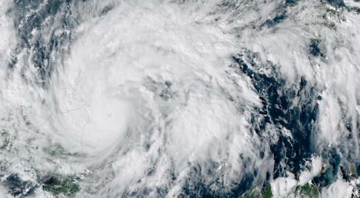
Historic Hurricane Eta sets sights on Nicaragua

Hurricane Eta is the 28th named storm of the 2020 Atlantic Hurricane season, tying the record for the most named storms in a single season. At 10:00 AM PST, Eta was 85 miles from the Nicaragua-Honduras border with winds of 120 MPH and heading west at 9 MPH. Forecasted predict that when Eta makes landfall near Puerto Cabezas in Nicaragua, Eta will be a Category IV storm with winds of 140 MPH, a storm surge of 12 to 18 feet, and bringing as much as 35 inches of rain to the mountains of Nicaragua.

Nicaraguan officials order evacuations along the Caribbean coast of Nicaragua, a semi-autonomous zone with pockets of crushing poverty. Puerto Cabezas is home to 60,000 people, and officials have set up evacuation centers in churches and schools.

Forecasters, state officials, and humanitarian organizations are most concerned about the amount of rain Eta will bring to the region. With the hurricane expected to slow as it approaches Nicaragua, river and flash floods along with mudslides are of grave concern.

Nicaragua suffered more than 3,800 deaths when Hurricane Mitch made landfall in 1998, causing devastating flooding. It took the nation almost 15 years to rebuild infrastructure, and as recently as 2018, was considered a rising star of economic power. In April of 2018, civil unrest rocked Nicaragua when the Ortega regime slashed social security benefits. Widespread protests were met with a violent reaction by government irregular forces, armed militias, imprisonment, torture, and rape. Since the summer of 2018, global economic sanctions and travel advisors have destroyed the budding tourism industry.

Hurricane Eta is expected to cross Latin America and enter the Pacific Ocean later this week, creating the potential for a rare “cross over” hurricane. If Eta can regain tropical status, it would be only the 19th storm since 1842 to cross over and become, technically, a typhoon.
Hurricane Zeta makes landfall in Louisiana with 110 MPH winds

Hurricane Zeta strengthened significantly above forecasted models as a strong Category II storm with 110 MPH winds and higher gusts, making landfall in Cocodrie, Lousiana at 2:44 PM PDT. The compact storm has hurricane-force winds extending 35 miles from the center and was moving at 24 MPH. Evacuation orders along the Louisiana, Alabama, Mississippi, and Florida panhandle had been sparse based on forecast models, and officials now worried about thousands in harm’s way.

Hurricane Warnings, Tropical Storm Warnings, and Storm Surge Warnings have remained unchanged since Tuesday, extending from Mississippi to Florida. As of 2:00 PM PDT, Zeta was 65 miles south-southwest of New Orleans. Storm surge, responsible for most hurricane-related deaths, was forecasted to be 7 to 11 feet at the mouth of the Pearl River on the Mississippi-Alabama border, and 6 to 9 feet at Port Fourchon, located at the mouth of Mississippi River.

Zeta is the 11th named storm to make landfall in the continental United States, and the fifth system to hit Lousiana in 2020. The National Weather Service is tracking three tropical waves across the Atlantic, any of which could develop into the 28th named storm, Eta.

Zeta strikes Mexico, expected to return to hurricane strength

Hurricane Zeta made landfall along the northern tip of the Yucatan Peninsula in Mexico as a Category I storm with 80 MPH winds. Reports indicate minimal damage, with Zeta dropping 4 to 8 inches of rain before moving into the western Caribbean. The brush with land dropped the winds to 60 MPH, once again making Zeta a Tropical Storm, but restrengthening is expected with a collision course set for the Gulf Coast of the United States. 

The National Weather Service predicts Zeta will make landfall as a Category I hurricane with 80 MPH winds on Wednesday. Current projections indicate the eye of the storm projected to land between New Orleans, Louisiana, and Mobile, Alabama. Hurricane forecast is challenging, and residents from the Texas-Louisana border to Florida’s panhandle should be preparing.

Hurricane Warnings extend from Morgan City, Lousiana to the Mississippi-Alabama border. A Tropical Storm Warning extends from the Mississippi-Alabama border to the Klakoosa-Walton County line in Florida. A Storm Surge Warning stretches from the Atchafalaya River’s mouth to Navarre, Florida, and includes Lake Pontchartrain, Lake Borgne, Pensacola Bay, and Mobile Bay.

Hurricane Zeta will be historic, being the 11th named storm to make landfall in the United States during the 2020 hurricane season and the fifth tropical system to arrive in storm-battered Louisiana.

Zeta strengthens, Hurricane Watches for Louisiana and Alabama

Zeta strengthened to a Category I hurricane with 80 MPH as it continues its northwestward march toward the Yucatan Peninsula of Mexico. Officials in Cuba discontinued the Tropical Storm Warnings for the western part of the island nation as Zeta moved away. US officials issued a Hurricane Watch from Morgan City, Louisiana, to the Mississippi-Alabama border. The Hurricane Watch includes Lake Ponchitrain and New Orleans.

In Mexico, Hurricane Warnings include the island of Cozumel, battered three weeks ago by Hurricane Delta. Zeta is expected to pass over the Yucatan Peninsula Monday night, then emerge back into the Gulf of Mexico, where it will gather strength. Forecast models indicate that heavy rain from the system could be lashing the Gulf Coast of the United States by Tuesday night.

WDSU of New Orleans reports voluntary evacuation orders in Orleans Parish for those who live outside of the levees and in Jefferson Parish for all residents. Additionally, mandatory evacuation orders for all campers, RVs, and boat residents on Grand Isle. Zeta will be the 11th named system to make landfall on the United States in 2020, a record, and the fourth system to strike the Yucatan Peninsula. 

Historic Tropical Storm Zeta expected to become hurricane

Tropical Storm Zeta, the 27th named storm in the 2020 hurricane season, is churning in the Caribbean on a collision course with the Yucatan Peninsula.

The earliest 27th named storm in history, Zeta is expected to strengthen into a hurricane before making landfall Monday night or early Tuesday morning, local time. Zeta has sustained winds of 70 MPH, just under hurricane strength and moving northwest at 7 MPH. Hurricane warnings are posted along the northern tip of the Yucatan Peninsula, and Tropical Storm Warnings are posted in western Cuba.

Hurricane battered east Texas, Louisana, and Alabama are once again in the bullseye. With confidence growing, Zeta would be the 11th named storm to make landfall in the United States, with projections indicating the storm will arrive Wednesday evening. If Zeta makes landfall in the United States, it would be a record-setting eleventh tropical system to strike the United States in a single hurricane season.

Officials advise Louisiana residents to prepare for yet another tropical system, with storm surge, wind, and flooding rains.

2018 was the wettest year in U.S. history

Eighteen months ago almost 40% of the nation was gripped in drought, much of it severe. California appeared to be drying up, the large lake projects of the desert southwest were at historic lows, Texas and the southeast was turning into dust until historic tropical rainfalls created 24-hour records across the region.

As I type this today, only 3% of the United States is in drought (and most of Washington state is in the exceptionally dry to drought category). California got 21 Pineapple Express storms this past winter, obliterating drought conditions. The southeast and southwest were pummelled by tropical rains, the Midwest is facing historic flooding, and the northeast was kind of normal.

The weather is not climate and climate is not the weather. Oh wait a minute, this wasn’t weather, this was a continental trend which is more related to climate. The predicted models that go back to the 1970s continue to play out and at an accelerating rate.

As for the Pacific Northwest, El Nino conditions should continue through the summer, and we’re already behind on rainfall. Look for worsening drought conditions through the summer, including the lowlands. A good example of the weather is not climate and the climate is not the weather. Hey, we’re in a drought! I thought global warming would mean more rain??? Ya, for the other 97% of the country people are saying, “please make it stop.”

As I’ve recommended in Happy Hour last week if you’re a gardener/farmer planting your last starts and your annuals, target drought-resistant strains and vegetables that do well in a dryer, hotter climate. Also with the Golfer-in-Chief slapping tariffs on Mexican tomatoes and prices expected to nearly double (along with the fact that Florida tomatoes need to make a much longer trip to get to Washington state and taste like cardboard) this is a good year to plant them tomatoes and just grow them yourself.

You can read the Category 6 blog at the Weather Underground for more information.