Tag Archives: climate crisis

Here we go again, record-setting heatwave to sear Seattle a second time

[KIRKLAND, Wash.] – (MTN) The Seattle area is poised to break 100 degrees for the fourth time this summer, with a significant heatwave forecasted for the rest of the week. The National Weather Service issued an Excessive Heat Warning, including the Puget Sound Lowlands, from noon on Wednesday to 7 PM on Saturday.

A ridge of high pressure is building over the Pacific Ocean, bringing eyebrow-raising heat to our region, but not as hot as the record-shattering heatwave in June. Temperatures broke 100 degrees three days in a row earlier this year during a historic heatwave that shattered all-time temperature records from Alaska to California. 

In addition to the heat, Western Washington can expect some smoke to move into the region. High-pressure areas circulate counter-clockwise, which will pull smoke up from Southern Oregon and Northern California. Thursday and Friday are looking to be the worst days, but they won’t be like last year’s conditions. Most of it will be aloft, but some near-surface smoke is supported in the models. One other plot twist, the smoke is making Friday’s forecast pretty challenging.

Wednesday will start with partly cloudy skies and a low around 60 degrees F. in the Kirkland-Bellevue-Woodinville area. Temperatures will reach 87 to 90 degrees F. The usual hot spots of Totem Lake, Kingsgate, and the urban canyons of downtown Bellevue will likely get to the 90 degrees F. mark.

Wednesday night temperatures will drop to 62 to 64 degrees F. in our area. We’ll get a bit of offshore flow overnight, making it a bit uncomfortable, and pulling smoke into our region.

Thursday will see high temperatures from 95 to 98 degrees F. with increasingly hazy skies. The dewpoint will be around 60 degrees F., making it feel a little sticky. The air quality will decline to moderate with PM 2.5 in the 55 to 70 range. The record high is 96.

Thursday night will see high-altitude smoke continue to thicken, which will act as a blanket. Nighttime temperatures will be uncomfortable, with lows from 66 to 68 F. Winds will be near calm, with a slight offshore flow. As the air cools, some of that vertically integrated smoke will sink, and there isn’t much wind to circulate the air. The air quality will be moderate, with PM 2.5 in the 70 to 90 range.

Friday’s forecast is a tough call. The more smoke in the air, the more it will help lower high temperatures. The high-pressure area will continue to drive eastward, and the wind will shift to be more west-northwest during the day or early evening. High temperatures on Friday will be 97 to 100 degrees F. for the Kirkland-Bellevue-Woodinville area, which is 15 to 20 degrees above normal. If the smoke is thicker than the models indicate, shaving a few degrees from the high is possible. The air quality will be moderate, with PM 2.5 will be in the 55 to 70 range. I would expect to have the hazy orange glow we’ve seen a few times this year during the day. The record high is only 91 and is destined to be shattered.

Friday night won’t offer much relief again, but the smoke will begin to be pushed out. Lows will be 65 to 67 F. Air quality will be good to moderate, with PM 2.5 in the 40 to 60 range.

Saturday looks to be our fourth day in a row where the area will hit 90 degrees F. Highs will be 89 to 92, with clouds building in the afternoon as marine air pushes in from the coast. 

In June, we reached out to King County Health and other area experts to get advice on dealing with extreme heat. If you don’t have access to air conditioning, we can’t promise these tips will keep you from being miserable, but they will help keep you safe.

Historic drought sends lakes to record lows throughout the West

[OROVILLE, Cali] – (MTN) Lake Oroville is less than two feet above an all-time low while Lake Shasta is at its fourth-lowest level on record as historic drought grips the western United States. Lake Shasta continues to be shrouded in smoke from the Lava Fire, where the water sits 145 feet below full pool. At 921.93 feet above Sea Level, Shasta sits at about the same level it was in January 2016. Lake Oroville is at 646.63 feet, just 19 inches higher than a record set in 1977.

At Oroville, operators need to continue water flowing to support fisheries and farmers in the San Joaquin Valley that rely on water from the Sacramento River for irrigation. The river is already dealing with record high temperatures that have devested wild salmon, and the intrusion of saltwater upstream adding pressure to the ecosystem and farmers.

[Best_Wordpress_Gallery id=”61″ gal_title=”Historic Drought in the Southwest”]

The historic low levels have forced over 140 houseboats out of the lake, and only one temporary gravel boat ramp remains operations around the entire lake. Even that ramp is in danger of closing as the level is expected to continue to drop another 25 to 30 feet by October.

The Edward Hyatt Pump-Generating Plant is capable of generating 132 megawatts of power during peak operation. Although up to 17,000 cubic feet of water can flow through the plant per second, approximately 6,000 cubic feet can be recovered and pumped back into the lake. The outflow is captured in additional reservoirs to be sent into the Sacramento River basin and support the needs of farmers to the south. Under extreme conditions, water is sent out to the Yuba River. The water level is expected to reach what hydrologists call deadpool, and the hydro plant may have to close for the first time in its 53 year history.

Lake Shasta, outside of Redding, sits below the headwaters of the Sacramento River and also generates hydroelectricity.

To the north outside of Klamath Falls, over 300 homes have had their private wells run dry, leaving residents without water for farming and personal consumption. Demand for water delivery and drilling companies has driven up costs and lead time, while some communities are providing water at pickup points. Ranchers and homeowners are looking to drill deeper, but after twenty-two years of mostly drought-filled years, there are no assurances those wells won’t run dry.

In the Klamath, a perfect storm of climate change, overutilization, treaties with first nations, and too many promises by government officials have come to head. Some have resorted to stealing water from the district, with complaints of illegal marijuana farms in the area. In this hardscrabble area with an undertone of independence and anti-government sentiment, other operators are also taking water pitting neighbor against neighbor.

Tule Lake on the Oregon-California border is divided into four regions. The most visible at the beginning of the road to Lava Beds National Monument has been allowed to drain dry. The soil deeply cracked and baking under the relentless heat. In the early 1900s, Tule Lake was significantly drained to create the farmland that surrounds the area today. Operators elected to let the most visible part of the lake complex run dry, in an attempt to convert it into a more productive marshland when and if the water returns. Area residents are skeptical and some are complaining about dust and irritation coming from the evaporating mud puddle.

To the north Upper Klamath Lake is the largest freshwater body in Oregon. The shallow lake has suffered from declining water quality for decades, both from natural and manmade influences. In 2001, water was cut off from farmers by the Bush Administration to protect native suckerfish that are on the endangered species list and protect area salmon per First Nations treaties. The impact was devastating to farmers who depend, and hold contracts for water rights.

Upper Klamath Lake is shallow – just 8 feet on average and a maximum depth of 50 feet. Although the lake currently sits at 100% of the normal level today, it has been steadily declining since 2019. Increasing temperatures, agricultural runoff, and naturally occurring chemicals turn the lake green with algae blooms.

Farmers aren’t just facing a shortage of water, they are also facing a shortage of forage and feed for livestock. The cost of hay has skyrocketed adding additional pressure on the battered finances for the region. Tariffs, a reduction in international shipping, depressed prices, have forced some to send animals to market early, getting only pennies on the dollar for their efforts while costs keep going up.

In Utah and Arizona, fear and frustration are mounting at Lake Powell. The lake is only inches from setting a new historic low, beating the record set in 2005. Frustrated locals are growing increasingly angry.

Glen Canyon Dam is the second-largest hydroelectric generating facility in the Southwest, only behind Hoover Dam outside of Las Vegas. The dam generates 1,320 megawatts of electricity, enough to power 400,000 homes. Rapid population expansion in Arizona and Utah has driven up demand as the water level continues to decline. A shutoff of the outflow through the dam would cut off a critical electrical source increasing rates, and potentially plunging communities into darkness. Officials believe the water level at Lake Powell will continue to drop until the spring of 2022 and is dependent on significant snowfall in the Rockies to stage any kind of recovery.

Misinformation on the Internet also abounds with complaints that water is flowing out of Lake Powell and Lake Mead unnecessarily and out to the ocean in California. Both lakes are on the Colorado River, which reaches the Gulf of California in Mexico, where international agreements also require water for the nation on the United States border.

In Walla Walla, Washington, city officials have had to tap one of seven wells to supplement the city water supply. Under normal conditions, water would come from Mill Creek, but extreme drought coupled with extreme demand has forced the city to tap the backup supply. There is enough water in the reserves to supply the city for “several years,” according to officials. The area is known for its wine production. Some growers are reporting up to 50% of their crops were lost in a late June heatwave, that saw temperatures soar to 110 to 115 degrees F. This is the second hit in a row for grape producers who saw some of their harvests destroyed last year by “smoke taint” a growing concern as increasing smoke from wildfires in Washington and Oregon start to creep into the region.

In a cruel twist, a heavier than normal monsoon season has sent floods sweeping through parts of Utah and Arizona. The land has become so baked it can’t absorb the water, so flash floods tear through parks, deserts, and communities offering little in the way of adding to the water supply. In Washington and parts of Oregon, it appears rain is coming next week, but lightning will be included in some areas, increasing wildfire risks in regions battered by the confluence of climate change, government policy, and overuse.

The West is burning – untold stories of two California towns devastated by the Dixie Fire

[INDIAN FALLS, Cali] – (MTN) Thick smoke hung heavy in the air creating sepia tones in the hamlet of Indian Falls, California, devastated by the Dixie Fire earlier this week. The tiny village, comprised of less than 10 streets showed the capricious nature and awesome power of nature. As of today, the Dixie Fire has grown to 244,888 acres with thunderstorms in the region whipping the fire into a new fury about 10 miles away, in Quincy, California.

A home would be untouched while the house next door was burned to ash – nothing appeared recoverable in the debris. For the home destroyed, only twisted corrugated metal roofing, half-molten appliances, the occasional chimney, and foundations remained. Fire hoses and couplings laid everywhere, telling a story of firefighters who made a stand until it was completely untenable, dropped hoses, and ran for their lives.

[Best_Wordpress_Gallery id=”59″ gal_title=”Dixie Fire – California”]

Due to limitations with Google News, you will need to view the photo gallery from a web browser if it is not visible.

In the debris, signs of past lives and lost legacies could be found. In what appeared to be the remains of a garage, two massive tool chests were partially buckled, a few drawers had been pushed open from the heat and deformation. Inside some tools were hopelessly damaged, others only blackened by the smoke and heat. At another location, the remains of exercise equipment told a story of a dedicated workout area now lost forever.

An SUV in the driveway left rivers of aluminum on the ground from where the rims and the engine block had liquified. The engine bay itself was empty, the block disappearing in the fire. Only around the dashboard was any molten auto glass left, the rest had vanished. At this house, the fire was over 1,600 degrees F. In what was a garden, everything was gone, except for a metal welcome sign standing only inches from a blackened tree.

On another street it appeared residents tried to save their cars by parking them on the road – it was to no avail. The utility poles had burned through dropping powerlines onto the cars. Only one vehicle survived – an ironically named Triumph TR7 convertible had light damage despite a power transformer landing inches from it, leaking all of its internal oil, that had also caught on fire. Just down the road were the remains of a Buick that had been consumed in the flames. Just feet away from a burned-out Corvette, a fiberglass boat with a canvas cover had not burned but had extensive heat damage on one side.

The air was thick with smoke, and beyond the sound of fire equipment on Route 89 passing by, there was an eerie, post-apocalyptic silence. Biting black flies flitted by. According to the Department of the Interior, smoke flies are attracted to forest fires because they need to lay their eggs in recently burned wood. The scene could be described as Biblical as light ash rained down.

One property was a series of three buildings. The firefighters saved two. On one building, the heat was so intense the front door melted, but the building survived. Five-gallon jugs of Therm Gel, some still full, were on the edge of the road. It was clear that officials prioritized homes over outbuildings. Only a couple of homeowners will be returning to everything untouched. A large home was unscathed, yet 30 feet away the remains of a station wagon told a story of heat approaching 1,600 degrees.

A resident had pulled some kayaks away from their house into a small glade, it was a lucky decision. The fire had burned every area around it, the ground blackened but the flames never reached two small watercraft. At another home, the remains of the kitchen were apparent by shattered pieces of dishes and crocks, and a few heavy metal pots that had survived. On the ground were stacks of rice paper-thin layers of ash, that disintegrated when you touched them.

The items that remained told the story of lost heirlooms and sudden evacuations. A pot still sat on a stove, almost all that remained in the charred foundations of a home. Laying on the back edge of the oven, a horseshoe that likely was hanging on the kitchen wall, that had dumped out all of its luck onto the lone pot.

In parts of Crescent Mills, California, the fire burned so hotly the forest floor and some of the tree snags were white. The ground was covered in a powdery ash a couple of inches deep. In these places, the fire would have been 2000 degrees F. At the base of a hill, the Crescent Hills Community Center laid in ruins. Two hoses were connected to an outside tap, one had melted and burned through. They told a story of a desperate attempt to save anything before the fire consumed the building. Yet with almost everything burned, a four-wheeler ATV under some trees appeared unscathed.

Up the hill on a dirt road, a small compound of cabins had survived. The fire had burned right to the edge of the property, charring the fence and a no trespassing sign. In the distance was a larger home, with an American flag waving in the wind. I rang a makeshift bell as a sign asked but no one answered. Deep holes were all around in the forest where stumps and roots had burned, collapsing the earth. Every step taken was methodical and planned. Underground, fires burning as high as 2000 degrees were coursing through the forest floor, and will continue to burn until the snows come this winter. One wrong step could result in horrible burns.

Further west near Twain, California, firefighter units from around the country were working collaboratively. Units from St. Helena, Beverly Hills, and Culver City were preparing for a potential defensive battle. The battalion commander from Culver City told me they were refilling the pumper truck from Beverly Hills with water, and setting up a defensive position in case they would be needed in the area. Less than a mile away, two fire units from Klamath Falls, Oregon, were also in position. Near the Twain General Store, fire trucks and other equipment moved through at a steady pace to take on diesel fuel and gasoline.

Along Highway 70 and Highway 89, red-stained trees and infrastructure showed where tankers had made airdrops of water and fire retardant earlier. There was no sound of aircraft today with the active fire 12 miles away to the east, and thick smoke making air operations challenging.

According to KPIX in San Francisco, firefighters were battling new downdrafts caused by thunderstorms increasing fire activity. Units are reinforcing tenuous fire lines in anticipation of a shift in the weather, that will bring with it extreme fire behavior.

As ash lightly falls from a silent orange sky, the air thick and stinging your eyes, an American flag waves over the burned-out remains of a house in Indian Falls. The long hot summer and years of drought continue, with the land waiting for the winter snows to bring final containment.

Editorial: We can no longer ignore the climate crisis that is before us

[KIRKLAND] – (MTN) Climate is not weather. Weather is not climate.

A single meteorological event does not prove or disprove climate change. Just as a person cannot look at the devastating snow and ice storms in Texas that killed hundreds and sent gasoline prices soaring this winter, one cannot point to Portland, Oregon reaching 116 degrees this week as proof of climate change. They are single events.

When you look at the events in our home, our planet, this ball of rock, earth, water, and gases spinning around an unassuming C student of a star, a more alarming picture emerges.

Texas has experienced “hundred year floods” almost annually for close to a decade. In 2017 Houston experience several once in a hundred year floods in the same year. But the weather is not climate, and climate is not weather.

1953 was the last year a tornado killed more than 100 people in the United States – that is until 2011. Construction standards were driven by Cold War policy and establishing a national tornado warning system after the Great Worcester Tornado killed 90 people, resulting in more warnings and better construction. Then in 2011, a tornado outbreak over 3 days produced 360 tornadoes and killed 348 people, 158 in Joplin. Tornado season comes earlier, Dixie Alley has expanded further north into Tennessee and Kentucky, and states like Maine are seeing statistically significant increases in tornado-producing storms. But the weather is not climate, and climate is not weather.

Last year there were 30 named tropical storms, the most ever recorded. western Louisiana was hit repeatedly, impacting communities such as Lake Charles with devastating winds and floods. In the 2021 hurricane season, we had 4 named storms before June 30, tying the record for the most named storms this early in the season. The list of fastest growing, strongest winds, lowest barometric pressure, longest-lasting Category V storms continues to grow. But the weather is not climate, and climate is not weather.

Texas has had two once in a hundred year winter storm events and learned nothing and did nothing after the 2011 winter storms brought their electrical grid to its knees. This year hundreds died after power failures disabled medical equipment while others froze to death in their homes. But the weather is not climate, and climate is not weather.

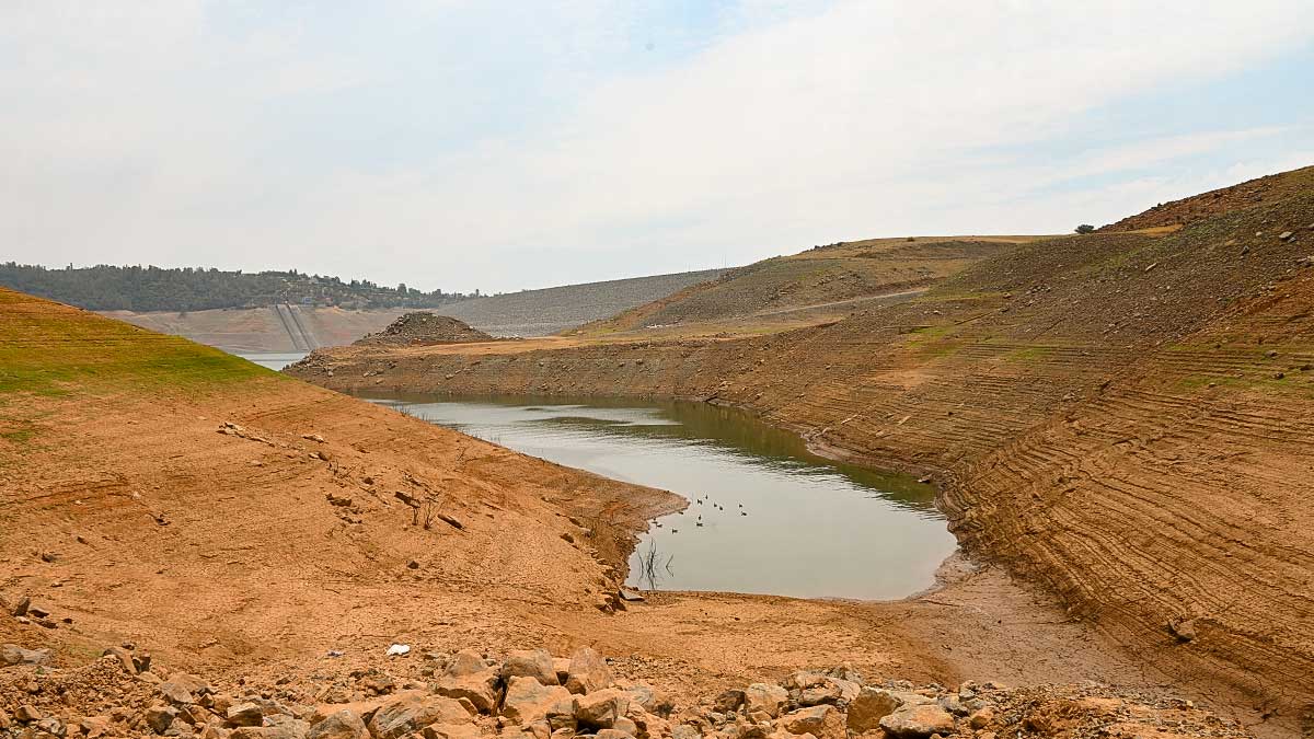
Siberia is once again covered in wildfires, and it is only June. Temperatures have soared to 118 degrees, and in Canada to 121 degrees little more than a week later. The United States is in the worst drought in 1,200 years. Cities and towns in Utah, Arizona, Nevada, Colorado, New Mexico, and California are staring a water crisis in the face. Hoover Dam, a symbol of American will, technology, and engineering prowess, is slowly becoming a monument to hubris. But the weather is not climate, and climate is not weather.

In Alaska, the debate on opening up drilling permits on the North Slope continues to rage, but the point is moot. Almost no oil companies are interested in drilling in Alaska. The melting permafrost has turned the ground into soup during the summer. The ice road season, critical to bringing in heavy materials and equipment, gets shorter every winter.

The weather data before us is undeniable. To call it fake news would require accepting that this is a conspiracy at a planetary level involving governments that actively work against each other such as Russia, China, and the United States. CO2 levels on the planet are at the highest level in 4.5 million years. Melting permafrost in the Arctic releases methane gas trapped in ice, a greenhouse gas ten times more potent than carbon dioxide.

In the Pacific Northwest and Canada, crops literally cooked in the fields. Entire berry harvests have been wiped out from Oregon to British Columbia. Roads buckled from the heat, and the light rail had to stop operating because the tracks were so overheated. Industrial coolers at grocery stores failed and caught fire from the heat, resulting in stores losing their perishable food products. This after 16 months of spot shortages within the supply chain due to COVID.

Young hawk chicks jumped out of nests due to the extreme heat, and rescues are overwhelmed with so many hawks they have to rescue. Lose your raptors, and you get an explosion of rodents. Rodents destroy desired grasses creating erosion, and wipe out crops, as we see in Australia.

On Mount Rainier, 35 inches of snowpack melted in four days. The initial pack was 53 inches, leaving just 18 inches behind. The water is rushing down creeks and rivers and washed away bridges in the park. That water, the Pacific Northwest’s drinking water, is rushing out to the Pacific Ocean. It isn’t supposed to melt that quickly.

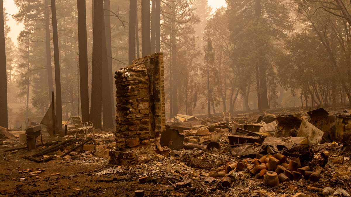
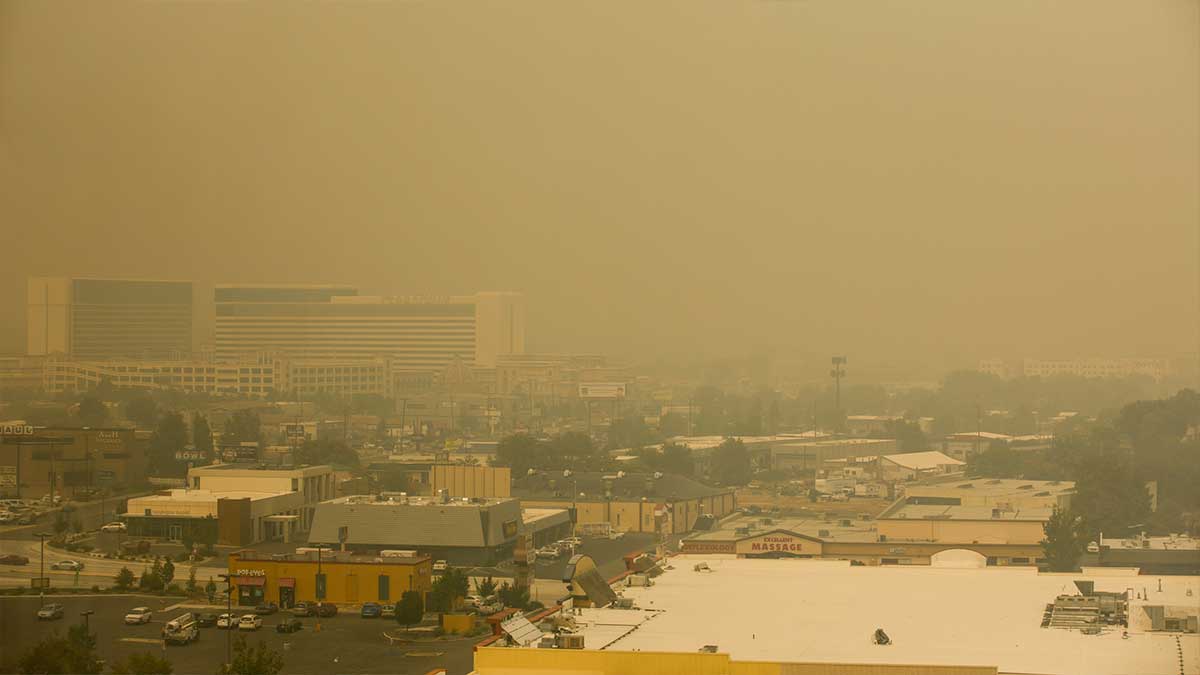
Last year in Oregon, Washington, and British Columbia, rain forests burned in defiance of the definition of a rain forest. This year Forks reached 109 degrees on June 28, and although another 100-degree heatwave is improbable for the region, the hottest part of our summer is about six weeks away. Cliff Mass wrote in 2016 that the wildfire smoke that blanketed our region was the product of poor forest management in the United States and unusual wind patterns. Wildfires have gotten worse each since except one, and 2020 was the worst year for smoke in Puget Sound. But the weather is not climate, and climate is not weather.

Greenland is losing 200 billion tons of ice a year, Antarctica, 100 billion. Arctic ice has declined steadily since 1979 in terms of area covered and has lost 66% of its thickness since the first nuclear power submarines sailed below the top of the planet. 85% of the glacier on Mount Kilimanjaro has melted since 1912 and is predicted to disappear in our lifetimes. Glacier National Park is well on its way to having no glaciers within its boundaries. Melting ice exposes darker surfaces, which absorbs more heat and causing higher temperatures.

Al Gore was mocked for an Inconvenient Truth and although there was creative liberty and some things were off the mark (Florida tidal flooding hasn’t reached the scale of the movie, flooding in some communities during normal tides has started), there is a lot he got right.

Communities in Maryland, Louisiana, South Carolina, and Virginia are slowly disappearing due to sea-level rise. The US Navy is working on addressing the sea-level rise in Norfolk. The melting polar ice caps are also considered a military strategic problem that the United States is ignoring. But the weather is not climate, and climate is not weather.

In Canada, it was so hot yesterday some aircraft could not engage in water drops to fight wildfires. For helicopters, the air-cooled engines were overheating even at altitude because the heat was so extreme. The thinner hot air impacts lift for fixed-winged aircraft, reducing the amount of water the aircraft could carry and possible water collection locations.

So what do we do? That’s the real challenge. In the United States, our government has reached a terrifying level of dysfunction with no political will to do anything. Russia is more than content to watch the United States tear itself apart. Indian and China, as rapidly developing nations with over a billion people, are moving to modernize through electrification and building middle-class societies. Both nations are walking away from coal power but are working toward long-term plans, not instant solutions.

China is facing its own energy crisis as 4-million Chinese enter the middle class every month. With a push to walk away from coal energy due to horrible pollution, the nation is pushing to project its power into the oil and natural gas-rich fields of the South China Sea. An effort by China that has been going on since the 1990s.

Here in the United States, there is a need for 7-million more homes because we’re deep in a housing crisis. That many homes require land and infrastructure. That requires cutting down trees, clearing grassland, or converting farmland into housing plots. All of this accelerates warming.

If the answers were simple and short term, we would do them. The human species is awful at setting long-term multigenerational goals. We know from our experiment of shutting down most of the global economy for a year that despite pollution free skies for cities around the world 12 months ago, the needle didn’t move on reducing the CO2 level. For some, that means, “well, what can we do?”

The late comedian George Carlin had this to say. “The planet isn’t going anywhere. We are! We’re going away! We’re going away, and we won’t leave much of a trace either. The planet will be here; we’ll be long gone; just another failed mutation; just another closed-end biological mistake; an evolutionary cul-de-sac. The planet will shake us off like a bad case of fleas, a surface nuisance.”

“The planet will be here for a long time after we’re gone, and it will heal itself, it will cleanse itself cause that’s what it does. It’s a self-correcting system. The air and the water will recover, the earth will be renewed, and if it’s true that plastic is not degradable, well, the planet will simply incorporate plastic into a new paradigm: The Earth plus Plastic.”

Humans cannot inhabit places that reach 122 degrees (50 degrees Centigrade) without massive infrastructure. Even then, being outside for more than a few hours can be fatal, even for the healthy. In the United States, the list of cities and towns creeping closer to those record highs, or exceeding them, are growing. Trained soldiers in the desert are in far better shape than the half of the United States that is obese and the one-third of the countries with diabetes or pre-diabetes.

The grim reality is this isn’t about saving the planet or the countless species that live with us who are dying off at the fastest rate in planetary history as I type this. Carlin is 100% correct, and the earth can shake us off like a bad case of fleas anytime it wants to, and nothing will care. The planet has shown that some other creature who found a way to survive, adapt, in this mess partially of our creation will live off of our wreckage, slowly evolve, and take over the surfaces or the seas, and everything we were will be forgotten forever. Even the satellites orbiting earth will eventually deorbit over time and disappear. The only traces left being microplastics, deeply buried ruins, and some strange pieces of equipment resting on planets in our solar system that must have been put there by some intelligent alien race.

Now that isn’t to say the end is near, and this great removal of the human flea on planet Earth is happening next year or the next decade. But if we don’t do something about it, we will soon live on a planet fighting increasing harsher wars over arable land, potable water, and places with temperatures below 122 degrees. We need to choose wisely in the few years we have left to respond.

If you’re looking to me to provide an answer on what to do, I don’t have one. I simply don’t know. If I use an analogy of a car, we have been driving a car, and now and then, the engine temperature gauge gets just below the red, and the check engine light is on. But instead of doing something about it, we keep driving. The car is still running today, but the engine temperature is now in the red, and steam is coming from the engine bay. The passenger in our backseat is screaming, “No! No! Don’t stop! Just keep driving because if you stop driving, everything will break.”

Save the planet? Who is going to save us, if not us.

Updated: Unprecedented heatwave obliterates weather records from Canada to California

[KIRKLAND] – (MTN) The heatwave that roasted the Pacific Northwest isn’t over, with eastern Washington, Oregon, and Idaho facing all-time record highs on Tuesday. For the western side of the Cascades and Siskiyous, things will be closer to normal except the central lowlands and southwestern Washington, where highs will be 15 to 20 degrees above normal.

Here is a list of new all-time records that were set during the heatwave, which continues in eastern Washington and Canada:

Washington All-Time Highs

  • Richland – 118 degrees June 29, which ties the all-time record high for the state of Washington with Dallesport Airport on June 28 and Ice Harbor Dam, the original record holder
  • Dallesport Airport reached 118 degrees which tied the all-time record high for the state of Washington
  • Bellingham – 99 degrees
  • Hanford – 115 degrees
  • Hoquiam – 103 degrees
  • Olympia – 110 degrees
  • Quillayute – 110 degrees
  • Seattle – 108 degrees
  • Spokane – 109 degrees June 29
  • Vancouver – 115 degrees

Oregon

  • Astoria – 101 degrees (tie)
  • Corvallis – 110 degrees
  • Eugene – 111 degrees
  • Hermiston – 117 degrees June 29
  • Hillsboro – 114 degrees
  • Hood River – 109 degrees
  • McMinnville – 114 degrees
  • Medford – 115 degrees
  • Pendleton – 113 degrees
  • Portland (Airport) – 116 degrees
  • Redmond – 110 degrees
  • Roseburg – 114 degrees
  • Salem, Oregon reached 117 degrees, which is the highest temperature ever recorded west of the Cascade Mountains in Oregon or Washington
  • Troutdale – 116 degrees

California All-Time Highs

  • Yreka – 109 degrees (tie)
  • Sandberg – 107 degrees

Canada All-Time Highs

  • Lytton, British Columbia set an all-time high of 121 degrees (49.6 C) which is also the highest temperature ever recorded in Canada on June 29, breaking the record set on June 28
  • Nahanni Bute, Northwest Territories – 101 degrees, which is an all-time record for the Northwest Territory
  • Banff, Alberta – 98 degrees
  • Calgary, Alberta – 94 degrees
  • Edmonton, Alberta – 94 degrees
  • Grand Prairie, Alberta – 101 degrees
  • Jasper, Alberta – 102 degrees
  • Abbotsford, British Columbia – 109 degrees
  • Kelowna, British Columbia – 109 degrees
  • Prince George, British Columbia – 101 degrees
  • Squamish, British Columbia – 109 degrees
  • Victoria, British Columbia – 103 degrees
  • Whistler, British Columbia – 106 degrees
  • Williams Lake, British Columbia – 101 degrees