Category Archives: Weather

Tornado outbreak expected today

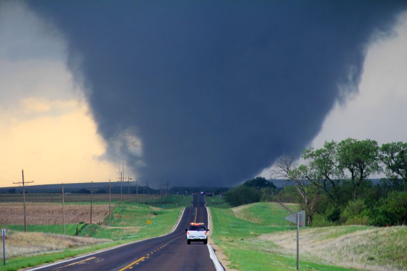
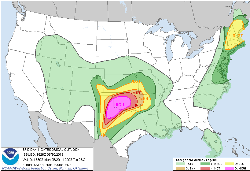
It is going to be a rough day in northern Texas and central Oklahoma. Conditions have lined up to create the first High Risk warning from the Storm Prediction Center in two years. As I often write, the weather is not climate; the climate is not the weather. The geography and intensity of this forecast are not out of the “norm,” despite High Risk warnings being rare. For the heart of Oklahoma and part of the Texas panhandle, there is a 45% chance of a tornado forming today, and a better than 10% chance that any given tornado will be EF-2 or stronger. In plain English, that means if you live in Oklahoma City, there is a 45% chance today that a tornado will touch the ground within 25 miles of where you are sitting. There is a 10% chance that tornado will be EF-2 or stronger. That kind of odds schools close and businesses send people home.

Tornado-producing supercells need several things to form. They need energy, and that comes in the form of high humidity. Dew points in the area are in the 70s, which is ridiculously high humidity. That is the kind of humidity where you walk out of the house, and your clothes stick to your body two minutes later. You need convection, you need high temperatures, and you can’t have a “cap,” that is a temperature inversion that traps warm air close to the surface. Finally, you need wind shear, that is the wind at different altitudes traveling in different directions, and you need a lot of wind shear. High dew points and unstable air can create amazing thunderstorms, but it is the wind shear that turns them into rotating supercells. There is one other element that enhances the development of tornadic producing storms, individual cell development. Thunderstorms that form in a line along a front can produce tornadoes, but the mechanics (which I’ll spare here) of the storms combine and act to moderate supercell and tornadic development within the cells. It is the stand-alone cells with a forecast model like today, that can form and produce the largest tornadoes.

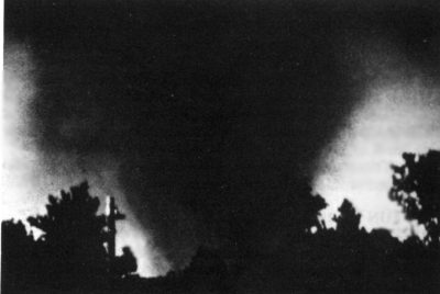
Tornado damage is measured using the Enhanced Fujita scale. Tetsuya Fujita and Allen Pearson developed the Fujita scale to measure the strength of tornadoes consistently and started using the scale in 1971. It was updated in 1973 and 2007 when it became the Enhanced Fujita Scale.  The scale goes from EF-0 to EF-5. An EF-0 can raise your blood pressure, break large branches off a tree, take some shingles off the roof, crack some windows, and send the trash cans into the neighbor’s yard. An EF-5 can suck the pavement off of the ground, toss loaded rail cars like children’s toys, and leave nothing but a concrete slab behind when it passes over a house. The 1996 movie Twister may be loaded with pseudoscience and hyperbole, but the description of an EF-5 tornado as, “the finger of God,” is correct. As a civilian, there are only three ways to escape an EF-5, get out of its a path (never attempt to outrun a tornado), go underground, be in a specialized tornado shelter built to survive an EF-5 — the end.  

Storm Prediction Center Convective Outlook for May 20, 2019

In addition to the extreme danger in the central Midwest, there is a more than a small chance for tornadoes in most of Connecticut, western and central Massachusetts, almost all of New Hampshire and the western part of Maine. This too isn’t an “unusual,” forecast for this time of the year. You might be surprised to learn that Massachusetts suffered one of the most destructive tornadoes in United States history in 1953. There remains debate among scientists if the Great Worcester Tornado was an EF-4 or EF-5 storm, and the damage has gone through an unprecedented review twice. For today the storm stands as a very strong EF-4.

The Great Worcester Tornado in 1953, taken as it reached EF-3 strength in Holden, Massachusetts

Although watches, warnings, and forecast models have gotten much better, and research has gotten more extreme, the average warning times for tornadoes remains excruciatingly short. Yesterday, in a real-life Twister not based on Hollywood fantasy (I’m harsh, it is easy to call out everything the movie Twister got wrong, but it did get a lot right) Reed Timmer was able to drive his Dominator 3 vehicle into a tornado and get 3 drones deployed. As much as we may understand our world, we still don’t fully understand the mechanics of why some supercells produce tornadoes and others don’t. The more we can learn, the better we can understand what a tornadic supercell looks like in early development, and the earlier we can issue warnings. For that part, the movie Twister got 100% right. Stay safe out there, and if you live in one of these areas under an Enhanced, Moderate, or High Risk categorical forecast, keep your eye to the sky and have your survival plan in place.

Uncertainty and the weekend forecast

Weekend weather for the 17th to the 19th of May. Friday and Saturday are clear, Sunday is very tough to call. On to the forecast!

Friday will start wet, and for Kirkland specifically, things could be very wet with a Puget Sound Convergence Zone forming overnight. The question with the CZ is always where exactly. The further north you are of the King-Snohomish line, the more likely you’re in the wet, but it is possible for the zone to form a little further south. If you’re south of downtown Bellevue and Seattle, the rain will be lighter and turn to showers earlier in the day. Friday afternoon looks, “OK,” and Friday night dries out further.

Saturday we get an onshore flow, the same wind direction that gave us our mini-heatwaves in March and last week. We won’t see temperatures soaring into the 80s, and it will be mostly cloudy, but it will get into the 70s with an increasing chance of rain on Saturday.

Sunday – this is the tough forecast. Models are all over the place on how much rain but it will rain. Most of it will be during the overnight hours and should be lighter than the rain we’ll see tonight and Friday morning. We then have a general chance of rain and “normal” May weather out until Tuesday of next week. Given how wide apart the models are, I’ll make another call on Sunday tomorrow and update.

For weekend outdoor plans Saturday is your day – won’t be bright blue skies but it will be dry.

Another record high likely to be set for May 10

The official high-temperature yesterday at KSEA (Seattle-Tacoma International Airport) was 83, which bested the old record of 81. We started at a low of 57 (like yesterday) this morning, but there are some key differences. We have a very light wind coming from the southeast today and almost no chance for cloud cover unlike yesterday, which dropped midday temperatures at Seatac 3 degrees.

The official forecast high is 84, but as I’ve written in the past regional weather models don’t seem to capture the onshore flow forecasts that well, so my prediction is Seatac will get to 86 today. That easily bests the May 10 record of 83 degrees.

Kirkland will see a range of 81 to 88 depending on your microclimate. Down by the water, and the high points on Finn Hill and Kenmore will see lower temperatures. Our area hot spot of Totem Lake will likely get into the high 80s today.

Tomorrow is going to be even hotter. Stay cool Malcontents!

A new record high for May 9th

It won’t be officially in the record books until tomorrow morning, but unofficially KSEA (Seattle-Tacoma International Airport) reached 83 degrees today, beating the old record of 81.

Tomorrow will be hotter, with the record of 83 almost certain to be broken. Saturday appears to be even hotter, with the old record high of 87 at risk.

Stay cool out there!

Record high temperatures coming May 9 – 11

The record high for Thursday is 81 degrees, that one is “at risk.” Record high for Friday is 83 degrees, that one will likely get shattered. Record high for Saturday is 87, that is going to be tough to beat.

Back into the 70s for Mother’s Day. 

There have already been 219 lowland wildfires in Western Washington since March, which is a record. The coming record warmth, coupled with reduced rain and dry air will be raising fire risk.

Welcome to the new normal.

Area lakes and rivers are still dangerously cold

This happens every year in Puget Sound and it is unnecessary. We get a warm spell in May or June and people head to the lakes and rivers to cool off. What better way than a swim, a float trip, a canoe, or a kayak?

Don’t be fooled, our area lakes and rivers can kill you this time of year.
Lakes are still cold, hypothermia can set in quickly leading to a loss of coordination and drowning. Unless you’ve ever experienced a kayak/canoe overturning suddenly, you have no idea how disorienting the experience really is. 

For our rivers, flow and levels are high with continued snow melt and there are a lot of limbs and branches over the waterways after our February snows (called strainers). High flow plus branches in the water are certified drowning machines. If you get up against a strainer, the water pressure keeps you there. The end. Rivers are even colder than lakes also.

If you’re going to head to the water to enjoy the warm please:

1) Don’t swim alone or at night
2) Don’t drink and swim
3) Don’t go over your head, you can cramp up suddenly
4) Canoe, kayak, etc. wear a life jacket
5) Don’t venture out on the rivers unless you have reviewed official reports and/or scouted the runs yourself – wear a lifejacket, don’t go alone, have a recovery plan
6) Smaller children are more susceptible to hypothermia, keep an eye on them and watch for shivering, blue lips, and chattering teeth

Please be safe.

Get prepared for summer smoke now

TL;DR

  1. Growing evidence that our climate is changing
  2. Puget Sound now has some of the worst air in the country
  3. Summer is coming and with it likely more wildfires
  4. You should prepare now
  5. Particulate matter is horrible for your lungs, and you don’t realize you damaged your lungs until it is too late
  6. N-95 masks help and don’t make you look like a dork, but don’t help everyone
  7. Consider creating a clean air space in your home
  8. This sucks

Climate is not the weather.

The weather is not climate.

Weather patterns are changing globally. When looked at as a whole, there is a growing body of evidence that these changes, which started hand-in-hand with the Industrial Revolution, are resulting in climate change.

The Arctic regions have seen one of the biggest shifts with extreme warm spells, shrinking glaciers, ice sheets, and seaside communities washing into the ocean. Permafrost frozen for more than 40,000 years is become less – permanent. In other regions, like the lower 48 of the United States, the changes are more subtle. Earlier springs, longer falls, increased rainfall when it rains, longer dry spells when there is drought. Here in Puget Sound, a growing addition to this change is smoke.

It is with a hardy and sarcastic, “congratulations,” Puget Sound now has some of the worst air in the United States. Those bluest skies I’ve ever seen as in the song have turned increasingly hazy, and over the past two summers, toxic. Most of this change is due to wildfires that have surrounded our region. Prevailing winds blow the smoke into the Puget Sound region where it gets trapped. The only thing that pushes it out is marine air off the coast, which then turns our skies gray with clouds and drops the temperature into the 60s and low 70s. Our spectacular Augusts replaced by days of 90 plus degrees with orange skies and the smell of burning forests or 65 degree days with drizzle and low gray clouds – but on those days we can breathe.

The reasons for the fires are more complex than weather events or a shift in climate. Poor forest management, increased human activity in forested areas, communities expanding into forests and grasslands, and an increase in “dry thunderstorms,” has conspired to generate more fires. The longer growing seasons, which are weather related, generate more fuel, while hotter summers dry out that fuel faster.

The ironic part is the smoke moves more people to motorized transit, which increases traffic, which creates more pollution, which makes it worse – but the pollution created by vehicles is not the particulate matter created by wildfires. The engineered congestion in Puget Sound creates lung congestion on our worst days.

Our declining air quality due to climate change and forest management isn’t just a Terra Firma Thursday issue; this is also a Weighty Matters issue. In other parts of the world, it isn’t just common, but it is socially acceptable to wear masks when sick or when pollution is severe. In the United States, this is met mostly with snickers.

The fine particulates that turn our skies orange in the summer are terrible for your lungs. The particulates accumulate, that is get trapped inside your lungs, and over time permanently damage your lung capacity. This decrease in capacity is insidious as it happens gradually and over the years. Of all the functions in our bodies, lungs go the longest before revealing to us there is a real issue – and then it is too late to reverse the damage.

As we start to approach summer, with another long-range forecast model of, “hotter and dryer than the norm,” now is the time to get prepared.

  • Get some N-95 masks. When the smoke starts, they’ll become more difficult to find. You can buy them online from many websites including Amazon, Home Depot, and Lowes. Remember, N-95 masks only work when tightly fitted to the face. Small children and those with facial hair can’t use them. Additionally, N-95 masks are not designed to be worn for days on end. Which means you need to limit your overall exposure when the smoke is bad.
  • Surgical masks don’t block fine particulates, they don’t work.
  • Our smoky days typically go hand-in-hand with our hottest days. In 2018 we had several days that would have been record-shattering, 100 degrees plus, but the smoke kept our temperatures down 3 to 6 degrees in the high 90s. Ideally, on the worst days, you should keep your windows closed. Now is the time to consider a portable air conditioner for at least one room, to create a clean air space in your home.
  • Along with a room with AC, having a box fan with a furnace filter taped to the “intake” side (the side that pulls the air) has been shown to dramatically reduce particulate matter in the air. If you can’t afford an AC, a $20 box fan and a $10 filter can significantly improve air quality in a single room. Ideally, if possible, you should do both.
A furnace filter duct taped to a box fan is a low cost way to clean the air in a single room.

  • When you drive your car run your AC and run it in the “max” or “recirculation” mode. This recycles the air within your cabin. If your car doesn’t have working AC, you’ll need to wear an N-95 mask when driving.
  • On the worst smoky days don’t do outdoor activity if you can. If you work outdoors, your employer should provide N-95 masks. This is vital on days where there is ash fall.
  • Exercise should be done indoors in a climate controlled setting. If you have medical issues, to begin with, avoid exercise or better yet, talk to your doctor.
  • Contact wearers should make sure now that their glasses prescription is up to snuff. On the worst days, you’ll want to rip your eyeballs out when you’re wearing contacts.
  • Ash is very alkaline and damaging to car paint. Additionally, ash can create spiderweb scratches in auto finishes. On days with bad ashfall consider rinsing your car off with a hose. Smoke is generally not as bad during the morning hours as we get some marine air trying to push in. If it is down to your lungs or your car paint, you should choose the lungs.
  • Welcome to the new normal.