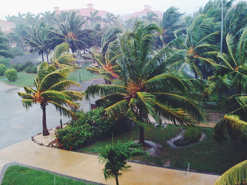
Zeta strengthened to a Category I hurricane with 80 MPH as it continues its northwestward march toward the Yucatan Peninsula of Mexico. Officials in Cuba discontinued the Tropical Storm Warnings for the western part of the island nation as Zeta moved away. US officials issued a Hurricane Watch from Morgan City, Louisiana, to the Mississippi-Alabama border. The Hurricane Watch includes Lake Ponchitrain and New Orleans.
In Mexico, Hurricane Warnings include the island of Cozumel, battered three weeks ago by Hurricane Delta. Zeta is expected to pass over the Yucatan Peninsula Monday night, then emerge back into the Gulf of Mexico, where it will gather strength. Forecast models indicate that heavy rain from the system could be lashing the Gulf Coast of the United States by Tuesday night.
WDSU of New Orleans reports voluntary evacuation orders in Orleans Parish for those who live outside of the levees and in Jefferson Parish for all residents. Additionally, mandatory evacuation orders for all campers, RVs, and boat residents on Grand Isle. Zeta will be the 11th named system to make landfall on the United States in 2020, a record, and the fourth system to strike the Yucatan Peninsula.
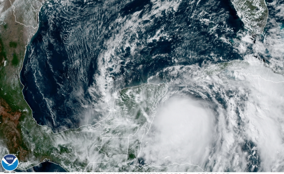
Tropical Storm Zeta, the 27th named storm in the 2020 hurricane season, is churning in the Caribbean on a collision course with the Yucatan Peninsula.
The earliest 27th named storm in history, Zeta is expected to strengthen into a hurricane before making landfall Monday night or early Tuesday morning, local time. Zeta has sustained winds of 70 MPH, just under hurricane strength and moving northwest at 7 MPH. Hurricane warnings are posted along the northern tip of the Yucatan Peninsula, and Tropical Storm Warnings are posted in western Cuba.
Hurricane battered east Texas, Louisana, and Alabama are once again in the bullseye. With confidence growing, Zeta would be the 11th named storm to make landfall in the United States, with projections indicating the storm will arrive Wednesday evening. If Zeta makes landfall in the United States, it would be a record-setting eleventh tropical system to strike the United States in a single hurricane season.
Officials advise Louisiana residents to prepare for yet another tropical system, with storm surge, wind, and flooding rains.
The holiday weekend is almost here. I’ve written in the past
how meteorological summer is June 1 to August 31, so the first day of
meteorological fall is upon us! Seasonal fall for the non-science community is
from the Summer Solstice to the Autumnal Equinox, which is very late this year
at 12:50 PM on September 23rd! (that isn’t a typo). What I would call spiritual
summer in Puget Sound goes from July 5 to sometime in October when the machine that
runs fall gets turned on. If you’re confused, don’t worry. You can be
pessimistic and look at summer being over this weekend, or see the glass
half-full and see a few weeks of summer left, or be optimistic and revel in at
least six more weeks of decent weather to come.
What about the long weekend?
If you aren’t a native or a long-term resident, you have probably
concluded this summer has sucked. You would be wrong; this summer has been utterly
average for Puget Sound. This coming Labor Day weekend is more of the same. If
you don’t like the heat, you’ll be happy to know that for Kirkland, we’ll see
temperatures through the weekend from 77 to 81, depending on where you are. The
highest hills and right by the water will be the upper 70s; our Totem Lake hot
spot will eek into the 80s.
What about the sun? Well it won’t be very plentiful, but it
won’t be shrouded in low clouds either. We’re looking at mostly cloudy days,
that will improve in the afternoon. Saturday will be the most overcast day. It
will still be warm, but we aren’t going to see much sun.
Rain, that’s the important one, will it rain? Well, maybe.
Looking at the weather models individually and the ensemble, there is a 20% to
40% chance of rain hour by hour from Thursday to Monday (Monday is more than 72
hours out so a bit of a dart throw today). Nothing looks like soaking rain, and
we’ll likely get a few stray showers tonight (Thursday). If I were to place a
bet on the best chance for some morning drizzle or some rain, Saturday
afternoon to Sunday morning looks like the best chance (or worse if you do want
to view it that way).
As for looking into the crystal ball a bit further, next
week when all the kids will be back in school is looking like more of the same.
Some AM gloom that burns off and temperature in the 70s. You know, normal.
So you want to know about the weather forecast for the
Fourth of July? Errr mer Gerd, it’s cool and cloudy! It’s June Gloom in July;
the fourth is ruined! Relax.
Today we are going to be well below normal with high
temperatures topping out from 60 to 65 depending on your location in Kirkland.
Basically, the needle isn’t going to move much through the day. We’ll have a
thick blanket of clouds but can’t rule out the sun peeking through from time to
time. We’ll get another round of scattered light showers this afternoon and
evening – stress scattered and light.
Wednesday will be more cloudy then sunny, and there is a
chance in the morning for some drizzle or a stray shower. Temperatures will be
70 to 75, and the afternoon will clear up. In other words, Wednesday is going
to be a textbook June Gloom day.
The Fourth, the big day, the event, it will have Air Force
planes, tanks, VIP seats for Republican donors, screaming eagles, and an orange
leader. Oh, that’s Washington D.C., I digress. For us, we’ll start cloudy, but
no chance of rain or drizzle. The clouds will burn off to a spectacular day
with high temperatures of 71 to 76. It is going to be a beautiful day and clear
for fireworks.
Looking forward past the fourth of July, our unofficial start of summer (July 5) is also textbook for Seattle. Partly cloudy to sunny through the period, almost no chance of rain, with temperatures warming up to the mid-80s by the middle of the month.
Lowest tides of the year
There is also a special bonus for this Fourth of July. Puget
Sound will be having the lowest tides of the year this week, and they are timed
ideally. For the Duwamish Head:
Tuesday: -3.0 feet @ 11:14 AM
Wednesday: -3.4 feet @ 11:58 AM
Thursday: -3.0 feet @ 12:43 PM
Friday: -3.0 feet @ 1:31 PM
This is our annual chance to tide pool and it is happening when a lot of people have the day off. Remember to know the tides, don’t get stranded, wear the right footwear, and be safe. It will be very slippery out there. Also, remember not to harass the sealife and use leave no trace ethics.
Jetty Island Ferry starts daily service
Also! The Jetty Island Ferry in Everett starts its annual daily runs on Friday, July 5, 2019. The first ferry of the year will launch at 10:00 AM. From Friday to Sunday the ferry runs from 10:00 AM to 9:00 PM, you can see the schedule here. Please note that ferry runs can be canceled due to extremely low tides, so it is likely ferry service will be disrupted this upcoming weekend. If you plan to visit Jetty Island, especially midday to the afternoon on Friday, Saturday, or Sunday, call ahead for schedule information.
Some people call it Juneuary; others call it June Gloom. If
you live on the Pacific Coast, from San Diego to Neah Bay, we all get sucked
in. April rain gives way to sunny days in May and just as the temperatures get
into the 70s, surprise! The fog rolls in, low clouds, morning drizzle, and
temperatures that struggle to get to 60. A long-standing Puget Sound joke is
summer begins on July 5th, as the lingering gloom hangs on into early July.
We already had record heat earlier this month, including a
blistering 95-degree day. Our warm sunny streak sputtered over the previous
weekend, and June Gloom hung over the region with low clouds and drizzle. Get
ready; more is coming.
Today (Tuesday) is going to be the nicest day of the work
week. We’ll have more sun than clouds and our high 40s and low 50s of this
morning will give way to mid-70s later in the day. Tomorrow will start similar
but will go downhill.
Wednesday afternoon the clouds will thicken, the air will
get unstable, and rain showers will start up. It wouldn’t be out of the question
to get some rumbles of thunder.
Wednesday night, Thursday, Thursday night, Friday, and
Friday night? June Gloom in full force. Cloudy with some sun breaks, rain
showers, drizzle, low clouds, and temperatures slightly below average.
This upcoming weekend, which will be the start of a vacation
week for many, looks nice. Morning clouds on Saturday (and I’m guessing drizzle
only because it wouldn’t be the Greenwood Car Show without rain for at least
part of the day – ARGH) will give way to a day similar to our Monday, complete
with highs in the 70s.
So why June Gloom? Well, you can blame it on the Pacific
Ocean. As we get into late meteorological spring, soil temperatures and inland
waterway temperatures increase, while the vast waters of the Pacific Ocean need
more time to catch up. Warm ground + cool marine air flowing inland =
condensation. Cold air sinks and that creates low clouds and fog. The moisture is
squeezed out of the atmosphere, low clouds become saturated, the air can’t hold
the water anymore, and we get drizzle and light rain. As our days get longer
and the sun sits higher in the sky, the marine air dries out, and we get sun breaks
that turn into blue sky late afternoons. The sun goes down; the air cools, the
marine air rushes back in, repeat.
What about the Fourth of July? Well, that’s throwing darts
at this point, but long-range models appear to indicate it will be pleasant.
Stay tuned for more.
We sure have been using a lot of Wite-out and erasers in the record books this year, and after the record high of yesterday, new records were set just as the sun was rising on the 12th of June.
Seattle-Tacoma International Airport set a record for the warmest low temperature for June 12, where the mercury dropped only to 65 degrees for a few minutes. That beat the old record of 56 degrees and was the fourth warmest June low temperature since weather records have been kept in Seattle.
The official forecast is for 89 degrees, but as I’ve written previously the computer models don’t do a good job of capturing the impact of thermal troughs on our high temperatures, and forecast low. We saw that yesterday with an official forecast high of 83, and an actual high of 87.
We have more cloud cover today that helped hold the heat in overnight, and will moderate our temperatures, slightly. That’s the wild card, how much cloud cover, for how long, and does it thicken up during the heat of the day. There is the slimmest chance of some showers drifting off of the Cascades this afternoon, but the humidity is very low so they’ll have a hard time not falling apart as they drift west.
If we don’t get thickening clouds between noon and 6 PM, expect the official high to land between 92 and 93 degrees, the forecast is 89. This will break the KSEA record of 85, and the Federal Building record of 88. As for Kirkland you can expect the entire community to hit 90 day, unless we get some stray drops. Wouldn’t surprise me to see Totem Lake around 93 or 94 -our area hot spot.
Stay cool and remember:
Juanita Beach is still closed due to e-coli contamination
Area lakes and rivers are still cold, be careful when swimming
Don’t leave your pets in your car – not even for a few minutes
Don’t leave your kids in your car – not even for a few minutes
Haggard? Tired? Stressed? Double check that backseat before leaving home, especially if you have kids or pets – shit happens
Bring patience to your commute, this kind of heat will test the mechanical condition of vehicles and expect stalls and breakdown to fuck up our area traffic
The headline says it all. We have a classic thermal trough setting up on Tuesday, we cook on Wednesday, and the heat falls apart on Thursday. We started June slightly warmer than normal (two outlier days that were very below normal) and with a typical, June Gloom, pattern. There is almost no chance for rain in the next 10 days (anything past 5 days is throwing darts). There is a tiny chance of some drizzle on Friday right now, but even that is too far off to predict with confidence.
Let’s start with Tuesday. Winds will pick up and be out of the north but then die out around midday. Kirkland is looking at a high of 80 to 83, depending on your location. High hills and right along the water, think 80 degrees, Totem Lake, our hot spot, 83. Tuesday night we will only get down to 60 degrees with a blanket of clouds moving in.
Wednesday is a little complicated. The models are calling for clouds to hold for most of the day and little wind, so this is a weak thermal trough. We’re looking at record-setting temperatures of 86 to 90 degrees in Kirkland. At Seattle-Tacoma International Airport (KSEA) the official weather forecast is a high of 89 degrees. This would break the previous record of 85. As I’ve written in the past, the computer models don’t do a good job of capturing the impact of thermal troughs in the forecast and usually predict 2 degrees lower than actual, so right now, I’m pretty confident we will see our first “official” 90-degree day on Wednesday. If we get a little more east wind, or the clouds break up sooner, we’ll be hotter. If the cloud blanket is thicker than the models indicate, we’ll be cooler. Stay tuned.
Thursday the thermal trough moves east, but Kirkland will still hit 80 to 83 degrees with a near copy of Tuesday. Friday the winds shift to the west, northwest again and the marine air pushes back in. That gives us our very slight chance for some morning drizzle on Friday, but nothing that will move the needle on our growing rainfall deficit.
Don’t leave your pets in your car. No having the window open isn’t enough. No, I just went in for five minutes doesn’t cut it. On a 90 degree day, the inside of your car can soar to 130 or 140 degrees in minutes. That is death, a horrible, awful death.
I shouldn’t have to say don’t leave your kids in the car — I really shouldn’t have to.
I shouldn’t have to say don’t throw your cigarette butts out the window when you drive because they can start a fire when the air is dry and warm, but it needs repeating.
Area lakes and rivers are still dangerously cold. Please have a talk with your teens if they have swimming, river floats, or boating plans. Jumping into water under 50 degrees can cause a gasp reflex you can’t control, inhale a big mouthful of water, and that’s it. It happens every year, and it has already happened in 2019. These are senseless, preventable deaths.
Ahhh, the weekend, a time of relaxation and for Puget Sound residents, of supreme importance during the summer months. This weekend forecast is a combination of bad news/good news.
First, the bad news, Friday is going to be a total washout
and it is going to be, dare I say it, cold for June. We won’t see 60 degrees on
Friday, heck the highest, coldest spots in Kirkland may struggle to get to 55
tomorrow. We’ll see rain showers that will be heavy at times, and it isn’t too
far out of the realm of possibilities for Kirkland to hear thunder and see some
hail. To add to the fun, we’ll likely see the heaviest precipitation in the
hours leading up to the evening commute, so pack your patience in the morning
for your drive home.
Now, the good news, after a washout on Friday the rest of
the weekend is looking very nice. Saturday and Sunday will both be completely
average early June days. Saturday will be the cooler, but temperatures will be
near normal in the high 60s. The day will likely start cloudy but get better
toward the afternoon.
Sunday will be a few degrees warmer, getting into the low 70s.
The day will be mostly cloudy, but it will be a marine layer in the morning
that slowly dries out, and the clouds will rise through the day.
For outdoor activity, either Saturday or Sunday is the best
bet, but forget Friday – that is going to be a total loss. Me personally, I’m hoping
for some booms and flashes tomorrow!
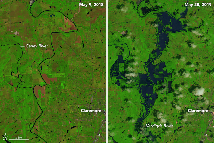
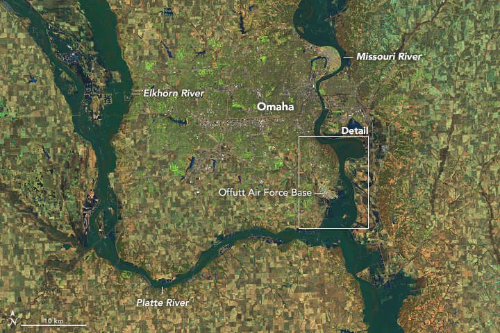
United States farmers are facing the worst crisis since the 1980s Soviet grain embargo. Although weather played a factor in the 1980s, the weather is a leading role in 2019. After years of drought impacting much of the country, the nation is now awash in water. Historical amounts of rain have created historic flooding, both in duration and ferocity, devastating farm operations across the United States.
In the first quarter of 2019, 160 farms filed for Chapter 12
bankruptcy, which would put 2019 for 600 plus filings, a 29% increase from last
year. The total number of farms in the United States has been
in steady decline since 2007, dropping about 10% in 11 years (statistics go
to 2018). Total land use for farming in the United States has
also declined during the same period, dropping about 5%.
Crop failures in the United States are at the worst levels
in 30 years, and in many cases, it is because arable land is underwater, or too
soaked to plant. Generally, at this time of the year, 79% of the cropland
dedicated to soybean production would be planted – today it stands at 39%. For
corn, the average would be 96% – today it is less than 65%. Farmers are facing
a now or never choice this week across the nation. File crop insurance claims
for, “prevented to plant,” and accept about 50 cents on the dollar on what
would already be meager profits for doing nothing, or roll the dice and plant
anyway. If they plant and the crops don’t provide a yield, they could file for
federal aid or insurance. That assumes that the farmer has coverage in the
first place.
Soil moisture levels were already at saturation for much of the eastern US by February, 2019
This crisis has been years in the making through a
combination of climate change, market conditions, and the political landscape.
In the 2000s, ethanol became mandated in US gasoline. Small ethanol producers
were bought up by large corporations, and farmers shifted to corn to sell to
the ethanol industry. The shifting of corn to ethanol production reduced the overall
supply of other grains and raised the cost of feedstock for farm animals. The demand
for beef and pork dropped due to rising prices. At the same time, rBST was
sending milk production through the roof, creating an oversupply. Dairy farmers
sent their herds to slaughter and gave up, while pork and beef producers sent
their animals to market at a younger age.
Flooding in Nebraska impacted military operations at Offutt AFB in March, 2019
Fast forward a few years later, and with smaller dairy and
livestock herds, demand for grains for feedstock plummeted creating a vast oversupply.
The price of corn, soy, and wheat collapsed, gutting the profits reaped earlier
this decade. The Obama Administration block the planned E15 ethanol mandate for
all US gasoline, and the Trump Administration continues to block the rule. The expected
increase in ethanol production never happened, adding to more oversupply and
further depressing prices.
Add in a buying embargo by China for US soybeans, tariffs, a
global oversupply of milk and milk products, US farmers were already reeling.
Congress playing a game of chicken for disaster aid didn’t help matters, and
the heartland of the United States will inevitably need more support going
forward.
The weather patterns producing this historical rain event
have eased, but there is still a tremendous amount of water that needs to flow
through these river basins for weeks to come. All of this spells bad news for
Louisiana, where the increased freshwater flow will accelerate land loss in the
Mississippi Delta, and hurt oyster farms and harvesters. The decrease in
salinity in the gulf lowers oyster yields.
Coming up next on the list of impacted agriculture from 2019 flooding, Gulf of Mexico oyster producers and harvesters
As for the ongoing flooding, in some cases, entire farms and
communities have likely been lost forever. The tangle of levees in many of
these regions is managed by independent cooperatives and local governments,
which don’t have the money or resources to update or maintain them. The Army Corps
of Engineers has already channeled and tamed the Arkansas, Missouri, and
Mississippi Rivers, so there is little left they can do beyond build dams and
levees they manage higher. Once a levee is overtopped, the flow of the water
eats away it, requiring major repair, if not a full replacement. If a levee blows
out at a middle point, the rushing water chews away at both sides. In many
cases, the strategy is to wait for the rain to stop and wait for the water to recede
– that could still be months away in some places.
As for the average American, in the short term, you can
expect lower prices at your grocery store for some commodities that aren’t Heche
en Mexico. Later this year as the full impact of the crop failures are felt,
prices will likely go up. Corn plays a huge role in the American food chain, as
a feedstock for farm animals that impacts meat, egg and dairy prices, as a grain
for cereals, and for corn syrup production as a sweetener. It also will likely
increase costs at the pump (more likely it will blunt the slow decline we start
to see after the Fourth of July holiday weekend), with the gasoline you put in
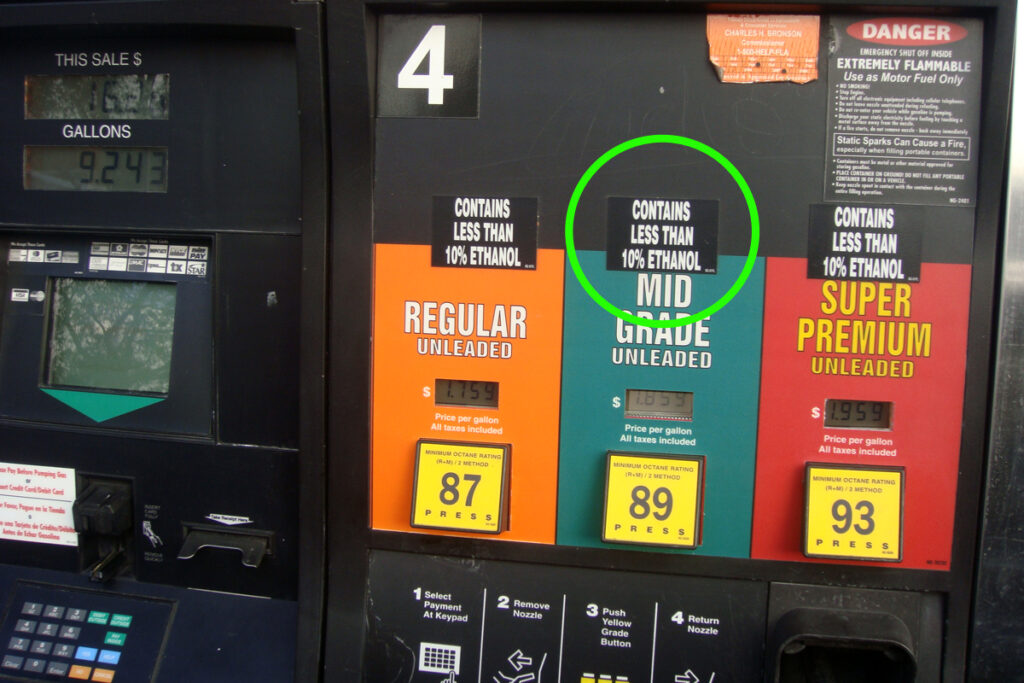
your car requiring 10% Ethanol content per federal law.
Copyrights 2008 Mario R. Duran (mariordo@aol.com).Release under Creative Commons Attribution – Wikipedia Creative Commons
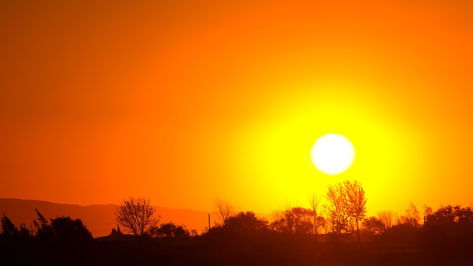
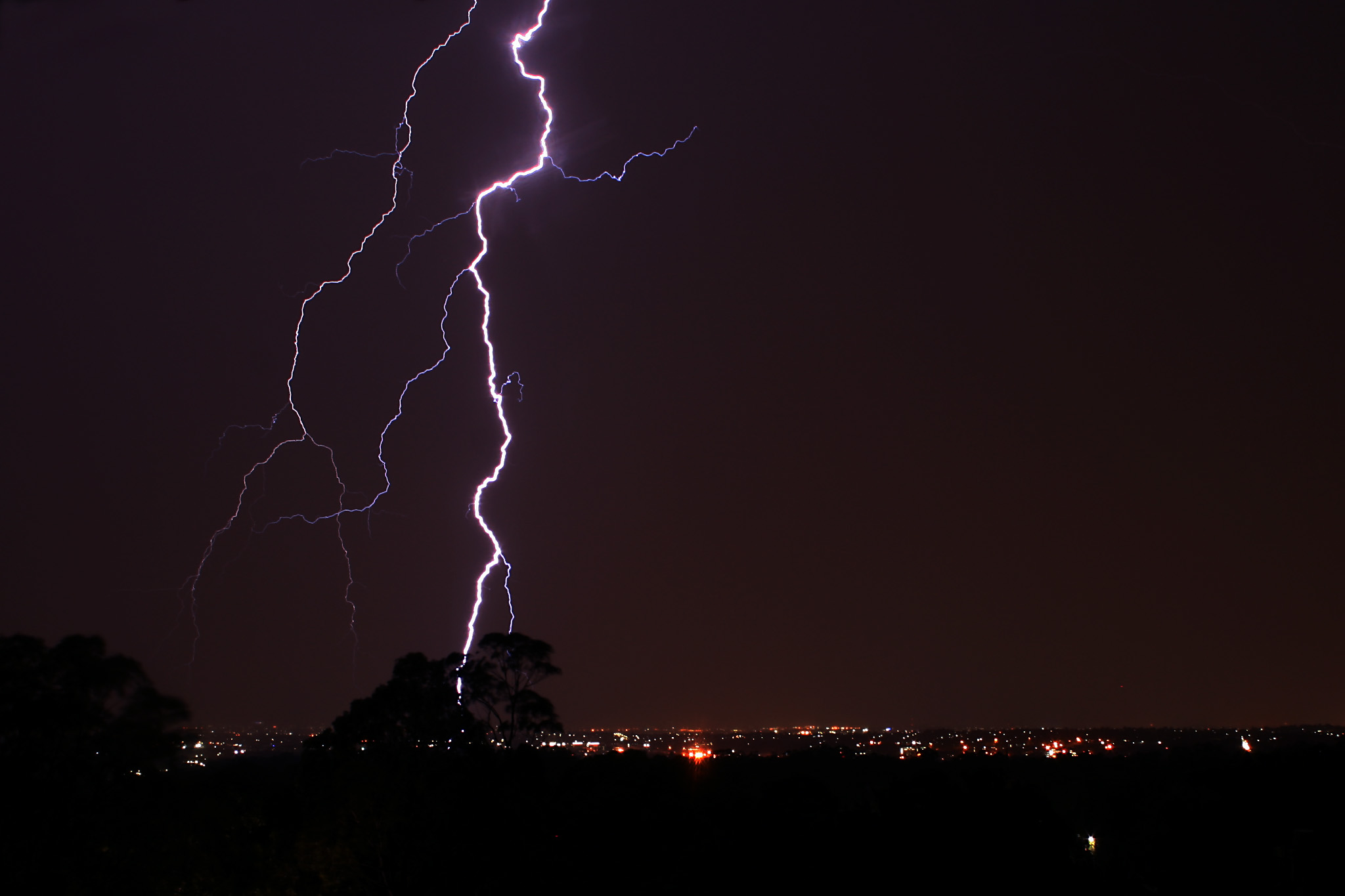
The impact of climate change continues to play out as
predicted in models that go back to the 1980s. The weather is not climate, and
the climate is not the weather. Single weather events don’t serve as proof a
change to this planet, but when taken together in aggregate, it is evident something
is wrong.
Think about it.
Malcontent, out.
Journalists, activists, and researchers defending the First Amendment
Subscribe to Malcontent News
Register to feed your head holes with the Malcontent News newsletter.
Submitting your e-mail address gives us permission to send you e-mails. We do not sell or distribute our e-mail lists or share them with third parties.