UPDATE 4:00 PM PST: The National Weather Service has extended the Winter Storm Warning until 9:00 PM PST due to continued moderate to heavy snow falling in some areas within the region. Moderate to heavy bands of snow will continue to develop into the evening hours. Some of these bands can quickly drop one to two more inches of snow. People are advised to continue to avoid travel if possible.
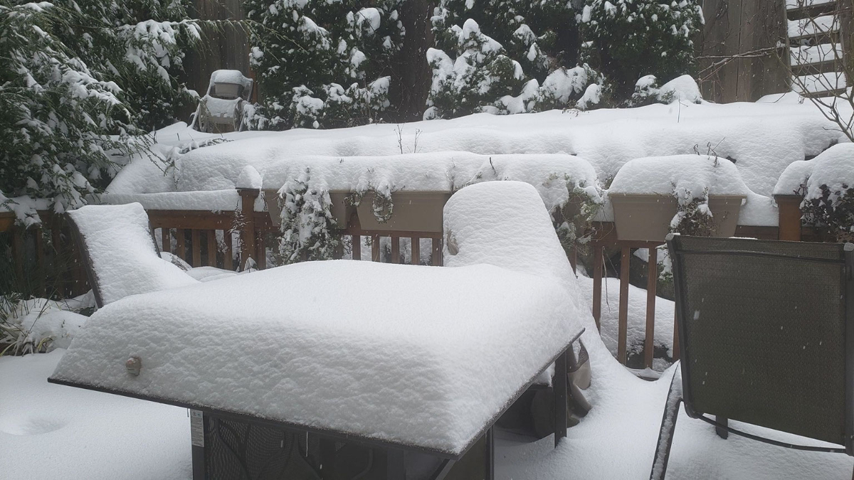
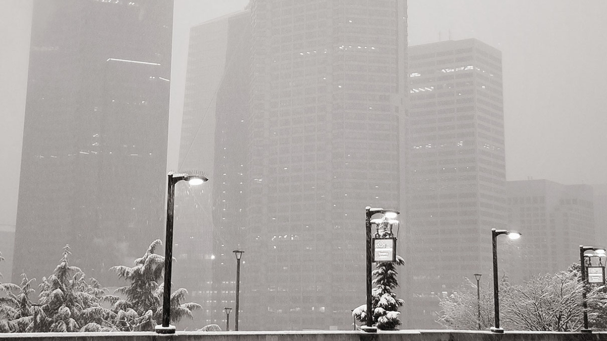
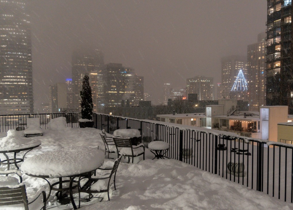
[SEATTLE] – (MTN) Puget Sound woke up to five to twelve inches of snow with more coming down on Saturday, as the biggest winter storm in two years blanketed the region. Light snow started falling between 6 PM and 8 PM in the Seattle-Bellevue area, while heavier snow accumulated in the South Sound. A third storm system is on tap for Saturday night and Sunday.
Snow showers from the current system are tapering off after a Convergence Zone formed from Marysville to Issaquah this afternoon. Saturday night, snow showers will increase again and get heavier into Sunday morning. By noon tomorrow, most areas will transition to a rain-snow mix or rain, but not before one to three more inches is added to current accumulations. Lows tonight will be 28 to 30 degrees and highs tomorrow will reach 35 to 37.
Many side streets are treacherous or impassable due to snow and ice throughout the region. During the early morning, hours on Saturday I-5 and I-405 were completely snow-covered, measured in inches in some location. Winds howled through the night with gusts as high as 40 MPH. Seattle-Tacoma International Airport had sustained winds of 25 MPH overnight, and wind chill as low as 10 degrees. In Kirkland, Seattle, and other communities, city officials closed numerous streets due to extreme conditions and the danger hills presented to drivers. Officials are appealing for people to stay off the roads if possible.
Further south in Tacoma and Olympia, 9 to 12 inches of snow fell bringing traffic to a standstill. I-5 was littered with accidents overnight in the metro Tacoma area despite light traffic, with emergency crews struggling to cover multiple crash scenes. Clark County where Vancouver is located has declared a state of emergency where roads are impassable. Portland, Oregon saw a wide range of snowfall amounts from 2 to 11 inches, with 6 inches in the city, as many areas experienced a major ice storm. Governor Kate Brown has declared a state of emergency in nine Oregon Counties due to ice accumulations, power outages, tree, and property damage. Over 130,000 people are without power in the hard-hit areas.
Monday will see temperatures approach 40 degrees with a transition to all rain. Side streets will remain a challenge in places likely into Tuesday as the snow gets converted into thick slush.
You can join us on Twitch, no subscription required at malcontentnews.tv We will start our feed between 9 PM and 10 PM PST, depending on the weather.
We will do storm updates as a live blog on this story
Saturday 11:35 AM – Snow is starting to taper off in our area. Temperatures are 27 to 29 degrees and there is very light snow or light freezing drizzle falling through the area. Another inch of snow is possible before tapering off, but it will be short lived. We have another shot of snow coming tonight into Sunday morning, with 2 to 3 inches likely in our area before it transitions to a rain or rain-snow mix. Roads are in poor condition. I-5 and i-405 are in much better shape than they were at 4 AM. The region received 5 to 12 inches last night. Shoreline was reporting 10 inches, downtown Seattle 6 inches, and in the Kirkland-Bellevue-Woodinville area reports are coming in of 6 to 9 inches of snow. You can watch our video from last night to see how bad it was at 4 AM.
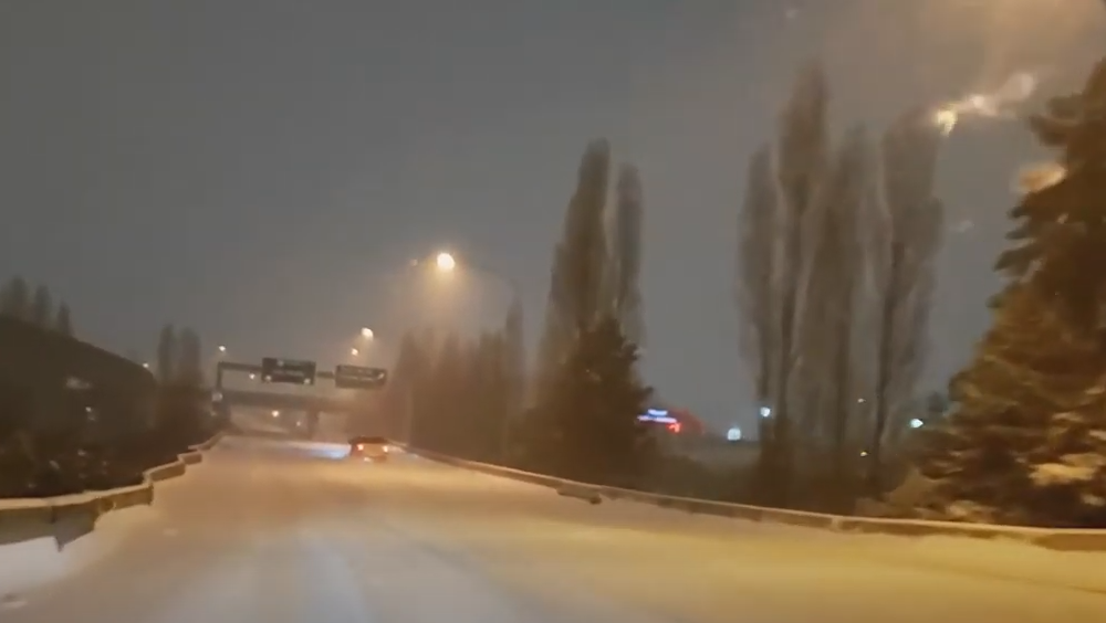
Saturday 4:15 AM – I-5 from Tacoma to Boeing Field has deep snow on it with large sections untreated. I-5 in Auburn and Federal Way is in extremely poor condition, as are the roads in Tacoma. I-5, I-90, I-405, and SH-520 are all snow-covered. There are numerous road closures in Kirkland due to snow and ice build-up on roads. Along the waterfront, the wind is blowing in excess of 20 MPH creating reduced visibility and drifting snow. Snowfall rates are an inch an hour or more, and public works along with state DOT simply can’t keep up. Lake Shore Blvd has waves of snow and tire tracks of cars that pass through disappear within minutes. Many places in Kirkland have 3 to 4 inches of snow already with the heaviest snow bands arriving now. Temperatures are 24 to 26 degrees and the wind chill is 12 to 15 degrees. If you have travel plans tomorrow, especially before noon, we strongly advise you cancel them. Sections of I-5 from Lewis-McChord to Federal Way are the worst I have seen in 21 years of living in this area.
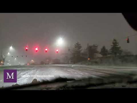
Saturday 12:45 AM – Moderate to heavy snow is falling throughout the Seattle-Bellevue-Tacoma area. Road conditions on I-5 have gotten much worse between Olympia and Tacoma and are fully snow-covered. I-705 to City Center is treacherous and at Woodbridge Ave we came across numerous vehicles unable to navigate the uphill ramp along the Ruston waterfront. Wind chills are from 10 to 15 degrees and moderate to heavy snow will continue through the overnight. We measured 7″ of snow just outside of the Capitol complex in Olympia, and 4″ in Tacoma along Ruston.
Friday 11:15 PM – Road conditions are rapidly deteriorating through the Puget Sound region, especially from Tacoma south. Conditions will get worse across all of Puget Sound as the night continues. In Olympia, there is already 4 to 6 inches of snow on the ground with moderate snow and 28 degrees. Snow now extends across the entire region into Canada, with a wintery mix along the coast. Seattle-Tacoma International Airport is down to 25 degrees with winds of 24 MPH! The wind chill is down to 10 degrees. From Dupont to Olympia I-5 is in poor shape, snow-covered and icy. There were multiple accidents all through Tacoma. There is still a battle between the dry air to the east and the moisture coming off of the coast. Regions west of I-405 in our immediate area will get less snow, but don’t be surprised to see 3 inches fall by morning and another 2 inches on Saturday.
LIVE STREAM COVERING WINTER STORM 2021
Friday 7:26 PM – Seattle-Tacoma International Airport is reporting light snow, visibility of 3 miles, 27 degrees, and an east wind of 10 MPH with gusts of 24 MPH. That puts the wind chill at 17 degrees. Tacoma (at Tacoma Narrows Airport) is reporting light snow, visibility of 2 miles, 25 degrees, and a north wind of 9 MPH. That puts the wind chill at 16 degrees. Snow will continue to get heavier moving south to north. It could be worse, Portland, Oregon is 27 degrees with mixed freezing rain and snow. The winds are blowing from the east at 25 MPH creating a wind chill of 12 degrees!
Friday 6:25 PM – The easterlies are collapsing and combined with the arrival of sunset area temperatures have dropped into the high 20s. Winds are coming from the south and southwest, although if you got 20 miles north of Kirkland, the winds are still flowing from the east. There is a distinct line between the dry air and the moist air flowing in. By 6:00 PM all areas of Kirkland have light snow falling. They are fine flakes but they are already sticking to the pavement. Snow extends north almost to Everett and will continue to expand and intensify. Snow arrived 4 hours earlier than the forecast models. Buckle up Kirkland, it’s going to be very white tomorrow morning.
Friday 5:07 PM – Snowing in Bridle Trails area of Kirkland
Friday 2:24 PM – Easterly flow has kicked in and shredded the snow advancing on the central Sound. Now the 2″ versus 6″ question – how strong will that easterly flow be and how long it will last? We’ll have to see.
Friday 1:22 PM – Snow has reached Federal Way, Washington – if the current northward movement continues, it will be snowing in Seattle-Bellevue around 4 PM
Friday 11:41 AM – Snow has reached Olympia, Washington
[Seattle] – (MTN) A Winter Storm Warning is in effect from 10 PM Friday to 4 PM Saturday, for the most significant snowstorm since February 2019. Warnings extend from Snohomish County to the Oregon border, where the Puget Sound lowlands can expect considerable snowfall.
For the Kirkland-Bellevue-Woodinville area, snow will arrive between 8 PM and 10 PM and steadily increase during the overnight hours. The snow will be moving up from the south, where snow is already falling. Areas east of I-405 and north of SH-520 will get less snow overall.
Most areas received 1/2 to 1 inch of snow overnight in the Kirkland-Bellevue-Woodinville area. An inch of snow is possible on Friday. Overnight, the region can expect 4 to 6 inches of additional snow through Saturday afternoon.
Winds will increase to up to 40 MPH overnight, with temperatures in the 20s, creating dangerous wind chills and blowing snow that will reduce visibility. Travel overnight will be difficult and is already challenging in the Portland, Oregon area.
The one wildcard in this is the easterly winds coming off of the Cascades. We’ve had several forecasted snowstorms shredded by easterlies, which dries out the air and creates a “rain shield” over the Cascade foothills that can extend to Seattle. If the flow becomes strong, it will reduce the snowfall forecast.
With wind gusts forecasted to 40 MPH, areas that are prone to power outages should make sure to have candles and batteries ready. Grilles, portable gas heaters, and generators should never be run indoors due to carbon monoxide poisoning risk. If you lose power in cold weather, setting your faucets to a slow trickle or drip will help prevent pipes from freezing.
How to use up those french toast supplies you over bought
FindACOVIDShot.org helps vulnerable populations navigate the maze to get a COVID vaccination appointment
Sharla (she asked for her last name to be withheld) is in a vulnerable group for contracting COVID and suffering serious symptoms, and she was excited to learn vaccinations would be available. She quickly learned that the path to finding an appointment was full of challenges and barriers. Instead of getting frustrated, Sharla and her brother Steve got motivated. They created a Facebook Group, Find a COVID Shot WA, and assembled a group of volunteers to help others find appointments
A week later, the group had over 10,000 members and is serving the people of Washington state in 10 different languages. The group doesn’t exist to provide insider information or help those not eligible for a shot to find one, but to help those who can’t navigate the system, find an appointment.
The effort to vaccinate Washington state residents is very complicated. There is no central website or location to make an appointment. Each hospital system, pharmacy chain, and medical clinics have their own appointment systems that use different software. Available slots aren’t posted at a set time and can be filled faster than a person can input all the required information. For people who don’t speak English, lack technology, or don’t understand technology like the elderly, the barriers make finding a shot impossible.
Steve and Sharla now have over 15,000 members and have been featured on NPR and local news affiliates. Their success is getting noticed, and they are considering expanding their efforts to other states.
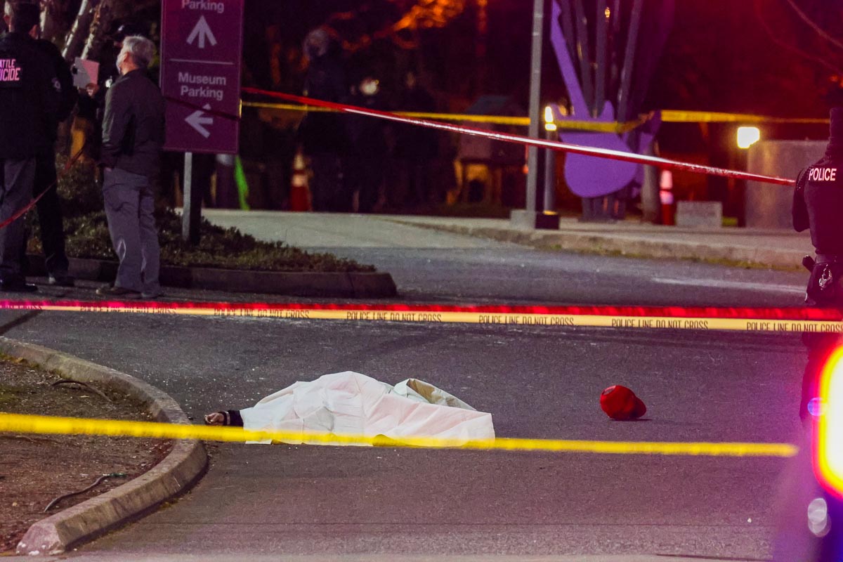
[SEATTLE] – (MTN) The Seattle Police Department has released a heavily edited video from the shooting incident by Jimi Hendrix Park last night. Yesterday evening around 9:15 PM, 911 started receiving calls for shots fired in the 2300 block of Massachusetts Street, by the Urban League Village Apartments. As police arrived they heard gunfire and held their position to wait for more units to arrive. According to the Seattle Police Department, they were confronted by an armed man who fires at the police, and officers returned fire. During this period, 911 received a phone call from a woman reporting that she and her friend had been shot, and her friend was dying after being shot in the face three times. They reported they did not know their location, but 911 dispatch had identified it in the call as the 2300 block of Massachusetts Street. One woman died, the other is in critical condition, and the gunman was declared dead at the scene.
This video contains graphic scenes and descriptions of violence, viewer discretion is advised
The heavily edited video raises questions on the police account of the incident. The video shows two points of view. One from a group of heavily armed officers, who repeatedly order the gunman to put their gun down. There is suddenly a hail of semi-automatic gunfire from sidearms and rifles. A second body cam video from a closer perspective shows the gunman emerging from a driveway and raising his weapon toward police, but it does not appear to show the gunman firing at officers. The gunman has been identified by multiple sources as Gregory Taylor, who was a resident of the apartments.
The conduct of 911 operators will likely be called into question by the community. The woman caller repeats that her friend is dying and she doesn’t know her location. The first dispatcher sounds exasperated as he connects the Seattle Fire Department to the call before asking for other basic information.
[Best_Wordpress_Gallery id=”23″ gal_title=”Jimi Hendrix Park Shooting”]
Protesters marched in Seattle tonight and dropped two banners over an overpass condemning Seattle Police actions. Later, protesters gathered outside of the East Precinct on Capitol Hill in a familiar scene, creating chalk art on the temporary wall. Seattle Police appear to have made one arrest during that protest.
The snowstorm arriving on Friday could be the biggest event since February 3, 2019, when the Super Bowl storm blanketed the central lowlands. Cold air is spilling into Puget Sound from British Columbia tonight and will be entrenched at least until Monday, just in time for thee systems to pass through the area.
Malcontent News is issuing a French Toast Emergency for Friday
The first system is arriving on Thursday, and for the Seattle-Bellevue area will be a non-event. The day will start cold with the first hard freeze this winter season. Temperatures will be 23 to 26 before getting to 34 to 36 degrees. .Seattle should see a cloudy day with a slim chance of a few flakes in the afternoon but no accumulation. Further south, Tacoma is forecasted to receive 1 to 3 inches and Portland, Oregon 3 to 5 inches.
Friday is the main event, with the entire region poised to receive significant snow. The storm will move in from the south. For Portland, Oregon, the two systems will arrive back-to-back with almost no break. For the Seattle-Bellevue area, snow will arrive between 11 AM and 1 PM and continue to spread northward. Portland, Oregon, is poised for a significant storm, with snow totals of 10 to 14 inches. Tacoma will receive 7 to 10 inches, and the Seattle-Bellevue area 5 to 8 inches.
Our hyperlocal forecast for Kirkland-Bellevue-Woodinville projects 5 inches of snow in Woodinville, Kenmore, Juanita, Finn Hill, Kingsgate, and along the downtown waterfront. Rose Hill and the Houghton Highlands should expect 6 inches of snow, and Bridle Trails should expect 7 inches. Downtown Bellevue will see 5 to 6 inches of snow and amounts increasing as you head south toward Factoria. Crossroads in Bellevue should expect 7 inches. Slightly smaller totals should be expected in the northeast corner of Woodinville.
Saturday will see more snow with an additional 1 to 3 inches for the Seattle-Bellevue region before ending around 1 PM. Tacoma will see another 2 to 4 inches ending around 3 PM. Portland will transition to rain in the afternoon for a few hours before changing back to snow after sunset. The system should start to move out of the Rose City by 8 PM on Saturday.
Travel will be difficult through the entire region along the I-5 corridor and over the mountain passes. In Portland, winds of 20 to 30 MPH, with higher gusts, will create dangerous conditions. Travel on I-84 on the Oregon side and SH-14 on the Washington side of the Columbia River may be near impossible where winds could top 45 MPH.
Sunday into Monday, a third system will arrive. The weather models have very little agreement on what will fall from the sky on Sunday afternoon. Temperatures will be warmer than Saturday but still below average. There is the potential for more snow, but a sloppy wintery mix of snow, sleet, and freezing rain looks more likely. What and how much will depend on the storm track and elevation creating a very challenging weather forecast.
What to do with the leftover milk, bread, and eggs you horded
[SEATTLE] – (MTN) One woman is dead, and another is fighting for her life after being shot last night. Seattle police received 911 calls about shots being fired in the 2300 block of Massachusetts Street, adjacent to the African American Heritage Museum and Cultural Center by Jimi Hendrix Park.
A Seattle police spokeswoman stated that the police heard gunfire upon arrival and waited for additional units to arrive before advancing into the scene. According to witnesses, including those we spoke to, they saw a gunman firing multiple shots. One individual stated Seattle police “swarmed” an armed person and shot him. Seattle police claim there was an exchange of gunfire with the suspect, who was hit multiple times.
[Best_Wordpress_Gallery id=”22″ gal_title=”Jimi Hendrix Park Shooting”]
Officers secured the scene and found two shooting victims about a block away in a vehicle. Both women were transferred to Harborview Medical Center, where one remains in critical condition. The other woman died from multiple gunshot wounds while in transit to the hospital.
Multiple people have identified the person shot by Seattle police as Gregory Taylor. Seattle police stated that Taylor knew the two shooting victims and that this was not a random attack. Taylor’s next of kin was notified at the shooting scene shortly after arriving
After the shooting, several protesters arrived at the scene, which police had secured. Family members and others asked through social media for the protesters to leave. A small memorial was set up in Jimi Hendrix Park with candles and chalk art.
Tensions between the Seattle Police Department and the public are high after months of social justice protests, motivated by George Floyd’s death. The Seattle police have had to walk back claims of IEDs used by protesters, untrue accusations of extortion in CHOP over the summer, and multiple uses of force claims against the department. Since Adrian Diaz has become the Acting Chief, four officers have been fired for violating department policy. These incidents have worked against community trust, along with an extensive history of biased policing in BIPOC neighborhoods. The Seattle Police Department has been operating under a federal consent decree for almost a decade.
The Force Investigation Team is investigating the officer-involved shooting. On their blog, Seattle police stated they would release body cam video within 72 hours, per department policy.
[SEATTLE] – (MTN) Yesterday, Magistrate Judge Brian Tsuchida or Seattle caused a stir when he issued a court order that would release Proud Boy Ethan Nordean, also known as Rufio Panman, from federal custody to await trial. An emergency stay by Chief U.S. District Court Judge Beryl Howell kept Nordean in custody. The self-proclaimed Sergeant of Arms for the Proud Boys will be held in custody, awaiting transfer to Washington D.C.
Ethan Nordean’s family owns Wally’s Chowder House in Des Moines, Washington, a local icon for seafood in the South Sound. After Ethan Nordean was arrested, his father Mike Nordean released the following statement, “We have tried for a long while to get our son off the path which led to his arrest today – to no avail. Ethan will be held accountable for his actions.” In June of 2020, the elder Nordean released a statement indicating they had fired Ethan from Wally’s Chowder House and ended supporting their son. However, court records paint a different picture.
In arguing against the release of Ethan Nordean, federal prosecutors indicated that he lives rent-free in a home provided to him by his parents and has no financial obligations that would keep him in Puget Sound. Given his connections and documented role in the insurrection, the move to release Nordean becomes more puzzling. Ethan was witnessed leading a contingent of Proud Boys down Constitution Avenue while Donald Trump was finishing his speech, and leading the charge against the pedestrian barricades at the Capitol.
Ethan Nordean will have his next hearing in Washington D.C. on February 15, 2021.
UPDATE: Please read our updated story by clicking this link
[SEATTLE] – (MTN) The Seattle police department has reported an officer-involved shooting in the 2300 block of Massachusetts Street, adjacent to the African American Heritage Museum and Cultural Center. There are multiple officers on the scene and images from an independent journalist show a body draped in a sheet on the ground behind crime scene tape.
A Seattle Public Information Officer stated that Seattle Police were responding to 911 reports of shots fired in the area at 9:15 PM. When police arrived at the African American Heritage Museum and Cultural Center they heard shots being fired. Officers moved in and witnessed a single suspect, who the public information officer states fired at the officers. Multiple Seattle police officers returned fire, striking the suspect, who died on the scene. The person shot by Seattle police has been identified, but we have chosen to withhold the name at this time.
Officers found two additional shooting victims in an adjacent parking lot who had been shot multiple times. Both have been transferred to the hospital with life-threatening injuries. Q13 Fox is reporting that one female is at Harborview in critical condition. The two shooting victims were shot by the suspect according to Seattle police. Seattle police report that they believe that the assailant and the two victims knew each other, and this was not a random shooting.
Seattle Police were responding to some kind of disturbance or report in the area, and a single officer is reported to have been involved in the shooting. Multiple reports on social media are indicating the person shot is a resident of the Urban League
Malcontent News has a team member en route and the Seattle Police Department is reporting that a Public Information Officer will be available for questions. This is a breaking news situation and we will provide updates.
A series of three storm systems are bringing snow to the Seattle area from Thursday to Monday. The storm systems will be passing to the south of Seattle, bringing the heaviest snow to Tacoma and through southwest Washington, and further south to Portland, Oregon. The Seattle area could see 4 to 8 inches of snow from Thursday to Saturday, Tacoma 8 to 12 inches, and Portland, Oregon, 14 to 18 inches.
The National Weather Service has posted a Winter Storm Watch for Pierce County and points south, with the potential for up to 8 inches of snow in the Tacoma area on Thursday and into Friday morning. Lesser amounts will fall in Seattle and Bellevue. Temperature models have moderated from earlier this week. The urban core of the Puget Sound lowlands will still experience a hard freeze starting Wednesday night.
Closer to our local area, Wednesday will be mostly cloudy for the Kirkland-Bellevue-Woodinville area, with a high temperature of 39 to 42 degrees. Wednesday night will have cloudy skies, and temperatures will drop to 23 to 26.
Thursday will see snow moving into the area from the south. Models indicate snow will arrive in the Seattle area from 11 AM to 1 PM and increase to a peak during the evening commute. Light snow will continue into Friday morning, with this event bringing 2 to 4 inches to our region. Areas south of Kirkland and Shoreline will get more snow, increasing significantly south of Federal Way. The high will only get to 33, so this will be a snow event for everyone.
Thursday night temperatures will drop back into the mid-20s, and Friday will struggle to get above 30 degrees with some sunbreaks. The next round of snow is the strongest of the three systems. It will arrive between midnight and 2 AM on Saturday with 2 to 4 inches of snow in the Kirkland-Bellevue-Woodinville area tapering off in the early afternoon. Like all three systems, the further south you go, the more snow in the models, with Vancouver and Portland seeing 8 to 12 inches from this system.
A third system will arrive on Sunday night. This one is too far out to forecast with accuracy, but models indicate this will pass closer to the Seattle area. Temperatures are on the edge of supporting snow, so it is possible for a wintery mix before a transition to rain on Monday morning.
Kirkland-Bellevue-Woodinville residents should plan for 4 to 8 inches of snow between Thursday and Saturday, with very little melting between each day. Sunday’s models are indicating a more significant event with 3 to 5 inches possible. For now, you should stay tuned.
If your weekend travel plans including heading south on I-5 or crossing the mountain passes, particularly Snoqualmie, you should have a winter survival kit in your vehicle. That includes tire chains as required and crossing the pass with a full gas tank (or battery charge). Travel south of Olympia could be very challenging on Friday.
Journalists, activists, and researchers defending the First Amendment
Subscribe to Malcontent News
Register to feed your head holes with the Malcontent News newsletter.
Submitting your e-mail address gives us permission to send you e-mails. We do not sell or distribute our e-mail lists or share them with third parties.