[WBHG News – Kirkland, WA] Puget Sound Energy reported almost 39,000 customers were without power after a late morning windstorm moved through Puget Sound. Whidbey Island was the hardest hit, with scattered outages reported in Kirkland, Bellevue, Sammamish, Mercer Island, and Bainbridge Island.
Sustained winds at Paine Field in Everett reached 30 MPH with gusts to 56 MPH. At Seatac International Airport, a gust of 47 MPH was recorded. At the storm’s peak, over 64,000 homes and businesses were without power. Trees weakened by the November 19 windstorm, which knocked out power in some areas for a week, were toppled across the region.
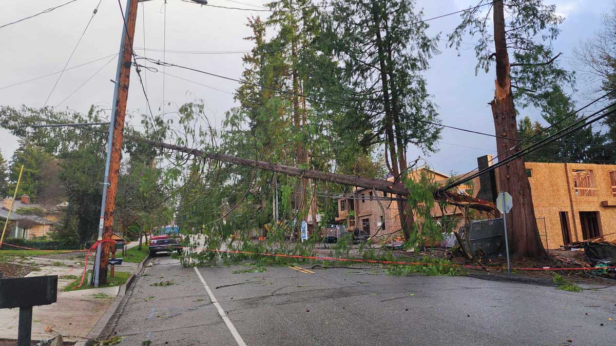
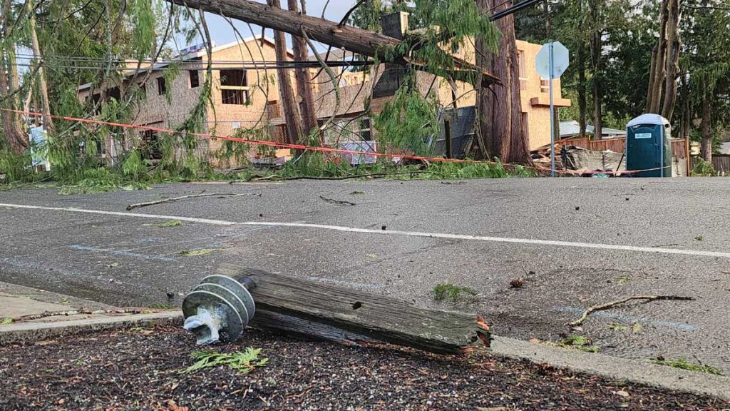
December 14, 2024 – Downed trees tore down powerlines and damaged electrical infrastructure in Kirkland, Washington. Photo credit – David Obelcz
In Kirkland, NE 112th Street was blocked by a down tree, which damaged utility poles, power lines, and Internet cables. Kirkland police had blocked off the area. At the time of publication, Puget Sound Energy’s outage map indicated that many ongoing outages should have been resolved between 1 PM and 5 PM but did not have crews assigned.
[WBHG News 24 – Kirkland, WA] – The Washington State Patrol shared a picture of a vehicle that went around construction barriers on I-405 and drove into the ongoing roadworks at the Exit 18 bus terminal and highway interchange expansion project. No one was injured.
According to Washington State Patrol Trooper Rick Johnson, the driver of the Subaru SUV went around the construction barriers, continued southbound on the Exit 18 offramp, and drove into the construction area. The driver was not impaired, and Trooper Johnson alleged the driver said they “forgot” there was a road closure. It is unclear how they drove around the barriers.
The Washington State Department of Transportation, King County, and the City of Kirkland had previously announced that parts of Northeast 85th Street and the I-405, Northeast 85th Street Interchange would be closed from January 26 to 29 to demolish the off-ramp bridges at I-405 and Northeast 85th Street. A second set of closures is planned for February 2 to 5 to replace the existing infrastructure with new four-lane intersections.
The picture shows skid marks leading to the dropoff and a piece of construction equipment well below where the car stopped, suggesting the accident could have been more serious.
The most recent data from Washington state about construction zone accidents is from 2021, which posted a 10.8 percent increase over 2020, with accidents in interstate construction zones increasing by 15.4 percent. Both years had significantly reduced traffic due to the COVID-19 pandemic and work-from-home mandates. The biggest increases were among rear-ending accidents and crashes involving commercial vehicles, with fatal work zone accidents increasing by 18 percent. There was no data available on accidents caused by drivers who wilfully ignore road closures.
[WBHG News 24 – Kirkland, WA] – Seattle temperatures rose above freezing for the first time in 89 hours on Monday, but a sloppy weather system is poised to bring snow, sleet, and freezing rain to the Puget Sound lowlands on Tuesday night.
During the evening commute, precipitation will arrive in Puget Sound, rapidly spreading. From Tacoma north, expect snow and sleet before a transition to freezing rain and rain.
Focusing on our forecast area of eastern Puget Sound – Kirkland, Bellevue, Bothell, Kenmore, Redmond, and Woodinville – snow will be falling across the entire region by 7 PM. Up to 1/2 an inch of wet accumulation is possible before the transition begins. Higher hills and along the King-Snohomish County line may see a little more.
Between 8 PM and 10 PM on Tuesday, the snow and sleet will transition to freezing rain and rain. Up to 1/10 of an inch of accumulation is possible on the east side of central Puget Sound, but there is a lot of disagreement in the forecast models. We’re forecasting a transition between 1 AM and 3 AM on Wednesday morning, but keeping an eye on the situation.
The center of Seattle will have a mostly rain event, with the line between rain and a period of freezing rain roughly in the middle of Lake Washington. Kenmore and Northgate will also be in the area of freezing rain. If you’re driving east from Seattle on I-90, you may enter the tunnel on Mercer Island with it raining and exit the other side into freezing rain!
The Euro, which is the best model for predicting winter weather in our area is forecasting a transition between 5 AM and 7 AM. If this model is correct, the Wednesday morning commute will be even more challenging.
You should put off any travel on Tuesday after the evening commute, especially during the overnight hours. Low traffic and convective cooling will accelerate ice build-up on ramps, bridges, and side roads. If you have to drive, give yourself plenty of extra time, route around hills, leave extra room between you and other vehicles, and plan ahead as you approach traffic lights and stop signs.
[KIRKLAND, Wash.] – (MTN) The National Weather Service has issued a Heat Advisory from noon Wednesday to midnight Thursday for Western Washington, with temperatures expected to flirt with the 90-degree mark. Seattle set a record for the most days in a year over 90 degrees and tied the record for the most days at or over 95 degrees in a year earlier this month.
It isn’t all bad news if you’re not a warm weather fan. The region has crossed over the point where 100 degrees are highly unlikely and inching closer to where 90-degree heat will be in the rearview mirror. So far, 2022 has been almost smoke-free. Air quality flirted with moderately unhealthy last week, with one afternoon providing orange-tinged afternoon light due to a layer of high-altitude smoke. Keen noses might have noticed the smell of smoke in the air on Monday evening.
Rest of Today
The afternoon will be pleasant for most, while old-school eastsiders might find it too warm. High temperatures will be 82 to 86 degrees under clear skies with winds from 5 to 10 MPH.
Tuesday Night
Temperatures will be pleasant, providing perfect sleeping with a low of 58 to 61 degrees.
Wednesday
Clouds may roll in and help moderate temperatures, making it difficult to break the 90-degree barrier. In the Bellevue-Kirkland-Woodinville area, highs will be 87 to 91 degrees under clear skies, with a light onshore flow forming toward the end of the day. Clouds will start to move in near sunset.
Wednesday Night
Partly to mostly cloudy skies will act like a blanket, while a weak onshore flow will hold back temperatures from dropping after sunset. Area lows will be 63 to 67. The onshore flow will shift overnight, causing humidity to climb.
Thursday
Partly to mostly cloudy skies won’t stop the mercury from climbing. Thursday morning will have the “it is going to be a hot day” feel as you head out the door. High temperatures will be 88 to 93 degrees. The dew point will be 63 to 65, which isn’t terrible, but will make the air feel a touch sticky.
Thursday Night
Cloud cover will once again act like a blanket that holds in the day’s heat. Low temperatures will be 63 to 66.
Friday Outlook
Friday and the rest of the weekend look to be partly cloudy, with highs in the 70s and 80s and pleasant sleeping weather returning.
[KIRKLAND, Wash.] On Saturday, August 13, 2022, a suspect was arrested in California in connection with a violent domestic assault.
On July 29, 2022, a Kirkland resident was assaulted by a vehicle in the parking lot of a retail store in a neighboring town. Following the attack, the Kirkland resident was repeatedly victimized by the suspect, who made unwanted phone calls threatening to kill the victim and the victim’s children.
The KPD Domestic Violence (DV) Unit assisted the victim and their family with temporary safe housing, Domestic Violence Advocacy services, and increased patrols of the victim’s residence as the suspect.
Detectives with KPD learned that the suspect had fled to Bakersfield, California, and coordinated with officials in the region to locate the suspect. The Tulare County Sheriff’s Office gang and narcotics enforcement unit arrested the suspect under a felony warrant issued by the King County Prosecutor’s Office.
The suspect is unnamed at this time and is awaiting extradition back to Washington.
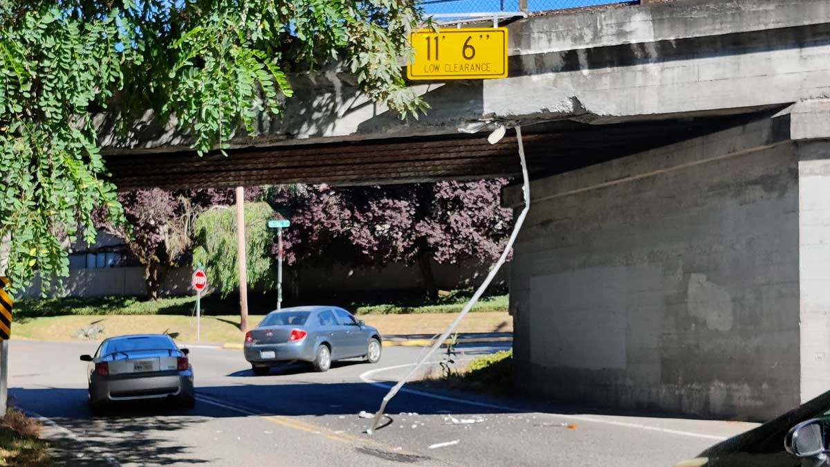
[KIRKLAND, Wash.] – MTN The infamous truck-eating bridge didn’t quite claim another victim but may be a victim itself after a significant bridge strike where the driver left the scene.
Around 4:30 PM on Saturday, a truck heading “eastbound” toward 85th Avenue struck the bridge, causing moderate damage to the concrete, exposing the supporting rebar, and sending at least one section of conduit into the road. The roadway is littered with concrete pieces. The truck drove off after the strike with unknown but likely significant damage.
This is a breaking news story and we will provide an update as more information becomes available.
[KIRKLAND, Wash.] – (MTN) The National Weather Service has issued a Heat Advisory from noon Sunday to 9 PM Monday for Western Washington, with temperatures expected to flirt with the 90-degree mark. Smoke is expected to roll into the region and linger through Tuesday.
Saturday Night
Saturday evening will be pleasant with a northwest breeze from 5 to 10 MPH. Temperatures will be perfect for sleeping – 56 to 60 degrees.
Sunday
Sunny skies with light winds will heat things up with highs reaching 88 to 92 degrees. Temperatures will be cooler by the water and hotter in urban canyons and our area hot spots like Totem Lake and Kingsgate. An onshore flow will develop, pulling smoke over the Cascades. The AQI will be moderately unhealthy, 51 to 100 PM2.5. Very sensitive groups should limit their time outdoors and avoid strenuous activity. Photographers will want to have their cameras ready for a brilliant sunset.
Sunday Night
Temperatures will drop to 57 to 61 degrees, and smoke will remain moderately unhealthy, with the AQI between 51 and 100. Smoke tends to be worse at night as cooler air sinks and pulls it closer to the ground.
Monday
Monday’s forecast is complex, which makes it tricky. If the smoke becomes denser than current models, it will moderate high temperatures. Cloud cover is expected to move in from a weak disturbance, and that will also impact the high temperature and how much smoke settles in the area. High temperatures will reach 89 to 92 degrees in the Bellevue-Kirkland-Woodinville area, with an AQI of 51 to 100. Clouds aren’t expected to roll in until very late on Tuesday, but if that accelerates, it will moderate temperatures and convert our smoke into smog.
Monday Night
Low temperatures will be 59 to 65 degrees depending on when the clouds arrive and how much smoke is in the area. Expect cooler temperatures if the current weather models hold and warmer temperatures if the area gets blanketed. AQI will remain 51 to 100. By sunrise, winds will shift to an offshore flow, moderating our temperatures and blowing any smoke left out of our region.
Tuesday Outlook
Tuesday will be mostly cloudy, with smoke blowing out of the region. Expect the AQI to move back to normal by the afternoon. High temperatures will be 80 to 85 degrees with a southwest wind increasing to 7 to 10 MPH. On Tuesday night, there is a small chance of some rain showers moving through the area, cleaning the air out and moderating temperatures back into the 70s for Wednesday.
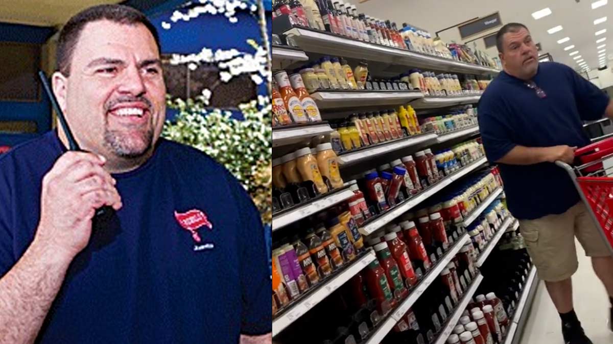
[WASHINGTON] – MTN – A woman is accusing former Juanita High School security guard Jeff Lewis, who was at the center of excessive force allegations in 2013, of voyeurism after she caught him following and video recording underaged girls at Target in Bonney Lake.
A video of TikTok of a woman confronting Lewis on TikTok has received over 900K views.
“You have pictures of children on your phone; that’s not OK. That’s disgusting. You can’t take pictures of underage girls in a store. That’s not OK.”
Lewis tries to walk away, pauses, and says, “you’re wrong.”
The woman says, “I’m not wrong, I saw the whole thing.”
In a follow up video, she explains that she witnessed Lewis filming underaged girls who were in the back-to-school section with his cellphone, taking close-ups of their bottoms and following them through the store. When Lewis realized he was being watched, he stopped filming. The woman approached the girls, asking them if they knew the man, and they stated they did not. She told the girls what was happening and that she would take care of it and make sure they were safe. The girls contacted store security.
The woman who recorded the video shared on TikTok claims that store security was waiting for Lewis when he tried to leave the store, questioned him, and asked to see his cell phone, which he refused. Target said they couldn’t legally detain Lewis, who left the store.
TikTok user @thatdaneshguy, with 1.2 million followers, has created a career in identifying people who commit acts of racism, spread malicious disinformation, and commit child abuse. Danesh and his team identified the man in the video as Jeff Lewis, a former Juanita High School security guard terminated in 2013 due to misconduct.
Lewis was suspended from his job in January 2013 after a 16-year-old student at Juanita High School accused him of causing injury when he manhandled her to the office. After a four-month suspension, Lewis was initially quietly released, causing outrage among area parents and students.
Students mounted a protest in the school with the support of parents, and over 500 signed a petition demanding Lewis be hired back.
The Kirkland Reporter wrote on July 1, 2013, that Lewis had been released after the four-month investigation and was involved in another use of force incident in 2007 when he worked for the Edmonds School District. In a negotiated settlement with Lewis’s attorney, he opted to resign from his position versus being fired “with cause.” The district agreed to pay Lewis’s salary through August 2013 and provide medical benefits through September of the same year. Part of the agreement included purging his employee file of the incident.
“In 2007, Lewis was placed on paid administrative leave during an Edmonds School District investigation, documents state. Lewis was involved in an incident that led to an autistic student’s broken wrist. But after three months of investigating, the Edmonds School District assistant superintendent Ken Limon informed Lewis on Oct. 8, 2007 that based on the information gathered, he did not believe Lewis deliberately or willfully sought to cause the student injury during the physical interaction.”
In that incident, an autistic student at Lynnwood High School had become disobedient and was slapping the teacher when Lewis arrived. After being removed from the classroom, the student allegedly grabbed Lewis and hit him several times. Lewis claims he “gently” pushed the student back to create physical space, and the boy fell, breaking his wrist.
The Lynnwood Police investigated and did not press charges. The Edmonds School District paid a $119,000 settlement to the mother but admitted no wrongdoing.
We have reached out to Target, the Bonney Lake Police Department, Danesh, and the woman who made the video to provide an update to this story.
[KIRKLAND, Wash.] – MTN Juanita Beach is closed for at least one week due to elevated bacteria levels.
Water quality staff from the King County Water and Land Resources Division tested the water on Monday, July 25, and found that the levels of bacteria at the beach exceeded the thresholds for bacteria based on the average of the last three tests. King County crews will return to the beach next week to collect further samples. The beach at Juanita Beach Park will reopen when bacterialevels return to a safe range.
People and pets should not swim, drink lake water, or engage in other water activities at Juanita Beach.
Signs have been positioned to indicate that the beach is closed. City lifeguards will be onsite during the closure to communicate with beachgoers and provide information.
[KIRKLAND, Wash.] – MTN The average summer Western Washington has been enjoying is about to heat up, with a four-day streak of 90-plus degree weather ahead. A thermal trough, high pressure, and light winds will combine to create a classic Washington summer heat wave.
After 2021, the words “heat wave” may bring back bad memories of three days in a row over 100 degrees – it won’t be that hot. Daytime temperatures will cross 90 degrees Tuesday through Friday, while lows will likely stay in the high 60s. Temperatures won’t drop below 70 until close to sunrise, so there won’t be much overnight relief from the heat.
Sunday
A perfect late-July day awaits the Bellevue-Kirkland-Woodinville area. Skies will be mostly sunny with high temperatures between 80 to 84. Some clouds will start to roll in close to sunset.
Sunday Night
Partly cloudy skies with a light breeze from the northeast with a low of 58 to 61 degrees – perfect sleeping weather.
Monday
It warms up a little more, but the area isn’t roasting yet. Morning clouds will burn off, and the high temperatures will reach 84 to 88 degrees.
Monday Night
High pressure will slide down from British Columbia to our north, and a thermal trough will form overnight. Overnight temperatures will fall to 62 to 64 degrees. On Tuesday, things start to heat up.
Tuesday
Clear sunny skies with a light wind from the north and northeast will send temperatures soaring. The high will reach 90 to 93 degrees through the Bellevue-Kirkland-Woodinville area. Downtown Bellevue and Totem Lake will be the hot spots, while Finn Hill and right along the water might not quite get to 90.
Tuesday Night
Temperatures will stay well into the 70s past midnight before falling to 65 to 67 degrees close to sunrise. Thee won’t be much of a breeze to offer any relief.
Wednesday
The week’s hottest day will get even warmer thanks to a weak easterly flow off the Cascades. High temperatures will be 92 to 96 under clear skies.
Wednesday Night
Temperatures once again will stay well past 70 overnight, falling to 65 to 68 degrees close to sunrise. It will be almost windless, so make sure those fans are ready.
Rest of the Week
On Thursday and Friday, the high-pressure center starts to drift slowly, moderating temperatures a little bit. it is too far out to make an accurate forecast, but models support temperatures reaching 90 to 94 on both days, with lows at night falling to 64 to 67. Friday night might be a little cooler as the high-pressure area starts to move out of our region and the thermal trough breaks up.
Due to our unseasonably cold spring and deep snowpack, area rivers, streams, and lakes remain very cold. It is possible to get hypothermia, even on a 90-degree day. Stream flow is also high, so tubers and kayakers should use caution. Currents are faster than usual. Never swim, tube, or boat near downed trees or low head dams, it is very dangerous.
Do not leave pets or children in your car, even for “just a minute.” Temperatures can soar to over 110 degrees in less than 10 minutes, leading to heat stroke or worse.
If local and county officials believe that there is a heat emergency, cooling centers will be opened. King County, Woodinville, and Kirkland opened cooling centers last year, while Bellevue partnered with area businesses.
Regrettably, due to the current COVID BA.5 surge and community spread of monkeypox, people seeking cooler indoor spaces should consider wearing a tight fighting N-95 mask.
Journalists, activists, and researchers defending the First Amendment
Subscribe to Malcontent News
Register to feed your head holes with the Malcontent News newsletter.
Submitting your e-mail address gives us permission to send you e-mails. We do not sell or distribute our e-mail lists or share them with third parties.