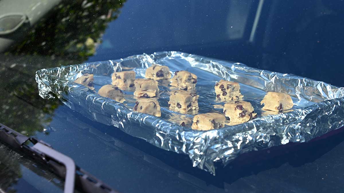
[KIRKLAND] – (MTN) Twitter, YouTube, and Tik Tok were full of videos of people cooking eggs, bacon, pancakes, and cookies on decks, pavement, and in cars. Yesterday we put this to test using our company truck, which had been sitting all day and facing west.
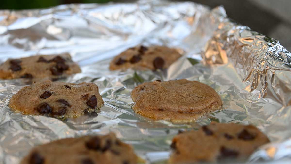
We got off to a late start, putting the cookies into the General Motors built oven at 4:01 PM. We had planned for 2 hours, but many of you suggested we should go for 4 hours. A check at 6:15 PM showed we had a hot mess, as some of you voted. We didn’t open up the door to check because we wanted to retain as much heat as possible.
By 7:30 PM, it was still 108 degrees outside, but the sun had sunk low enough to our west that it was starting to get filtered by trees. The thermometer we put on the dashboard showed the interior had dropped to 140, but the cookies looked – done.
The tops were surprisingly chewy, while the very bottom could have benefited from a bit more heat. That may be our fault because we put a silicone sheet under the baking tray, thinking it would protect the dashboard. After we set up the cookies, we learned a car’s dashboard could get to 200 degrees, so any fears that the heated metal baking tray would damage the vehicle were unfounded.
If you like your cookies soft, these were nearly perfect. If you like your cookies with a crunch, like one of our unofficial testers, these were a nope.
Can you bake cookies in your car on a hot day? Yes, if you like them soft baked. If you’re wondering what the inside of the truck smells like, it smells like a bakery.
[KIRKLAND] – (MTN) The heatwave that roasted the Pacific Northwest isn’t over, with eastern Washington, Oregon, and Idaho facing all-time record highs on Tuesday. For the western side of the Cascades and Siskiyous, things will be closer to normal except the central lowlands and southwestern Washington, where highs will be 15 to 20 degrees above normal.
Here is a list of new all-time records that were set during the heatwave, which continues in eastern Washington and Canada:
Washington All-Time Highs
Richland – 118 degrees June 29, which ties the all-time record high for the state of Washington with Dallesport Airport on June 28 and Ice Harbor Dam, the original record holder
Dallesport Airport reached 118 degrees which tied the all-time record high for the state of Washington
Bellingham – 99 degrees
Hanford – 115 degrees
Hoquiam – 103 degrees
Olympia – 110 degrees
Quillayute – 110 degrees
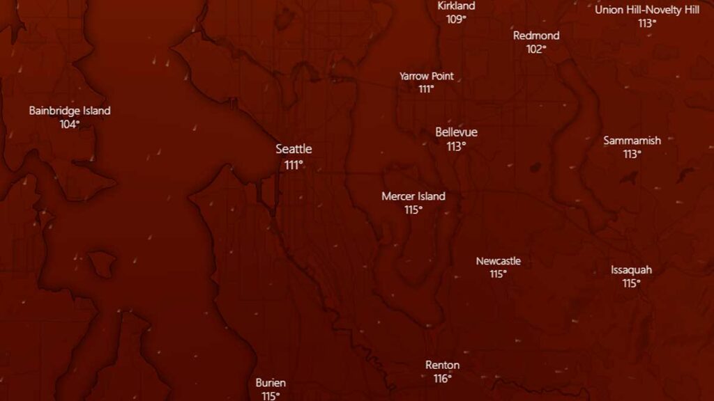
Seattle – 108 degrees
Spokane – 109 degrees June 29
Vancouver – 115 degrees
Oregon
Astoria – 101 degrees (tie)
Corvallis – 110 degrees
Eugene – 111 degrees
Hermiston – 117 degrees June 29
Hillsboro – 114 degrees
Hood River – 109 degrees
McMinnville – 114 degrees
Medford – 115 degrees
Pendleton – 113 degrees
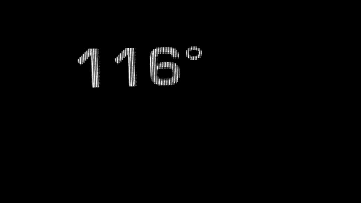
Portland (Airport) – 116 degrees
Redmond – 110 degrees
Roseburg – 114 degrees
Salem, Oregon reached 117 degrees, which is the highest temperature ever recorded west of the Cascade Mountains in Oregon or Washington
Troutdale – 116 degrees
California All-Time Highs
Yreka – 109 degrees (tie)
Sandberg – 107 degrees
Canada All-Time Highs
Lytton, British Columbia set an all-time high of 121 degrees (49.6 C) which is also the highest temperature ever recorded in Canada on June 29, breaking the record set on June 28
Nahanni Bute, Northwest Territories – 101 degrees, which is an all-time record for the Northwest Territory
Tuesday, June 29, 10:15 PM: No further entries to our heatwave 2021 live blog.
Tuesday, June 29, 9:45 PM: What a difference a day makes. Twenty-four hours ago, it was still 100 degrees after the hottest day in Seattle history, with multiple weather records smashed from Canada to California. The marine layer chose violence today and said not today to the heat for the lowlands. SeaTac Airport topped out at 84 degrees, well below the forecast. Our south Juanita weather station came in at 87. Tomorrow will be even cooler, and there is a chance our 80+ degree streak will end.
On the subject of I choose violence, the heatwave did not end for Pacific Northwest or Canada. Multiple weather records were smashed, with Canada recording their highest temperature ever, 49.6 degrees Centigrade, in Lytton, British Columbia. Washington state tied the state record for the hottest spot in state history, with Richland reaching 118 degrees. Two other locations reached 118, including Sol Duc on Tuesday, but we consider that report to be suspect. If you see anyone saying Renton reached 120, that is incorrect – it was an error in recording data.
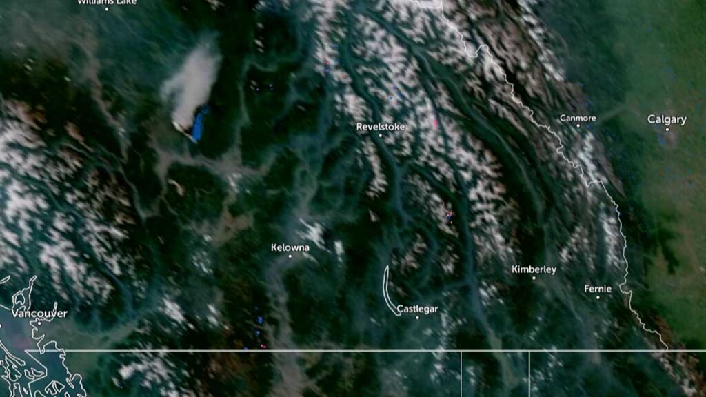
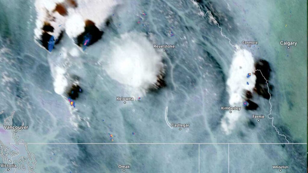
Also, in British Columbia, the province exploded in wildfires today. Here is a satellite image from 2:30 PM today. You can see a plume of wildfire smoke center left, due west of Revelstoke, and a spot of smoke northeast of Kelowna.
British Columbia 2:30 PM Visible Satellite image
This is the image at 6:30 PM today:
British Columbia 6:30 PM Visible Satellite image
Air quality warnings are already posted for parts of British Columbia, but so far, most of this smoke is at higher altitudes. The BC Wildfire Dashboard is reporting 22 new wildfires in the last 48 hours. We will be writing more about the situation north of the border. We would recommend not throwing out those N-95 masks. Washington state is now a change in wind direction away from smoke blowing into our state.
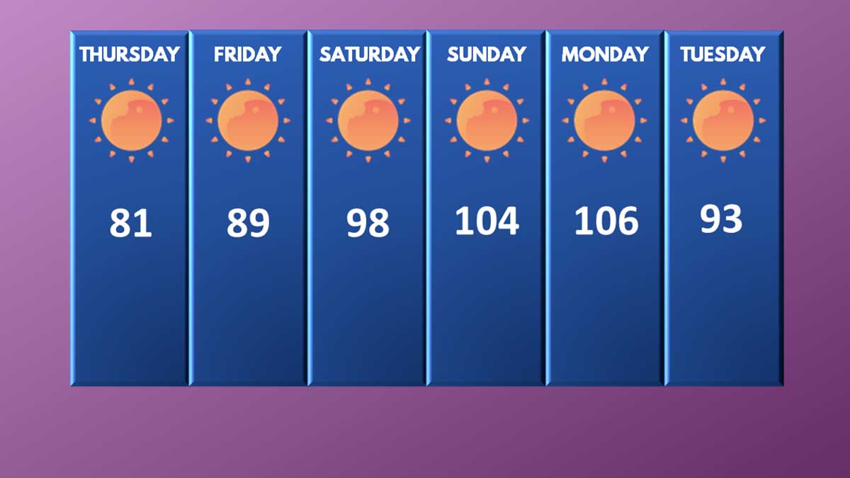
So how did we do against our original forecast from 7 days ago:
Malcontent News original forecast from Wednesday, June 23, 2021
Thursday, June 24: Forecast 81, actual 82
Friday, June 25: Forecast 89, actual 87
Saturday, June 26: Forecast 98, actual 102
Sunday, June 27: Forecast 104, actual 104
Sunday, June 28: Forecast 106, actual 108
Tuesday, June 29: Forecast 93, actual 84
How many times have we said forecasting beyond five days is throwing darts – a lot! I’ll close out this entry saying we feel we served our community well with accurate forecasts and up-to-date information.
Tuesday, June 29, 9:45 AM: This will be our second to last entry in the heatwave blog, barring some major news events related to the heatwave.
Last night the temperature at KSEA dropped 36 degrees in 3 hours as a south wind signaled the arrival of marine air into Puget Sound. The drop in temperature was pretty amazing:
10:00 PM – 98 degrees
11:00 PM – 82 degrees
12:00 AM – 71 degrees
1:00 AM – 66 degrees
2:00 AM – 64 degrees
3:00 AM – 63 degrees
4:00 AM – 62 degrees
The marine layer even made things mostly cloudy for some areas in Puget Sound, including SeaTac Airport. In contrast, on Sunday night it was 81 degrees at 3:00 AM!
The high pressure system continues to drift eastward slowly, and the lowlands will still be hot today. Our weather station bottomed out at 65 degrees, so our forecast was off by 4 degrees. The marine air didn’t get quite as entrenched on the eastside so evening temperatures didn’t cool down as quickly. When SeaTac was reporting 71 at midnight, our station was showing 80.
For our “storm chasing” yesterday we actually chose right going to Maple Valley, which wins the distinction of the highest temperature from a NWS recognized temperature source – 118 degrees. Issaquah came in second place at 116. We noted yesterday our station reported 111, but we are in sight of Lake Washington and are just close enough to get some cooling benefits. Totem Lake less than 2 miles away was 114.
The Cedar Hills Fire in Issaquah is still burning and did not grow past 30 acres. Crews worked to contain the lines last night and more resources along with an additional helicopter is being brought in. The cool weather certainly helped.
I’m not feeling completely confident that we’ll reach 91 today and I’m going to tweak the forecast – but the models support it and the models have been very accurate. People with Ph.D next to their name will be studying this heatwave for years to come.
A closing thought. Dismissing what happened as a weather “anomaly” within a few degrees of normal isn’t the correct way to view this. I have written many times, weather is not climate, and climate is not weather. A series of all-time record highs from the Yukon Territory of Canada to Yreka, California does not on its own provide proof of climate change.
In the month of June we have seen:
A historic tornado in the Czech Republic that dropped baseball size hail and killed 5
4 named tropical storms before June 30 – tying the most named storms this early in the season in what appears to be another active hurricane season
Our heatwave coupled with the one starting in the New England states
Drought from Washington to Minnesota to Texas to California that hasn’t been this severe in 1200 years
Massive flooding in Detroit
Some of the biggest snowstorms Australia has seen in decades
That’s is just a short list of global weather extremes pointing to a climate crisis. Human beings can’t live in areas above 50 Centigrade without massive infrastructure. At 50 C the tolerance of our ability to survive declines, and once you get tropical humidity, survival becomes impossible. Going outside, even for healthy people, for hours at a time is dangerous at that temperature. The high temperature in Canada yesterday was 48 C.
In Whatcom County, the blueberries literally cooked on the bushes ruining the upcoming harvest. The choices everyone makes will have a major impact on our future.
P.S. – we will be reporting on the cookies shortly.
Monday, June 28, 10:25 PM: A lot to write about!
Numerous power outages are impacting 10,887 customers across Seattle City Light, Puget Sound Energy, and Snohomish County PUD. The biggest impacted area is between Carkeek Park and the Seattle Golf Club, roughly west of Greenwood Avenue. This impacts 4,500 customers, and power isn’t expected to be restored until 2 PM on Tuesday.
Two lanes are closed on I-5 northbound at milepost 132. A panel of concrete road surface buckled during the start of the heatwave, and the temporary repair has failed. The damaged area started to shed chunks of concrete, forcing the closure. Repairs cannot start until the weather gets cooler.
The Red Flag Warnings for the Cascades were allowed to expire as the Haines Index is declining for the region. However, air quality is expected to decline again tomorrow, and an Air Quality Alert will likely be issued.
The Excessive Heat Warning was allowed to expire for many areas but continues tomorrow for the central lowlands. You can read more in the forecast section. Although marine air arriving and the thermal trough leaving will drop temperatures 15 to 20 degrees from Monday, most locations will be over 90 tomorrow with more humidity.
Because tomorrow is forecasted to be 15 to 20 degrees above normal (versus the 35 to 40 degrees above normal for Kirkland today), Kirkland will have cooling centers open tomorrow.
The Cedar Hills Fire in Issaquah has grown to 30 acres but could be described as “under control.” The state is bringing in more resources tomorrow and a third helicopter. Light winds and lower temperatures will help keep the fire from spreading, and the danger to people, property, and the power transmission lines has been mitigated for the evening.
The city of Bellevue has issued a citywide burn ban, including fires in what would be “approved” metal or concrete fire pits. Only sealed burners on grilles and outdoor gas-powered fireplaces are allowed due to the growing fire danger. The city of Kirkland is mulling over a similar ban.
Monday, June 28, 8:00 PM: 2,930 customers are without power near Eatonville including Northwest Trek. There are now 158 outages impacting 11,757 customers.
Monday, June 28, 7:25 PM: The all-time record high for Seattle is in the books and it came in at 108. Cairo, Egypt was 99 degrees today and Phoenix, Arizona reached 108. Riyadh bested Seattle with a high of 114, but Portland outcooked the Saudi Arabian city with an all-time record high of 116. Relief is coming but tonight will be beyond unpleasant for the 60% to 65% without access to air conditioning. Our south Juanita weather station topped out at 111.4 degrees – so that is 111 in the record books. We were off 3 degrees on our forecast.
Some hotels in Seattle were charging up to $997 a night to escape air conditioning, and we found the Fairmount Olympic charging $717 tonight.
Puget Sound Energy is dealing with 148 outages impacting 9,757 customers. These are mostly equipment failures impacting small clusters of customers. Power has been restored for most customers in Auburn and Lake Tapps.
A lowland wildfire is burning in Issaquah near Maple Valley. The fire started around 1 PM today and aligned with our observations of smoke-tinged haze in the area during our lunch break and gummy bear melting at Arby’s. Eastside Fire & Rescue is reporting the fire burning near Maple Hills Elementary has expanded to 30 acres. A State crew and a helicopter have been brought in to fight the blaze which is very close to major transmission lines.
Seattle has broken or tied 13 weather records in the last 72 hours.
Sound Transit is reporting that light rail will be operating at reduced speeds for at least a few days because the rails are so hot. Riders of light rail should anticipate delays.
Now if you excuse me, I have cookies in the “oven” I need to go check on.
Monday, June 28, 5:05 PM:KOMO is reporting that the city of Bellevue has instituted a citywide total burn ban. This includes “approved outdoor recreational fire pits” that meet code. Only controlled flames such as from gas barbeques or fireplaces are approved. The ban is indefinite due to the increasing fire danger.
Monday, June 28, 4:40 PM: Avoid southbound I-5 north of 130th. The pavement has buckled from the heat resulting in multiple lane closures. We’re surprised it hasn’t happened sooner in the area.
And here we go.. We have some buckled pavement on southbound I-5 at NE 130th St. Two right lanes are currently blocked. IRT is on scene. Please remember to move over, give us space, and slow down! pic.twitter.com/WYrHAomnqi
the pavement has buckled from the heat on interstate 5
Monday, June 28, 4:25 PM: Is it hot enough to cook an egg? The answer is almost. The yolks cooked through on the one we put on the pavement, the whites cooked a little bit along with the yolk in the one we put in a pan we let preheat on the pavement for 15 minutes. We’re now testing to see if you can bake cookies on a 155 degree dashboard of a vehicle that was parked all day.
Can you cook an egg on the pavement or in a pan? almost.
KSEA has reached at least 106 today with about 60 to 90 more minutes of heating before you can say, “that’s all folks.” A west wind has blown for most of the afternoon moderating temperatures that were earlier today, almost certain to break 110 degrees. The push of the cooler marine air got further inland.
However, the hot spot after hours of “storm chasing” today is Kirkland-Bellevue-Woodinville (congrats for the home team) with temperatures from 109 to 114 degrees through the area. Our south Juanita weather station is showing 111 degrees with maybe another degree to go, we’ll see.
Puget Sound Energy is dealing with 139 spot outages impacting 7,658 customers. Large swaths of Auburn, east of SH-167, and Lake Tapps have been without power since 2:30 today.
Snohomish County PUD has asked their customers to conserve electricity and for those with air conditioning to set thermostats to 78 degrees. The utility does not anticipate rolling blackouts or service interruptions, but it is hitting the limits on its capacity.
Marysville has established mandatory emergency water restrictions after a well pump failed, reducing the available water supply for the town. The restrictions are in place until further notice.
Monday, June 28, 3:05 PM: It is egg frying time, maybe. We’ll be trying shortly at the Village at Totem Lake. It appears Bellevue-Kirkland is going to win the heat medal for the day for our region. Multiple local stations are reporting from 109 to 114. We are seeing 113 at Totem Lake Mall, unofficially. SeaTac Airport is up to 106 degrees a new all-time high, despite a cooling west wind.
There is a major power outage in Auburn impacting over 10,000 customers and Snohomish County PUD is asking their 22,000 customers to conserve electricity. We’ll have more a bit later.
Monday, June 28, 12:48 PM: We are storm chasing and in Covington right now where it is 108 degrees. SeaTac Airport hit 102 officially before noon, not only making this our 3rd day in a row over 100 for the first time in history, but the earliest in the day that Seattle has reached both 90 and 100 degrees.
All of the computer models are in solid agreement it will be 110 to 115 today along the I-5 corridor, and that may be too conservative for places like…Covington, which still have 4 hours of heating to go.
It is oppressively hot.
Monday, June 28, 2021, 10:50 AM: It is already 95 degrees at KSEA. In the garden section at Fred Meyer in Totem Lake, all the thermometers were showing 96, and the panel on trashcan by the entrance was so hot it left my hand stinging for 5 minutes.
We are getting ready to go live to storm chase around 11 AM. We’ll be cooking eggs on the pavement, melting Gummy Bears, and more.
Monday, June 28, 2021, 9:07 AM: Well that didn’t take long. Seattle has already set a record high with a northeast wind gusting to 25 MPH. Before 9:00 AM it was 93 degrees, a new record for the day and I’m confident I don’t need to dig into a record book to type this – the hottest it has ever been at 9 AM in Seattle history. Seattle has now tied for the longest streak over 90 degrees in the month of June, which was 3 days.
Monday, June 28, 2021, 8:40 AM: Let’s start off with last night, it was COOLER then Saturday night with a low of 72 degrees. Here are the temperatures last night:
11:00 PM – 85
12:00 AM – 82
1:00 AM – 81
2:00 AM – 81
3:00 AM – 81
4:00 AM – 78
5:00 AM – 72
6:00 AM – 73
7:00 AM – 79
8:00 AM – 90
No, that isn’t a typo. It was 90 degrees at SeaTac Airport at 8:00 AM today. The dewpoint is lower than Saturday or Sunday so it feels nicer out if that is possible. The wind went from calm to northeast at 14 MPH with gusts to 18 and turned on that easterly flow. That’s how big of an impact it will have today.
There are three factors coming together to create this historic heat for much of western Washington and the I-5 corridor.
The center of high pressure is drifting a bit eastward, allowing the thermal trough that was parked on the coast to move east, right along the I-5 corridor. A weak low in California is going to drift forward, squeezing the isobars together. These three factors are coming together during the heat of the day, and will create historic heat.
Areas east of I-405 will have the highest temperatures. That’s right Kirkland, we are in the bullseye. Fire risk is going to increase dramatically through the day. Tomorrow gets better – sort of – if you think 91 to 93 is better. Wednesday looks to give us a real marine push.
We will be “storm chasing” today and on the air by 11 AM.
Sunday, June 27, 2021, 10:20 PM: Power is out for 3,127 Puget Sound Energy customers in Kirkland as the heat taxes the electrical grid. The challenge isn’t capacity, there is plenty of electricity. The transmission lines and points are heating up, making it harder for them to push power along the cables. If the voltage becomes too low, the substation “trips.” Puget Sound Energy has no ETA for power restoration.
Sunday, June 27, 2021, 8:45 PM: Here we are, at the precipice of plunging into the hottest day in Seattle history. There is nothing left in the thesaurus to describe how historic tomorrow will be.
The ridge of high pressure has been relentless and the thermal trough, which was parked just off the coast is going to drift eastward tonight. Tomorrow the trough will be parked along the I-5 Corridor, creating a “classic heatwave” weather pattern. Wait, you mean it gets worse?
Tomorrow’s model will produce easterly winds coming off the Cascades. Tomorrow’s forecast for Snoqualmie Pass? 101 degrees. As that air flows west toward the Puget Sound lowlands it will compress, squeezing out moisture and getting hotter.
Debating whether the high will be 110 or 115 is like debating if it will snows 24 inches or 28 inches. Although there are meteorological implications, it is a debate on how awful is awful. The UW models are indicating 113 to 116. The GFS is forecasting 116 for SeaTac and 109 for Kirkland. That’s a bit unusual. With easterlies, the communities east of I-405 are generally hotter than west of I-5. Every ensemble model we can look at is showing at least 110 – so the debate is academic. We’ve added another degree for our high temperature for tomorrow and upped the “low” for tonight. We believe the low will be an unimaginable 76 degrees and the high tomorrow 114.
Here is what to look for – what is the temperature at 7 AM Monday morning. Add 30 to 35 degrees to that, and that is a very rough guess on what the final high will be. Sunday morning it was 76 + 30 = 106 – actual was 104. This isn’t a scientific approach but it is better than throwing darts.
If you’re wondering about fire danger, it has increased dramatically. The National Weather Service discussion today indicated that the Cascades of eastern King, Pierce, and Lewis County will receive a Red Flag Warning tomorrow. The Haines Index is a value that indicates the probability a large wildfire could erupt. Parts of the South Sound are at a 6, which is as high as the Haines Index goes. People pulling trailers need to make sure safety chains aren’t dragging, and smokers should not throw cigarette butts out. Brush fires along our highways can start very easily now.
There have been over 120 power outages among Puget Sound Energy and Seattle Power today. Most of these were small, with Issaquah having the largest outage impacting up to 12,000 customers. This isn’t an issue of capacity, there is plenty of electricity. Extreme heat taxes electrical systems and any equipment that was borderline is giving up. These small outages are beyond frustrating for those who have experienced them, but there is nothing to indicate to that Puget Sound Energy, Seattle Power, or Snohomish County PUD is having a capacity issue like those seen in Texas. There is also nothing to indicate a need to shut down transmission lines such as in California.
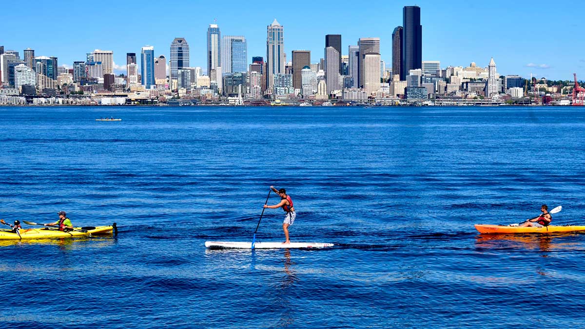
There were at least 3 drownings today at Angel Lake, Lake Washington, and in a private swimming pool on Vashon Island. People are reminded to wear a life jacket if using any kind of watercraft, swim within your abilities, and never swim alone.
About Tuesday – if you’re looking at 93 degrees and going, “sweet relief finally,” we have some bad news. The heat on Tuesday is going to be accompanied by an offshore flow, as cooler Pacific Air finally pushes back into the coast. It may reach 93, but the humidity has the potential to be higher than Saturday.
Past Tuesday the best we can hope for is around 85, which is about 10 degrees above normal. Next weekend could see us back over 90.
Sunday, June 27, 2021, 6:05 PM: The all-time record high set on July 29, 2009, of 103 degrees has been broken. SeaTac Airport reached 104 degrees for a short period of time and has been over 100 degrees for almost 5 hours. The Temperature-Humidity-Index (THI) is making it feel like 107 degrees. Our weather station in south Juanita is reporting 106 degrees (105.6 if you want to get pedantic) as the high. I’ll take being 4/10 of a degree off of my prediction for Kirkland. Highs for the Kirkland-Bellevue-Woodinville area have ranged from 103 to 109.
We aren’t ready to call this “official” until the National Weather Service has so we will wait to see if they put a flag on mount 104, 103, or if a 105 sneaked in for a few minutes.
To quote Hicks in the movie Aliens, “this can’t be happening man, this can’t be happening,” the National Weather Service has extended the Excessive Heat Warning until Tuesday, June 29, until 11 PM
In good news the three children in Ocean Shores were successfully rescued after being swept a 1/4 mile out to sea into heavy surf.
In not-so-good news, power is still out for large areas of Issaquah and small parts of Sammamish in 3 separate outages. Power is supposed to be back on shortly for both communities.
We will be looking at the weather models and updating our forecast later tonight.
Sunday, June 27, 2021, 2:15 PM: For the first time in history, Seattle reached 100 degrees or higher in a row. It is 102 degrees and the dew point is an incredible 64 degrees making it feel like 105 degrees.
Sunday, June 27, 2021, 2:15 PM: The man pulled from the water at O.O. Denny did not survive.
Sunday, June 27, 2021, 1:05 PM: Ocean Shores officials are engaged in a surf rescue for 3 children, estimated to be 6 to 12 who have been swept out about a 1/4 mile from shore. The status of the parents/guardians is unknown.
Sunday, June 27, 2021, 12:45 PM: North wind has increased to 16 MPH and it is providing a little moderation of our heat. Will it keep us closer to 100-102?
Sunday, June 27, 2021, 12:25 PM: There has been a reported near drowning of a male at O.O. Denny Park in Kirkland this afternoon. A paddleboarder was pulled from the water and people started CPR. This is breaking news.
Sunday, June 27, 2021, 11:20 AM: Seattle beat the old record high of a paltry 91 degrees at 10:45 AM when KSEA reached 92 degrees. High temperature for the day is around 6 hours away.
Sunday, June 27, 2021, 9:30 AM: King County Sheriff is reporting an apparent drowning on Lake Washington yesterday after a man fell out of a boat. Officials are still searching for the victim.
Sunday, June 27, 2021, 9:15 AM: It is 85 degrees at KSEA at 9:00 AM. This is 5 degrees hotter than 24 hours ago. Seattle was under 80 degrees for about 5 hours in the early morning. The dew point is 63, so the humidity is a touch lower than yesterday.
Sunday, June 27, 2021, 8:45 AM: The list of power outages has been updated.
Sunday, June 27, 2021, 7:05 AM: The list of cooling centers has been updated.
The National Weather Service upped the official high yesterday to 102. There is a reason why we say “unofficial high” or “unofficial low” before the record is set. We’ll write about it in another blog when things aren’t so hectic.
Sunday, June 27, 2021, 5:45 AM: For the 60% to 65% who don’t have air conditioning, last night was probably extremely unpleasant. The official temperature reports out of KSEA have us in disbelief.
9:00 PM – 88
10:00 PM – 85
11:00 PM – 83
12:00 AM – 85? Yes the temperature actually went up at midnight!
1:00 AM – 85
2:00 AM – 82
3:00 AM – 73
4:00 AM – 76
5:00 AM – 77
Our low temperature was equivalent to the normal high. 73 is listed as the official minimum. We’re upping the forecasted high for today to 106 and for Monday to 113.
A new record was set today for the all-time maximum low of 73 degrees, breaking the old record by 2 degrees. Don’t worry, that record will likely last about 24 hours.
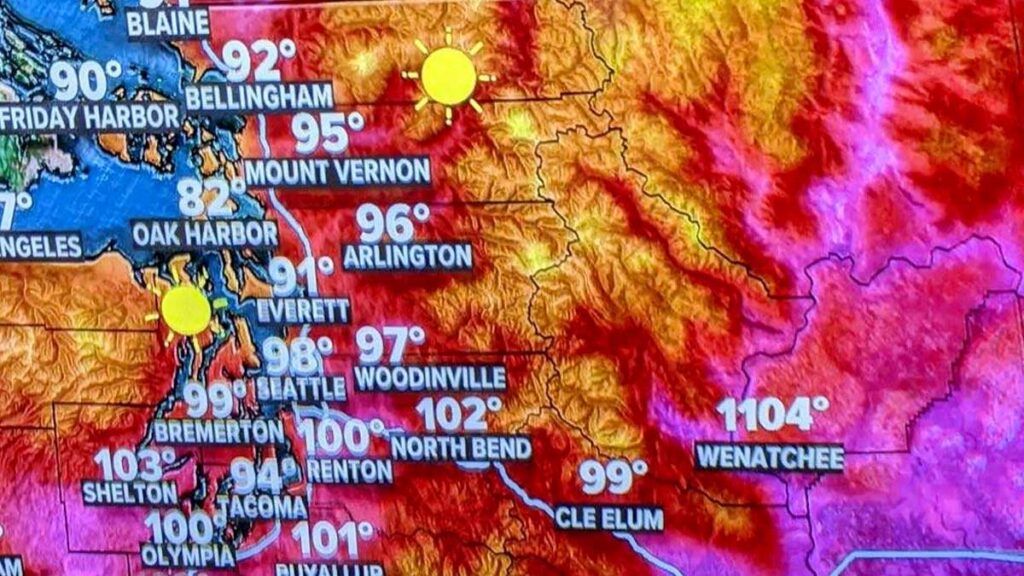
Saturday, June 26, 2021, 7:20 PM: We’re going to have a little laugh at KING 5’s expense. Apparently, Wenatchee opened the portal to Hell today by accident or someone fat-fingered the graphics. We are hoping it is the latter!
Someone made a mistake on the temperature graphic with Wenatchee reporting a balmy 1,104 degrees
Saturday, June 26, 2021, 6:40 PM: I’ve been diving into weather models. I’m pretty sure Holy $h1T isn’t an acceptable meteorological term. The GFS Ensemble forecast for Monday is – unimaginable.
GFS Ensemble Forecast for Monday, June 24, 2021, 4 PM
118 degrees at SeaTac Airport, 111 degrees downtown Seattle, and although you can’t see it 111 in Kirkland. Tacoma is also forecasted at 118 degrees. This is incredible and in a word, terrifying, as it is credible. We are not prepared to make a forecast of 113 in Kirkland and 120 at SeaTac Airport, but we will be pouring over models tonight and early tomorrow morning for Monday.
The GFS forecasted a 102 for Seattle today, and it was 1 degree off. Interestingly it is forecasting 100 degrees for tomorrow, which we think is low. Which adds to the, this can’t possibly be – possible.
Saturday, June 26, 2021, 6:10 PM: Seattle peaked out at 101 degrees today. KSEA has dropped to 100 degrees. Our weather station in south Juanita reported 102 degrees as a high (2 above our forecast). A number of locations on the eastside were reporting up to 105. This is the coolest of the 3-day run. This is what we have learned. The weather models were correct, and this wasn’t some glitch in the weather forecasting matrix. We have written how the models don’t capture the easterly flow well and tend to run conservatively. What is amazing is we had a north wind develop today and under normal conditions, it would have helped moderate temperatures. I’m running out of words in the thesaurus to describe this event. We’re holding our forecast for tomorrow of a high of 105 – and we think it will be spot on. Tonight is going to be in a word, miserable, if you don’t have air conditioning. We think the forecasted low of 70 is conservative, and we’ve bumped it up. The weather forecast, weather record, and wildfire sections have been updated.
Saturday, June 26, 2021, 4:15 PM: Multiple records were crushed this afternoon as SeaTac Airport soared to 101 degrees. It is only the fourth time Seattle has reached 100, and the earliest it has ever happened. The dew point is 62 making it feel like 103. Another hour of heating is left making it possible Seattle could tie or break the all-time high of 103.
Saturday, June 26, 2021, 3:05 PM: it is 98 degrees at KSEA and the dew point dropped to 63, it feels like 100 degrees. Two hours of heating left, 100 plus is all but certain.
Saturday, June 26, 2021, 2:05 PM: it is 96 degrees at KSEA and the dew point is still 66, it feels like 99 degrees. Three hours of heating left.
Saturday, June 26, 2021, 1:15 PM: it is 92 degrees at KSEA and the dew point is 66. THI makes it feel like 95. Four to 5 more hours of heating left today. 100 remains very likely. 89 to 97 theough our area. Remember, this is the “coolest” day.
Saturday, June 26, 2021, 12:45 PM: it is 90 degrees at KSEA and the dew point increased to 66.
Saturday, June 26, 2021, 12:15 PM: it is 88 at KSEA and the dew point is 65. This is east coast, Mid-Atlantic states in August weather. Easily another 10 degrees of heating today. The official low at KSEA hit 69. We will update our graphic.
Saturday, June 26, 2021, 10:45 AM: List of cooling centers has been updated.
Saturday, June 25, 2021, 10:00 AM: The temperature has already soared to 85 degrees at KSEA with 7 to 8 hours of warming to go. 100 degrees seems highly likely. The dew point is a stunning 64 degrees making it feel oppressive. This morning when I walked out the door it reminded me of Houston.
The high dew points are shocking.
Saturday, June 25, 2021, 6:20 AM:Road closure section updated.
Saturday, June 25, 2021, 6:15 AM: Any doubts about the computer models not getting this right disappeared early this morning. The unofficial low at KSEA was 70 degrees, one degree short of tying the all-time record for maximum low. This was 3 degrees above forecast, which means we’re already off to an early start. Last night the north wind fizzled out and a light easterly flow started. Current temperature is 72 degrees so we’ve hit the basement and going up. Expect a good 30 degrees of warming today, so 100 degrees is highly likely. Our weather station in south Juanita reported a low of 67 degrees, which was right on the money.
We have updated the forecast graphic to reflect the actuals for Friday. We are leaving the forecast through Tuesday unchanged.
Friday, June 25, 2021, 9:40 PM: OK, this is almost certainly the last entry. At 12:50 PM it was 82 degrees at SeaTac Airport. The high was 87, 1 degree above the NWS forecast. At 9:17 PM the temperature at SeaTac was 82 degrees. In the last 9 hours, the temperature has only moved 5 degrees up or down. The heat pump has started up and we enter the first day of a historic hot streak about…now. Lows tonight at SeaTac will be 66 to 68. We’re sticking with our forecast for the eastside of 67 to 69.
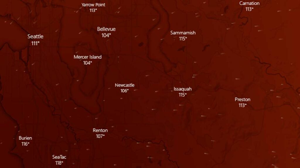
Friday, June 25, 2021, 9:30 PM: Probably the last entry for tonight. It is going to be insanely busy the next 3 days. This is the GFS Ensemble forecast for Monday, at 3 PM. Bellevue at 113, Seattle at 111 (city not airport), Renton at 116! What isn’t on this graphic is the project high temperature for Snoqualmie Pass – an unimaginable 100 degrees.
GFS Ensemble Forecasted Highs for Monday, June 28, 2021
Friday, June 25, 2021, 9:20 PM: List of cooling centers has been updated.
Friday, June 25, 2021, 7:00 PM: We are feeling confident about our forecast for Saturday and Sunday. The models are indicating Monday could reach 113, but we’re just not convinced. We’ll hold off for another 12 hours to see if we need to make an adjustment or not.
Friday, June 25, 2021, 6:15 PM: Might have typed too soon, KSEA is back up to 87 degrees and the humidity dropped a little more, could there be a stretch to 88? We’ll see.
Friday, June 25, 2021, 5:30 PM: The unofficial high temperature at KSEA is 87 degrees. Won’t become “official” from a meteorological stand point until tomorrow. That was within our forecast for today on the low end. Our weather station in south Juanita is 88 degrees.
Friday, June 25, 2021, 4:45 PM: KSEA is at 86 degrees, our weather station in south Juanita is reporting 87 degrees. A north wind at 9 MPH is holding temperatures down slightly at SeaTac. The heat of the day will come in the next hour.
Friday, June 25, 2021, 2:40 PM: Have a flight out of SeaTac Airport between now and Tuesday? You might want to be prepared for delays, especially Sunday and Monday. Hot air reduces the amount of lift an airplane can create because the air is “thinner.” This requires longer takeoff rolls and landing at higher speeds, both can slow down airport operations.
Friday, June 25, 2021: 2:15 PM: Model runs indicate the forecasted highs for Sunday and Monday, along with the forecasted low for Sunday night are likely conservative. As we get closer to these dates the confidence in the forecast models gets higher. We may adjust our forecast later tonight to add a couple of degrees to the highs and lows on Saturday, Sunday, and Monday.
Friday, June 25, 2021, 1:45 PM: SeaTac Airport (KSEA) is up to 82 degrees with the clouds mostly burned off. Still about 4 hours of warming to go. Wouldn’t bet against KSEA hitting 90 degrees.
Friday, June 25, 2021, 12:30 PM: Governor Jay Inslee has announced he is lifting COVID-related capacity restrictions at publicly-owned cooling centers due to the weather emergency, effective immediately. Facilities such as government buildings and libraries can operate at full capacity. Capacity restrictions still apply to privately owned for-profit facilities such as malls and movie theaters.
Friday, June 25, 2021, 9:00 AM: The forecast models are leaving mouths agape in the weather community as a ridge of high pressure starts to build. A weak marine layer has been pushed out and we are entering the first day of this historical weather event. It is likely many weather records will be broken over the next 4 to 5 days.
We are off to a warm start with area temperatures in the mid-60s. Seattle-Tacoma Airport (KSEA) low temperature was a balmy 67 degrees in part because of a marine layer that tried to push in last night. The temperature as of this writing is 69 under partly cloudy skies, but on the eastside, those clouds have already burned off.
Forecast models continue to get hotter, especially for Monday. Either every weather computer model is completely wrong and has failed to forecast this scenario, or we are going to make history.
Most Up-To-Date Weather Forecast
Last Updated: Tuesday, June 29, 2021, 10:15 PM
The National Weather Service has EXTENDED the EXCESSIVE HEAT WARNING in effect from 2 PM Friday to 11 PM Tuesday. Impacted areas include Western Whatcom County-Southwest Interior-Western Kagit County-Everett and Vicinity-Tacoma Area-East Puget Sound Lowlands-Bellevue and Vicinity– Seattle and Vicinity-Cascades of Whatcom and Skagit Counties-Cascades of Snohomish and King Counties-Cascades of Pierce and Lewis Counties-Including the cities of Bellingham, Olympia, Lacey, Tumwater, Mount Vernon, Anacortes-Sedro-Woolley, Burlington, Everett, Edmonds, Lynnwood, Marysville, Tacoma, Covington-Sawyer-w, Maple Valley, Monroe, Prairie Ridge, Enumclaw, Bonney Lake, Woodinville, Redmond, Kirkland, Bothell, Kenmore, Newport Hills, Sahalee, Pine Lake, Seattle, Concrete, Lyman, Hamilton, Darrington, and Morton
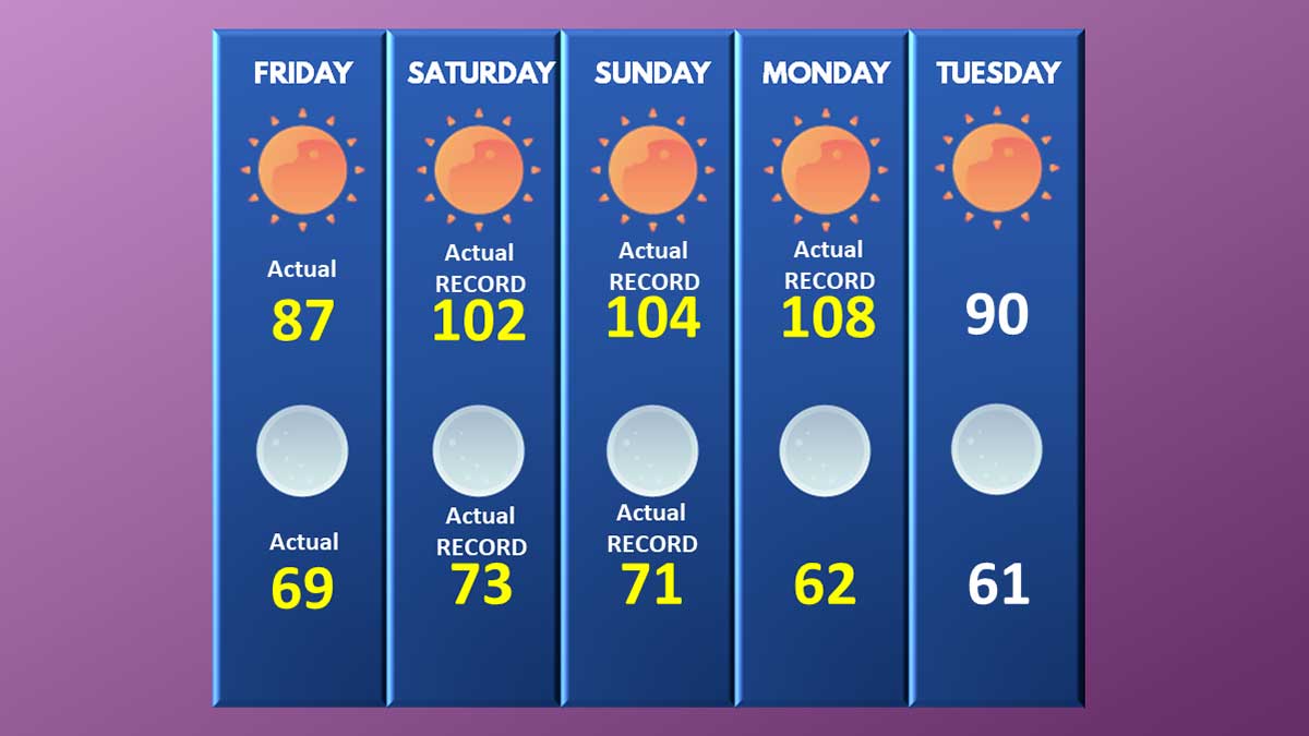
Friday: Today will be considered hot by Puget Sound standards. High temperatures will be 87 to 92 degrees, but this is only the beginning. Kirkland-Bellevue-Woodinville target – 90 degrees.
Actual: KSEA 87 degrees, Kirkland at our south Juanita weather station, 90 degrees
Friday Night: High pressure builds along with a light easterly flow off the Cascades. Lows will be 65 to 69. Kirkland-Bellevue-Woodinville target – 67 degrees.
Actual: KSEA 69 degrees. Kirkland at our south Juanita weather station, 67 degrees
Saturday: Record-breaking heat will blanket the region. High temperatures will soar to 98 to 102 under sunny skies with variable winds. Kirkland-Bellevue-Woodinville target – 100 degrees.
Actual: KSEA 102 degrees. Kirkland at our south Juanita weather station, 102 degrees
Saturday Night Potentially record-breaking with near historically high minimum temperatures. Lows from 70 to 73 under clear skies. Kirkland-Bellevue-Woodinville target – 72 degrees.
Actual: KSEA 73 degrees. Kirkland at our south Juanita weather station, 71 degrees
Sunday: Historically hot. High temperatures will reach a dangerous level for our region with highs of 104 – 108 under sunny skies. Kirkland-Bellevue-Woodinville target – 106 degrees.
Actual: KSEA 104 degrees. Kirkland at our south Juanita weather station, 106 degrees
Sunday Night: Historically hot with low temperatures higher than the normal daytime high, providing little to no relief from the daytime heat. Area lows of 74 to 77 degrees will set all-time records for the highest minimum temperature in regional history. Kirkland-Bellevue-Woodinville target – 76 degrees.
Actual: KSEA 71 degrees. Kirkland at our south Juanita weather station, 73 degrees
Monday: Unprecedently heat. High temperatures will soar to 111 to 116 degrees under sunny skies as the ridge of high pressure moves east and parks the thermal trough right over the I-5 corridor. Kirkland-Bellevue-Woodinville target – 114 degrees.
Actual: KSEA 108 degrees. Kirkland at our south Juanita weather station, 71 degrees
Monday Night: The ridge of high pressure will start to lose its grip on our area and marine air will push in along the coastline. Low temperatures will be 67 to 71, which is still be near normal daytime highs. Kirkland-Bellevue-Woodinville target – 69 degrees.
Actual: KSEA 62 degrees. Kirkland at our south Juanita weather station, 65 degrees
Tuesday: Temperatures moderate but will still be close to 20 degrees above normal. High temperatures will be 89 to 93 under clear skies. Kirkland-Bellevue-Woodinville target – 90 degrees.
Actual: KSEA 84 degrees. Kirkland at our south Juanita weather station, 87 degrees
Tuesday Night: Marine air pushes further inland, with low temperatures of 59 to 63. Kirkland-Bellevue-Woodinville target – 61 degrees.
Weather Records we are Watching
Last Updated: Tuesday, June 29, 2021, 10:10 PM
June 26 record high: 93 degrees – Federal Building – BROKEN – new record 102 degrees KSEA
June 27 record high: 91 degrees – BROKEN – new record of at least 104 degrees KSEA
June 28 record high: 91 degrees – BROKEN – KSEA reached 108 degrees
June 29 record high: 93 degrees – high 84 degrees
June all-time high: 96 degrees KSEA, 98 degrees Federal Building – KSEA BROKEN, FEDERAL BUILDING BROKEN – 102 degrees KSEA June 26
BROKEN, 104 degrees KSEA June 27
BROKEN, 108 degrees KSEA June 28
Seattle all-time high: 103 degrees, July 29, 2009 – BROKEN, UNOFFICIALLY ON MONDAY – 108 DEGREES June 28. This breaks the previous record set on June 27, 2021
Number of times Seattle has reached 100 degrees: 3, 1 at Federal Building, 2 at KSEA – June 26, 4th time and earliest to 100 degrees in Seattle history
June 27, 5th time in history
June 28, 6th time in history
Number of days in a row over 90 in June: 3 TIED – Streak ends at3
Number of days in a row over 90, any month: 5 Streak ends at3
Number of days in a row over 80, any month: 15 Streak is at 6
Number of days in a row over 100 degrees: 1 – Seattle has never had a multi-day streak at or over 100 degrees Streak ends at 3
Seattle all-time maximum low: 71 degrees – KSEA BROKEN, 73 DEGREES, June 27
Earliest to 90 degrees: June 28, 2021, before 8:00 AM
Earliest to 100 degrees: June 28, 2021, before 12:00 PM
Longest amount of time over 100 degrees: June 28, 2021, 8 hours
Brush and Wildfire Reports
Last Updated: Monday, June 28, 2021, 7:35 PM
The Cedar Hills Fire grew from 1 acre to 30 acres in about 6 acres and is located in between Renton, Issaquah, and Maple Valley near the Maple Hills Elementary School. State resources have been authorized to fight the blaze and a helicopter has started water drops. Fire fighters have created a defensive line to protect homes and power transmission lines.
Crews are battling the Lind Fire, close to the town of Lind, Washington, which has burned about 20,000 acres. The fire exploded from 425 acres to 20,000 acres. Level 1, 2, and 3 (evacuate now) orders have been issued.
The National Weather Service discussion on Sunday afternoon indicated that the Cascades of eastern King, Pierce, and Lewis County will receive a Red Flag Warning on Monday. The Haines Index is a value that indicates the probability a large wildfire could erupt. Parts of the South Sound are at a 6, which is as high as the Haines Index goes. People pulling trailers need to make sure safety chains aren’t dragging, and smokers should not throw cigarette butts out. Brush fires along our highways can start very easily now.
S-503 Fire – Warm Springs Reservation – 7 miles northeast of Simnasho, Oregon: The fire is 60% contained and has burned 6,679 acres. The number of acres involved is unchanged.
Power Outages
Last Updated: Sunday, June 28, 2021, 10:35 PM
June 28, 2021, 10:35 PM: About 4500 customers in the North Beach/Greenwood area of Seattle are without power. Electricity is not expected to be restored until 2 PM on Tuesday, marking this the longest and one of the largest area outages of the heatwave. Power has been restored by Puget Sound Energy near Eatonville and Graham.
June 28, 2021, 7:30 PM: Approximately 2,900 customers have lost power near Eatonville and Graham. PSE has no ETA for restoring power at this time. Power has been restored in Auburn and Lake Tapps.
June 28, 2021, 4:30 PM: Auburn and Lake Tapps are experiencing a significant power outage according to Puget Sound Energy, with large areas east of SH-169 without power since 2:30 this afternoon.
June 28, 2021, 8:45 AM: There are over 80 spot outages according to Puget Sound Energy with about 2,100 customers impacted. Power was restored in Kirkland overnight (the largest outage last night). Expect to see numerous spot outages throughout the day.
June 27, 2021, 10:25 PM: 3,127 customers in Kirkland have been plunged into the dark with no AC, fans, or way to cool off. The outages have been caused by multiple small failures and are not due to a lack of capacity to meet electrical needs. PSE does not have an ETA for power restoration.
June 27, 2021, 3:00 PM: Over 120 spot outages have been reported across the entire region between Puget Sound Energy and Seattle Power. The peak number of impacted households was about 12,000, with the largest outage in Issaquah.
June 27, 2021, 3:00 PM: Significant power outage in Issaquah impacting 12,000 customers.
June 27, 2021, 9:30 AM: 3,000 customers without power in Graham due to a car accident.
June 27, 2021, 9:30 AM: Power restored at North Rose Hill.
June 27, 2021, 8:45 AM: There are multiple power outages scattered across the PSE service area. All are small, some just a single address. The largest is the North Rose Hill area of Kirkland and Redmond impacting about 300 customers.
Road Closures and Emergency Repairs
Last Updated: Sunday, June 28, 2021, 4:45 PM
Two lanes are closed on I-5 North at milepost 132 in Tacoma (near the I-705 interchange) due to heat related damage to the road surface. A temporary repair did not hold and the road started to shed chunks of concrete. Repair work cannot start until temperatures drop lower. Avoid the area or bring patience.
Multiple lanes are closed on southbound I-5 at 130th in North Seattle due to the road surface buckling from the heat. No ETA on when repairs will be made. Additional road panels buckled at 145th shortly after the failure at 130th.
State Highway 21 near the town of Lind has been closed due to a 20,000 acre wildfire.
Southbound I-5 from the I-90 off-ramp to Spokane Street is closed (this is by the West Seattle Bridge). This was part of a planned Washington DOT project that is moving forward this weekend. Drivers are being asked to avoid the area and this section of I-5 as possible as significant delays are expected. The closure is through June 28, 2021.
Highway 30 in Oregon close to the Washington border is closed from Simonelli Road to Rowena due to a wildfire outside of The Dalles, near I-84 milepost 76 to 80. Three separate wildfires erupted on Friday, June 25, 2021, and are currently contained but still burning.
[KIRKLAND] – (MTN) The record isn’t officially in, but SeaTac Airport got to at least 106 degrees with an unexpected west wind helping keep things cooler than forecasted. Less than 20 miles to the northeast, Bellevue and Kirkland appear to be the regional hot spots with temperatures from 108 to 114 throughout the area. So the question of the afternoon is, is it hot enough to bake cookies on the dashboard of a car?
You may have seen the videos of people putting prepared cookie dough a foil lined cookie sheet in a car during the heat of the day, and eating baked or semi-baked cookies a couple of hours later. We’re putting it to the test.
We bought an 88 cent Kroger brand 12-pack of break and bake cookie dough and put it on a foil-lined pan in our company truck. The truck has been parked all day, and the dashboard is facing due west with direct sun. The temperature according to our weather station is 111 degrees and a thermometer we put inside the truck had gone past the 120-degree mark and was pointing at the -60, so roughly 155-160 degrees inside.
We put the cookies in at 4:01 PM and we’ll see if we can have milk and cookie time at 6:00 PM. Do you think they’ll be ready?
[KIRKLAND] – (MTN) Meteorologists around the world have their eyes on the Pacific Northwest as an unprecedented and historic heatwave will send temperatures to dangerous levels never seen in the Seattle area. A strong upper-level ridge, an area of high pressure, is building off the coast of Washington and will park over British Columbia this weekend. Forecasting models have been consistent for almost a week, and what was disbelief a few days ago has turned into shock.
Hot will it get? Seattle will be hotter than Miami, Houston or Jerusalem, and forecasted temperatures will rival Yuma, Arizona and Cairo, Egypt.
During a typical heatwave, like the one the region experienced in July 2009, an area of high pressure forms over the four corners region of the United States and drifts northwest off our coast. These systems create an onshore flow, pulling dry warm air from eastern Washington into the Puget Sound lowlands and blocking the cool marine air of the Pacific Ocean.
East winds send air down the Cascades causing the air to compress. The compression squeezes out the moisture and warms the air, giving us our 90 plus degree days in the lowlands, and sometimes very strong winds in the foothills in towns like North Bend and Issaquah. For our coming heatwave the location of the ridge, how fast it is building, and how intense it is, has never occurred.
Normal highs for June are the high 60s to low 70s, so even our “cool” day on Wednesday with a high of 77 was above normal. Thursday will be pleasant before the blowtorch is pointed at the region.
Thursday: The marine layer and low clouds that came in this morning didn’t push as far inland as yesterday. Today will be sunny with some possible high clouds north of the Kirkland-Bellevue-Woodinville area. Temperatures will be 79 to 83 degrees.
Thursday Night: A marine layer will try to push in from the coast one last time, but it won’t make it to our area. It will be partly cloudy before dawn, with temperatures from 59 to 63.
Friday: The onshore flow will start and intensify through the day. Friday will be similar to Monday this week with sunny skies and temperatures from 87 to 91 degrees. Winds will be light.
Friday Night: With high pressure building to our north, hot air from the desert southwest will flood into our region. Friday night lows will be 64 to 68 degrees under clear skies.
Saturday: Hot air will entrench into the region, sending temperatures soaring. The further away from the water and south you go the hotter it will get. Highs on Saturday will be 97 to 101 in the Kirkland-Bellevue-Woodinville area. It may be slightly cooler right on the shore of Lake Washington. Our hot spots like downtown Bellevue, Totem Lake, and Kingsgate will see the highest temperatures. Saturday’s record high is 93 degrees set at the Federal Building (91 at SeaTac Airport), and both records will be smashed. The all-time record high for June is 98 degrees, and that record is at risk. If it doesn’t get broken on Saturday, it will get destroyed on Sunday.
Saturday Night: The ridge of high pressure will continue to intensify, providing little relief from the heat. Low temperatures will be record-setting, dropping only to 69 to 73 degrees under clear skies.
Sunday: It will be historically and dangerously hot. High temperatures will soar to 102 to 106 degrees through our area under sunny skies. The record high for Seattle is 91, and it will be obliterated. The all-time record high for Seattle is 103 degrees, set on July 29, 2009. That record is at risk of being broken.
Sunday Night: Historically hot with the highest low temperatures in Seattle history. Lows will be 72 to 76 degrees under clear skies with no wind. The heatwave is happening during our longest days of the year, with less than 8 hours between sunset and sunrise, offering little respite from the heat.
Monday: Unprecedently hot with historic and dangerous temperatures. Highs will soar to 103 to 107 degrees under cloudless skies and light winds. The record high for Seattle is 91 degrees and will be shattered.
Monday Night: The ridge of high pressure will finally start to move eastward, allowing cooler air from the coastline to moderate our temperatures. Temperatures will be 65 to 69 degrees under mostly clear skies.
Tuesday: Temperatures will still be 20 to 25 degrees above normal. Highs temperatures will reach 91 to 95 degrees. The record high for Seattle is 93 degrees and will be at risk of being broken.
Typically after heatwaves, our region gets a big push of marine air and returns to near normal temperatures with a cool gray morning. The long-range forecast as far out as we can see shows a very light offshore flow will return, but will not bring a big push of marine air. Temperatures will remain 10 to 15 degrees above normal according to long range models.
Burn bans instated throughout Washington as fire danger soars
The King County Fire Marshall has issued a stage 1 fire safety burn ban effective Thursday until further notice for unincorporated areas of King County. For the Kirkland-Bellevue-Woodinville area, sections of Woodinville are impacted. The ban applies to “all outdoor burning, except for barbecues and small recreational fires in established fire pits at approved campgrounds or private property with the owner’s permission.” An approved fire bit is 25 feet from all structures, 20 feet away from overhanging branches, has no vegetation within 10 feet, is no more than 36″ across, and is made of concrete or metal. The fire must be attended at all times and must be fully extinguished.
The Washington State Department of Natural Resources has also issued multiple burn bans throughout Washington state.
King, Pierce, Kitsap, and Mason counties are under a level 4 burn ban until further notice due to moderate fire danger. Industrial fires are banned, and only recreational fires are allowed and must be attended.
Grays Harbor, Jefferson, and Clallam counties are under a level 2 burn ban until further notice due to moderate fire danger. Rule and permit fires are banned, industrial or debris fires are not allowed, and campfires are allowed only in designated campgrounds on DNR land.
Lewis, Cowlitz, Clark, and Pacific counties are under a level 4 burn ban due to moderate fire danger starting Friday, June 25, until further notice. industrial or debris fires are not allowed, and campfires are allowed only in designated campgrounds on DNR land.
Chelan and Wenatchee counties are under a level 4 burn ban due to high fire danger. Rule and permit fires are banned, industrial or debris fires are not allowed, and campfires are allowed only in designated campgrounds on DNR land.
Power grid in Western Washington should hold, Oregon officials fret
Area officials aren’t concerned about the power grid and its ability to keep up with demand. Seattle is the least air-conditioned city in the continental United States, with only 33.7% of Seattle homes equipped with central air or a room AC unit, compared to 89% of the United States. Many office buildings and commercial spaces remain empty due to COVID restrictions.
Oregon officials are more concerned particularly in the Portland area where 70% of homes now have air conditioning. PGE in Oregon has stated they are ready for the surge in demand and do not anticipate a need to do rolling blackouts in northern Oregon. Temperatures could reach over 110 degrees Saturday to Monday in Portland.
Update: The National Weather Service has issued an Excessive Heat Watch from Friday afternoon through Monday afternoon for temperatures approaching 100 degrees.
[KIRKLAND] – (MTN) Seattle tied the record high on Monday, with SeaTac Airport recording a high of 89 degrees, but if the forecast models hold, 89 may seem like sweater weather compared to what lies ahead. Puget Sound could see a historic heatwave this weekend and into early next week.
A powerful ridge of high pressure is expected to develop and push into our area on Friday, allowing a tongue of brutally hot air from the desert southwest to flow into our region. How hot? Some computer models are forecasting temperatures as high as 110 degrees for Seattle on Monday! Relax, those models are outliers, but the use of the word “historic” to describe what could be coming isn’t hyperbole.
The Pacific Northwest is notoriously tricky to forecast because a weather system moving 50 or 100 miles off the predicted path can dramatically impact accuracy. The location of the ridge, how effective it is on blocking any offshore flow, and the strength of the ridge has forecast models indicating a 25 degree spread for this weekend. It is like looking at snowstorm weather models forecasting 2″ of snow to 14″ of snow and trying to decide which one is right.
Stop stalling, or I’ll stop reading!
So far, this is what I think we are looking at, but my confidence isn’t high enough to say, “this is the forecast.”
The ridge will arrive on Friday, and the marine layer that pushed in a little bit today, and will push in hard tomorrow, will be on its way out. Friday looks like a near copy of Monday, with highs from 86 to 90 in the Kirkland-Bellevue-Woodinville area.
Friday night won’t offer much relief, and temperatures will be from 62 to 65 under clear and windless skies. Saturday is when the furnace kicks in.
Saturday could be historically hot. Temperatures in the Kirkland-Bellevue-Woodinville area will be 97 to 101 under clear skies and almost no wind. The record high for Saturday is 93, and I feel confident enough to say this record is at risk. If SeaTac Airport reaches 100 degrees on Saturday, it will be the fourth time in history Seattle has officially reached 100 degrees. Some forecast models are putting the dewpoint in the high 50s, which isn’t southeastern United States sticky, but it will be enough to notice this isn’t exactly our typical dry heat.
Saturday night has the potential to be historically hot. Forecast models are indicating almost no breeze to look forward to and an onshore flow. The only saving grace is it will be clear a night, allowing some of the heat to radiate to space. Lows will be 67 to 71.
Sunday is looking even hotter. The ridge will further entrench offshore, pumping the historically hot air into our region. Highs on Sunday could be 98 to 102. The record high on June 27 is 91 degrees and even if the forecast moderates, that record will almost certainly be broken. Some models show the dew point reaching 60 degrees. Last year during our hottest days we had desert humidity as low as 14%. Dew points will be about 15 degrees higher. It won’t’ feel like Georgia, but it won’t feel like eastern Washington either.
Sunday night looks like a copy of Saturday night. A relentless onshore flow, near windless and clear. Lows will be 67 to 71.
Monday is too far out to predict with confidence, but the models indicate it could be as hot or even hotter than Sunday. If the ridge aligns in the right spot and parks for long enough, there is a real possibility of three 100 degree days in a row for our area with dewpoints near 60, which would be unprecedented.
The ridge looks to move eastward on Tuesday and the onshore flow finally breaks up. Real relief won’t come until Wednesday, June 30. Writing a forecast more than 4 or 5 days out is throwing darts, but if I had to make a prediction, Tuesday could reach 90.
If you think this all sounds horrible, it could be worse. Portland, Oregon could reach 100 on Friday and 110 on Saturday, Sunday, and Monday. Spokane is looking at a 6-day streak over 100 degrees as a possibility, with highs reaching up to 110 by Monday.
The all-time record high in June is 98 degrees. Historically, Seattle has never seen three 100 degree days in a row, and in my 21 years here, I have never seen a forecast model so supportive of this kind of heatwave. The all-time record high for Seattle is 103, reached on July 29, 2020. That record appears safe, but that will be cold comfort for many.
Last year, forecast models supported several days but not in a row, possibly reaching 100 degrees or higher, but dense forest fire smoke moderated our highs by 4 to 8 degrees keeping us in the mid-90s on the worst days. There is no smoke in the forecast, but the risk of brushfires and wildfires even in the lowlands will dramatically increase as we approach the Fourth of July, even if these high temperatures moderate into the 90s as we get closer to the weekend and our confidence grows in the forecast.
[KIRKLAND] – (MTN) The weather forecast crystal ball can’t see to June 30 yet, but there is a chance that our region could see a 10-day streak of 80 plus degree days with no rain. SeaTac Airport is up to 78 degrees for the first day of summer and the longest day of the year and will likely hit 80 degrees with ease today.
It is far too early to say that a 10-day streak with highs over 80 degrees is a lock, but it appears possible. Wednesday is the one day where 80 might be a tough reach, but the marine air push that models indicated we would get on Tuesday night continues to weaken with each new set of forecast runs. The chance for some spits of drizzle in the early morning hours on Wednesday has metaphorically evaporated.
For Kirkland-Bellevue-Woodinville high temperatures will be 80 to 84 today, and most of our readers are already over 80 degrees.
Monday will see record-breaking heat, with highs of 87 to 91 through our area. The record high at SeaTac Airport is 89 degrees and could fall.
Tuesday will see highs of 78 to 82, and Wednesday 77 to 81. After that, the crystal ball gets a bit hazier, but computer models indicate next Saturday could see temperatures of 90 to 94 degrees. Looking out to June 29, there is no rain in the forecast models, and the only day with a real chance of not reaching 80 is Wednesday.
One trend over the last 20 years has been increasingly warmer nighttime temperatures throughout our region. Forecast models for the end of the coming week indicate lows will be in the 60s, which won’t provide much relief in the overnight hours.
For long-term Seattleites, if you’re thinking that “Juneuary” is starting to disappear and the adage “summer starts on July 5th” is fading away, you would be correct. The last time it rained on the Fourth of July at SeaTac Airport was 2010. The last time Independence Day didn’t get over 70 degrees was in 2016.
If your home doesn’t have air conditioning, you can strategize to beat the heat. Open your windows at night to let the cool air in, and then in the morning, close your windows and blinds to trap that cooler air. If you have a multistory home, you can run a fan to circulate the cooler air from the first floor through the house. In the late afternoon or early evening, when the inside of your house is warmer than the outside temperatures, opening the windows again allows the cool air to flow back in.
This is also a good time to buy fans if you don’t have one, because they will be harder to find in the days to come. Finally, if you haven’t prepared for smoke season, this is the time to buy a heater filter to strap to your box fan and prepare your cleanroom.
[KIRKLAND] – (MTN) If you’re thinking June has been a wild ride so far with record heat, the coldest day in 9 years, and almost a month of rain in a single day, you would be correct. So far, June 2021 has been provided all of the above and we’re headed back to the furnace with potential record heat ahead.
Currently, the desert southwest is baking in historical heat. Phoenix Arizona reached 116 degrees, Palm Springs, California tied its all-time record high of 123, and Furnace Creek, California reached 128 on Thursday as electrical grids strained to keep up with demand. That area of high pressure is going to drift west and carry with it hot air into Puget Sound. By Sunday our region will be in a classic offshore flow pattern which pumps dry, warm air into the lowlands.
For today, the Kirkland-Bellevue-Woodinville area will be seasonably warm with highs from 71-74 under blue skies. Evening temperatures will drop to 50-54 degrees during the overnight with another glorious day as we get ready to end spring.
Saturday will see highs reaching 73-77 under partly cloudy skies. The evening will be noticeably warmer with lows from 53-56 – perfect sleeping weather.
Sunday will see winds increase to 10 to 15 MPH as that area of high pressure drifts further to the west, and temperatures move into the 80s for the entire area. When the winds die down on Sunday, the heat pump and onshore flow will be on and highs will reach 82 to 86. Lows will be 57 to 60, while humidity will continue to drop.
Monday is the day we’re going to cook and has the potential to break weather records. The computer models we’re looking at indicate temperatures in our area will be 85 to 89, but we have found that many weather models don’t account for the offshore flow enough. Highs at SeaTac Airport, where it matters for the record books, will be 87 to 91. Highs in the Kirkland-Bellevue-Woodinville area will be 88 to 92. The record high at SeaTac Airport for Monday is 89, and that is definitely at risk. A toasty day on what will be the longest day of the year and the first day of summer.
Monday night as the potential to set a record warm “low” temperature. The warmest low at SeaTac Airport is 61, and we wouldn’t bet against that record getting broken. Low temperatures for our area will be 59 to 62.
There is almost no chance of rain in the forecast for as far out as we can see. The eastern flow will continue on Tuesday but the marine air will start to push back in, moderating temperatures. Wednesday looks to be mostly cloudy as the marine air rushes back in to the lowlands. It wouldn’t be unreasonable to say some pockets of very light mist or drizzle are possible on Wednesday in the early morning hours.
Despite the heat that is coming this weekend and early next week, area lakes and rivers, along with Puget Sound continue to be cold. Snowpack was almost historically high and the warm temperatures will increase mountain runoff, making our area rivers cold and fast. Even on a 90 degree day, hypothermia is possible. If you’re planning to visit our area rivers, canoe, kayak, or innertube in safe areas, or at your skill level and wear a flotation device.
[SEATTLE] – (MTN) The forecast called for a soggy and humid Sunday and that is exactly what the Puget Sound region is getting today. Rain from the current system moved in around 10 PM last night dropping 1/3 of an inch on the dot from the start of Sunday to about 10 AM. The middle of the day had a few drips before the rain returned around 3 PM. Another half-inch has fallen with more on the way, putting the unofficial total at 0.85 inches.
The weather record for June 13 at SeaTac Airport is 1.03 inches, interestingly set in 2020. The wettest June day ever was June 3, 1905 at the Federal Building downtown when 1.42 inches of rain fell. The wettest day at SeaTac was June 7, 1985, when 1.33 inches of rain fell.
Unofficially, June 2021 is at 2.17 inches, well above the monthly average of 1.57 inches, and creeping closer to top ten territory. Despite the wet start to meteorological summer, the region is still running a serious rainfall deficit.
Temperatures were cooler than the forecast models indicating, only getting to an unofficial high of 64. the humidity was delivered as forecasted, with dew points in the 60s in most of the area.
The weather is considered a contributing factor to a 13-car accident on I-5 at 1:15 AM in downtown Seattle. The initial accident caused a 3-car pile-up in the backup which resulted in the death of an off-duty Seattle police officer who exited his vehicle to render assistance.
[KIRKLAND] – (MTN) The Seattle area had the fourth driest spring in history, and it appears that the region will make up some of that precipitation deficit this weekend. An unusual weather pattern will bring a Pineapple Express to the Pacific Northwest on Sunday. Sunday will feel more like a rainy March day in Orlando versus our usual June gloom.
Two rare events are coming together to turn Seattle from Fifty Shades of Grey to Sixty Shades of Sticky. Pineapple Express weather systems are more associated with wintertime storms carrying tropical moisture on a conveyor belt straight to the Pacific Northwest. These systems bring heavy rains, breezy conditions, and warmer temperatures.
Sunday’s weather models shows a river of moisture extending from Hawaii to the Pacific Northwest
Usually, when we warm up in Seattle, it is from an eastern flow from the Cascades. The air compresses and gets warmer, squeezing out the moisture at the same time. Our hottest days typically have low humidity, so we get a “dry heat” in the lowlands to make it feel more tolerable. These same easterly flows dry out our air, preventing rain from falling.
In more recent years, we have gotten hot days from warm air coming from the southwestern United States, which is happening this weekend.
In reviewing the weather models, there is agreement on when and where but disagreement on how much rain. There is widespread agreement that southwest Washington and the Olympics will get significant rain on Sunday morning and the Cascades later in the day as the system makes landfall. One model predicts widespread record rainfall for Seattle, with the potential for one inch of rain – average rainfall for June is 1.57 inches!
For the rest of Friday, our area will see a typical Juneuary day of clouds, rain showers, and sun breaks. High temperatures will struggle to reach 58 to 62 in the Kirkland-Bellevue-Woodinville area. The wettest period will be between 2 PM and 4 PM.
Friday night could bring some more light showers into the area, with lows from 52 to 54 degrees.
Saturday is looking pleasant, although partly to mostly cloudy. Highs will be 73 to 78, depending on what time the cloud cover starts to thicken up for the main event. It won’t feel sticky, but you may think to yourself, “this feels warmer than the 70s.”
Saturday night and early Sunday morning, the Pineapple Express arrives. Models are predicting rain will increase from 3 AM to 5 AM. Low temperatures will only drop to around 60 degrees, and dew points will creep into to 60s.
Sunday will see variable amounts of rain. Heavy rain showers will form with a chance for some grumbles of thunder. In the heaviest pockets, there could be minor street flooding and reduced visibility. Temperatures will hover around 70 degrees, while the dew point could reach 67. Your friends and family on the east coast won’t offer any sympathy if you call and complain about it being muggy, but this is a rare event for Puget Sound.
How much rain you will get on Sunday will depend on your location, and weather records will fall if a heavy pocket of rain lingers over the rain gauge at Seattle-Tacoma International Airport. Some areas may see 1/3 to 1/2 an inch of rain, while localized areas could see an inch or more.
Looking further out, Monday will get a little drier, but the humidity will linger. Tuesday appears to bring a round of spotty showers and thunderstorms to the area before moving back to a dry summertime pattern.
Journalists, activists, and researchers defending the First Amendment
Subscribe to Malcontent News
Register to feed your head holes with the Malcontent News newsletter.
Submitting your e-mail address gives us permission to send you e-mails. We do not sell or distribute our e-mail lists or share them with third parties.