[KIRKLAND, Wash.] – (MTN) After a rollercoaster summer of record-shattering heat, a tie for the driest July since weather records have been kept, and 51 days without rain, fall is arriving. A particularly strong storm system for mid-September is delivering three days of rain, the potential for urban flooding, and strong winds on Friday afternoon.
The central pressure of the storm approaching is flirting with 990 MB, which is similar to Hurricane Nicholas that hit Texas on September 14. For the Kirkland-Bellevue-Woodinville area, the two issues will be rain through the weekend and wind this afternoon.
It’s already raining across the region, and rain will fall through the day, with the chance for heavy showers and even a growl of thunder. Over lunchtime, there could be a break in the rain, but don’t be fooled. Between 3 to 5 PM will the rain will pick up, get heavier, and the winds will increase. Peak winds will be between 7 PM and 10 PM at 15 to 20 MPH, with gusts up to 40 MPH.
The heatwave in June followed by very little rain has stressed many trees that are still full of leaves. Between the heat stress and the foliage that can act like sails, the usual trouble spots such as Finn Hill should expect to lose power. There isn’t enough wind in the forecast model in Central Puget Sound for a Wind Advisory, but areas north of Everett could see gusts over 50 MPH.
Temperatures will be in the low to mid-60s. Over the next 24 hours, close to an inch of rain should be expected for the area.
Rain will taper off briefly on Saturday morning, while the wind will continue into the afternoon. Another shot of rain will arrive around noon, and you should expect rain through Sunday. On Saturday another 1/3 of an inch is expected, with another 1/3 on Sunday. If the forecast model holds, our region will get a month of rain in 3 days, in what will feel like a repeat of our major rain event back on June 13-14.
Temperatures will hold in the mid-60s during the day and the mid-50s during the night.
Rain could get heavy enough to cause some minor urban flooding in locations such as 120th in Kirkland in front of Fred Meyer.
[KIRKLAND, Wash.] – (MTN) The Seattle area is poised to break 100 degrees for the fourth time this summer, with a significant heatwave forecasted for the rest of the week. The National Weather Service issued an Excessive Heat Warning, including the Puget Sound Lowlands, from noon on Wednesday to 7 PM on Saturday.
A ridge of high pressure is building over the Pacific Ocean, bringing eyebrow-raising heat to our region, but not as hot as the record-shattering heatwave in June. Temperatures broke 100 degrees three days in a row earlier this year during a historic heatwave that shattered all-time temperature records from Alaska to California.
In addition to the heat, Western Washington can expect some smoke to move into the region. High-pressure areas circulate counter-clockwise, which will pull smoke up from Southern Oregon and Northern California. Thursday and Friday are looking to be the worst days, but they won’t be like last year’s conditions. Most of it will be aloft, but some near-surface smoke is supported in the models. One other plot twist, the smoke is making Friday’s forecast pretty challenging.
Wednesday will start with partly cloudy skies and a low around 60 degrees F. in the Kirkland-Bellevue-Woodinville area. Temperatures will reach 87 to 90 degrees F. The usual hot spots of Totem Lake, Kingsgate, and the urban canyons of downtown Bellevue will likely get to the 90 degrees F. mark.
Wednesday night temperatures will drop to 62 to 64 degrees F. in our area. We’ll get a bit of offshore flow overnight, making it a bit uncomfortable, and pulling smoke into our region.
Thursday will see high temperatures from 95 to 98 degrees F. with increasingly hazy skies. The dewpoint will be around 60 degrees F., making it feel a little sticky. The air quality will decline to moderate with PM 2.5 in the 55 to 70 range. The record high is 96.
Thursday night will see high-altitude smoke continue to thicken, which will act as a blanket. Nighttime temperatures will be uncomfortable, with lows from 66 to 68 F. Winds will be near calm, with a slight offshore flow. As the air cools, some of that vertically integrated smoke will sink, and there isn’t much wind to circulate the air. The air quality will be moderate, with PM 2.5 in the 70 to 90 range.
Friday’s forecast is a tough call. The more smoke in the air, the more it will help lower high temperatures. The high-pressure area will continue to drive eastward, and the wind will shift to be more west-northwest during the day or early evening. High temperatures on Friday will be 97 to 100 degrees F. for the Kirkland-Bellevue-Woodinville area, which is 15 to 20 degrees above normal. If the smoke is thicker than the models indicate, shaving a few degrees from the high is possible. The air quality will be moderate, with PM 2.5 will be in the 55 to 70 range. I would expect to have the hazy orange glow we’ve seen a few times this year during the day. The record high is only 91 and is destined to be shattered.
Friday night won’t offer much relief again, but the smoke will begin to be pushed out. Lows will be 65 to 67 F. Air quality will be good to moderate, with PM 2.5 in the 40 to 60 range.
Saturday looks to be our fourth day in a row where the area will hit 90 degrees F. Highs will be 89 to 92, with clouds building in the afternoon as marine air pushes in from the coast.
In June, we reached out to King County Health and other area experts to get advice on dealing with extreme heat. If you don’t have access to air conditioning, we can’t promise these tips will keep you from being miserable, but they will help keep you safe.
[KIRKLAND, Wash] – (MTN) The last time it rained at Seattle-Tacoma Airport, where official weather records are kept, was June 15 – 50 days ago. Despite spotty showers and thunderstorms passing through the area yesterday, and some spot drizzle and showers two weeks ago, the rain gauge only got a trace in July. That is the fifth time Seattle has had a rainless month, and the third time in the last ten years. It looks like that is about to change.
If you found a casino to take a rain bet and you picked August 6, you might be a winner – our dry streak is likely to end after day 52. The longest dry streak in Seattle history was in 2017 when the region went 55 days without measurable rain at SeaTac.
Today will feel a big muggy like yesterday with high temperatures in the mid-80s for Kirkland-Bellevue-Woodinville. We have another chance for some pop-up showers and thunderstorms in the early evening hours. Last night’s weather helped push out the vertically integrated smoke, so it will be less hazy.
Thursday will also have a muggy feel, with dew points approaching 60 degrees and highs once again in the mid-80s. Thursday night and Friday morning are when we get our chance for rain.
A system carrying moisture is finally going to reach our region and bring with it widespread showers and much cooler air. The chance of rain peaks in the morning hours and slowly tapers off through the day. It will be cloudy, and the high temperatures will reach 70 degrees for our area.
The weekend is looking cloudy and cool with temperatures during the day around 70. Late Saturday and into Sunday morning looks like another chance for widespread rain showers in the region.
The long-range forecast shows a return to summer next week and drying out again.
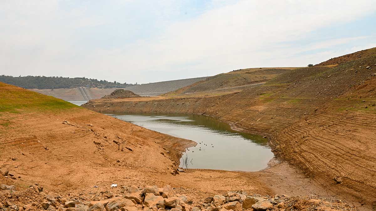
[OROVILLE, Cali] – (MTN) Lake Oroville is less than two feet above an all-time low while Lake Shasta is at its fourth-lowest level on record as historic drought grips the western United States. Lake Shasta continues to be shrouded in smoke from the Lava Fire, where the water sits 145 feet below full pool. At 921.93 feet above Sea Level, Shasta sits at about the same level it was in January 2016. Lake Oroville is at 646.63 feet, just 19 inches higher than a record set in 1977.
At Oroville, operators need to continue water flowing to support fisheries and farmers in the San Joaquin Valley that rely on water from the Sacramento River for irrigation. The river is already dealing with record high temperatures that have devested wild salmon, and the intrusion of saltwater upstream adding pressure to the ecosystem and farmers.
[Best_Wordpress_Gallery id=”61″ gal_title=”Historic Drought in the Southwest”]
The historic low levels have forced over 140 houseboats out of the lake, and only one temporary gravel boat ramp remains operations around the entire lake. Even that ramp is in danger of closing as the level is expected to continue to drop another 25 to 30 feet by October.
The Edward Hyatt Pump-Generating Plant is capable of generating 132 megawatts of power during peak operation. Although up to 17,000 cubic feet of water can flow through the plant per second, approximately 6,000 cubic feet can be recovered and pumped back into the lake. The outflow is captured in additional reservoirs to be sent into the Sacramento River basin and support the needs of farmers to the south. Under extreme conditions, water is sent out to the Yuba River. The water level is expected to reach what hydrologists call deadpool, and the hydro plant may have to close for the first time in its 53 year history.
Lake Shasta, outside of Redding, sits below the headwaters of the Sacramento River and also generates hydroelectricity.
To the north outside of Klamath Falls, over 300 homes have had their private wells run dry, leaving residents without water for farming and personal consumption. Demand for water delivery and drilling companies has driven up costs and lead time, while some communities are providing water at pickup points. Ranchers and homeowners are looking to drill deeper, but after twenty-two years of mostly drought-filled years, there are no assurances those wells won’t run dry.
In the Klamath, a perfect storm of climate change, overutilization, treaties with first nations, and too many promises by government officials have come to head. Some have resorted to stealing water from the district, with complaints of illegal marijuana farms in the area. In this hardscrabble area with an undertone of independence and anti-government sentiment, other operators are also taking water pitting neighbor against neighbor.
Tule Lake on the Oregon-California border is divided into four regions. The most visible at the beginning of the road to Lava Beds National Monument has been allowed to drain dry. The soil deeply cracked and baking under the relentless heat. In the early 1900s, Tule Lake was significantly drained to create the farmland that surrounds the area today. Operators elected to let the most visible part of the lake complex run dry, in an attempt to convert it into a more productive marshland when and if the water returns. Area residents are skeptical and some are complaining about dust and irritation coming from the evaporating mud puddle.
To the north Upper Klamath Lake is the largest freshwater body in Oregon. The shallow lake has suffered from declining water quality for decades, both from natural and manmade influences. In 2001, water was cut off from farmers by the Bush Administration to protect native suckerfish that are on the endangered species list and protect area salmon per First Nations treaties. The impact was devastating to farmers who depend, and hold contracts for water rights.
Upper Klamath Lake is shallow – just 8 feet on average and a maximum depth of 50 feet. Although the lake currently sits at 100% of the normal level today, it has been steadily declining since 2019. Increasing temperatures, agricultural runoff, and naturally occurring chemicals turn the lake green with algae blooms.
Farmers aren’t just facing a shortage of water, they are also facing a shortage of forage and feed for livestock. The cost of hay has skyrocketed adding additional pressure on the battered finances for the region. Tariffs, a reduction in international shipping, depressed prices, have forced some to send animals to market early, getting only pennies on the dollar for their efforts while costs keep going up.
In Utah and Arizona, fear and frustration are mounting at Lake Powell. The lake is only inches from setting a new historic low, beating the record set in 2005. Frustrated locals are growing increasingly angry.
Glen Canyon Dam is the second-largest hydroelectric generating facility in the Southwest, only behind Hoover Dam outside of Las Vegas. The dam generates 1,320 megawatts of electricity, enough to power 400,000 homes. Rapid population expansion in Arizona and Utah has driven up demand as the water level continues to decline. A shutoff of the outflow through the dam would cut off a critical electrical source increasing rates, and potentially plunging communities into darkness. Officials believe the water level at Lake Powell will continue to drop until the spring of 2022 and is dependent on significant snowfall in the Rockies to stage any kind of recovery.
Misinformation on the Internet also abounds with complaints that water is flowing out of Lake Powell and Lake Mead unnecessarily and out to the ocean in California. Both lakes are on the Colorado River, which reaches the Gulf of California in Mexico, where international agreements also require water for the nation on the United States border.
In Walla Walla, Washington, city officials have had to tap one of seven wells to supplement the city water supply. Under normal conditions, water would come from Mill Creek, but extreme drought coupled with extreme demand has forced the city to tap the backup supply. There is enough water in the reserves to supply the city for “several years,” according to officials. The area is known for its wine production. Some growers are reporting up to 50% of their crops were lost in a late June heatwave, that saw temperatures soar to 110 to 115 degrees F. This is the second hit in a row for grape producers who saw some of their harvests destroyed last year by “smoke taint” a growing concern as increasing smoke from wildfires in Washington and Oregon start to creep into the region.
In a cruel twist, a heavier than normal monsoon season has sent floods sweeping through parts of Utah and Arizona. The land has become so baked it can’t absorb the water, so flash floods tear through parks, deserts, and communities offering little in the way of adding to the water supply. In Washington and parts of Oregon, it appears rain is coming next week, but lightning will be included in some areas, increasing wildfire risks in regions battered by the confluence of climate change, government policy, and overuse.
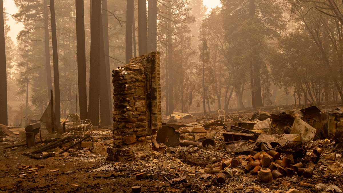
[INDIAN FALLS, Cali] – (MTN) Thick smoke hung heavy in the air creating sepia tones in the hamlet of Indian Falls, California, devastated by the Dixie Fire earlier this week. The tiny village, comprised of less than 10 streets showed the capricious nature and awesome power of nature. As of today, the Dixie Fire has grown to 244,888 acres with thunderstorms in the region whipping the fire into a new fury about 10 miles away, in Quincy, California.
A home would be untouched while the house next door was burned to ash – nothing appeared recoverable in the debris. For the home destroyed, only twisted corrugated metal roofing, half-molten appliances, the occasional chimney, and foundations remained. Fire hoses and couplings laid everywhere, telling a story of firefighters who made a stand until it was completely untenable, dropped hoses, and ran for their lives.
[Best_Wordpress_Gallery id=”59″ gal_title=”Dixie Fire – California”]
Due to limitations with Google News, you will need to view the photo gallery from a web browser if it is not visible.
In the debris, signs of past lives and lost legacies could be found. In what appeared to be the remains of a garage, two massive tool chests were partially buckled, a few drawers had been pushed open from the heat and deformation. Inside some tools were hopelessly damaged, others only blackened by the smoke and heat. At another location, the remains of exercise equipment told a story of a dedicated workout area now lost forever.
An SUV in the driveway left rivers of aluminum on the ground from where the rims and the engine block had liquified. The engine bay itself was empty, the block disappearing in the fire. Only around the dashboard was any molten auto glass left, the rest had vanished. At this house, the fire was over 1,600 degrees F. In what was a garden, everything was gone, except for a metal welcome sign standing only inches from a blackened tree.
On another street it appeared residents tried to save their cars by parking them on the road – it was to no avail. The utility poles had burned through dropping powerlines onto the cars. Only one vehicle survived – an ironically named Triumph TR7 convertible had light damage despite a power transformer landing inches from it, leaking all of its internal oil, that had also caught on fire. Just down the road were the remains of a Buick that had been consumed in the flames. Just feet away from a burned-out Corvette, a fiberglass boat with a canvas cover had not burned but had extensive heat damage on one side.
The air was thick with smoke, and beyond the sound of fire equipment on Route 89 passing by, there was an eerie, post-apocalyptic silence. Biting black flies flitted by. According to the Department of the Interior, smoke flies are attracted to forest fires because they need to lay their eggs in recently burned wood. The scene could be described as Biblical as light ash rained down.
One property was a series of three buildings. The firefighters saved two. On one building, the heat was so intense the front door melted, but the building survived. Five-gallon jugs of Therm Gel, some still full, were on the edge of the road. It was clear that officials prioritized homes over outbuildings. Only a couple of homeowners will be returning to everything untouched. A large home was unscathed, yet 30 feet away the remains of a station wagon told a story of heat approaching 1,600 degrees.
A resident had pulled some kayaks away from their house into a small glade, it was a lucky decision. The fire had burned every area around it, the ground blackened but the flames never reached two small watercraft. At another home, the remains of the kitchen were apparent by shattered pieces of dishes and crocks, and a few heavy metal pots that had survived. On the ground were stacks of rice paper-thin layers of ash, that disintegrated when you touched them.
The items that remained told the story of lost heirlooms and sudden evacuations. A pot still sat on a stove, almost all that remained in the charred foundations of a home. Laying on the back edge of the oven, a horseshoe that likely was hanging on the kitchen wall, that had dumped out all of its luck onto the lone pot.
In parts of Crescent Mills, California, the fire burned so hotly the forest floor and some of the tree snags were white. The ground was covered in a powdery ash a couple of inches deep. In these places, the fire would have been 2000 degrees F. At the base of a hill, the Crescent Hills Community Center laid in ruins. Two hoses were connected to an outside tap, one had melted and burned through. They told a story of a desperate attempt to save anything before the fire consumed the building. Yet with almost everything burned, a four-wheeler ATV under some trees appeared unscathed.
Up the hill on a dirt road, a small compound of cabins had survived. The fire had burned right to the edge of the property, charring the fence and a no trespassing sign. In the distance was a larger home, with an American flag waving in the wind. I rang a makeshift bell as a sign asked but no one answered. Deep holes were all around in the forest where stumps and roots had burned, collapsing the earth. Every step taken was methodical and planned. Underground, fires burning as high as 2000 degrees were coursing through the forest floor, and will continue to burn until the snows come this winter. One wrong step could result in horrible burns.
Further west near Twain, California, firefighter units from around the country were working collaboratively. Units from St. Helena, Beverly Hills, and Culver City were preparing for a potential defensive battle. The battalion commander from Culver City told me they were refilling the pumper truck from Beverly Hills with water, and setting up a defensive position in case they would be needed in the area. Less than a mile away, two fire units from Klamath Falls, Oregon, were also in position. Near the Twain General Store, fire trucks and other equipment moved through at a steady pace to take on diesel fuel and gasoline.
Along Highway 70 and Highway 89, red-stained trees and infrastructure showed where tankers had made airdrops of water and fire retardant earlier. There was no sound of aircraft today with the active fire 12 miles away to the east, and thick smoke making air operations challenging.
According to KPIX in San Francisco, firefighters were battling new downdrafts caused by thunderstorms increasing fire activity. Units are reinforcing tenuous fire lines in anticipation of a shift in the weather, that will bring with it extreme fire behavior.
As ash lightly falls from a silent orange sky, the air thick and stinging your eyes, an American flag waves over the burned-out remains of a house in Indian Falls. The long hot summer and years of drought continue, with the land waiting for the winter snows to bring final containment.
[Seatac, Wash] – (MTN) Our tip line blew up this morning with reports of very light rain from Renton to Everett moving through the area. The marine layer that pushed in overnight made it almost to the Cascade crest, with low clouds all the way to Skykomish. But, as of this writing, the dry streak continues.
No rain has fallen into the rain gauge at the National Weather Service Office at SeaTac International Airport, so for now, rainfall for today is 0.00. It has been 36 days since measurable rain has fallen at the airport, where weather records are kept.
The showers and drizzle moving through the region are very light, barely being picked up by radar, and not enough to move the needle on the ongoing dry conditions.
The longest dry streak in Seattle history was 55 days and happened in 2017. During that dry streak, it rained very lightly on July 27 through many areas of the Puget Sound lowlands, but officially not at SeaTac, which got a trace of rain. July 2017 was the driest month in Seattle history and even if the rain had fallen in the gauge, it is likely it would have remained the driest month in Seattle history.
If SeaTac Airport gets 0.01 inches of rain, the dry streak will end, but that doesn’t seem likely with the marine layer starting to pull back. There is another chance for some mist, drizzle, or light rain showers tomorrow, but I wouldn’t bet money on it.
[SEATAC, Wash.] – (MTN) Seattle has not lived up to its soggy reputation going 30 days without rain, with the last measurable drops falling in the early morning hours of June 14. July is historically the driest month for Seattle, with .60 inches of rain typically falling. The forecast indicates no chance of rain for the next five days, and the long-range forecast suggests the same.
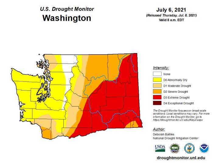
Drought conditions blanket southwest, central, and eastern Washington
The longest dry streak in Seattle history was 55 days, set in 2017. The driest month in Seattle history was July 2017, when only a trace of rain fell into the gauge at SeaTac Airport.
Officials sounded the alarm about growing drought conditions in the Pacific Northwest this spring when March and April were much drier than usual. A burst of sub-tropical moisture made June wetter than average but not enough to help with the rainfall deficit. While temperatures have moderated in western Washington, central and eastern Washington are under a Red Flag Warning and Heat Advisory.
The Northwest Interagency Coordination Center reports 5 large uncontained fires are burning in Washington. The Red Apple Fire near Cashmere exploded to more than 4,000 acres forcing evacuations. A portion of the North Cascades Highway outside of Winthrop is closed due to the Cedar Creek Fire burning outside Mazama. The seven-mile section is expected to be closed through the weekend.
[KIRKLAND] – (MTN) In Canada, 54 wildfires have erupted in the last 48 hours, causing evacuations and burning the village of Lytton, while smoke from wildfires in Oregon and California has already drifted into Washington state – smoke season is here. Smoke density is light to moderate and at higher altitudes, so air quality remains good. Still, forecast models indicating significant smoke will be arriving from the Fraser Valley into Whatcom County and working its way southward on Friday.
NOAA High Resolution Rapid Refresh map showing high altitude smoke blanketing most of Washington state in the next 24 hours
Air quality in western Washington could be called superior today, while many stations in eastern Washington are reporting moderate air pollution. Around Kamloops, British Columbia air quality is unhealthy and deteriorating.
Heavier smoke from Canada is expected to arrive along the Washington border on Friday morning. Weather conditions will keep most of the smoke aloft. Models indicate that smoke may settle into central Puget Sound on Friday night, dropping air quality to moderate levels. At this time, there is nothing in the forecast or model to support dangerous levels of air pollution in the next few days.
The ongoing long-term drought and record setting heat has been devastating for British Columbia forests. Bark beetles have destroyed millions of acres of softwood trees. The beetles hatch simultaneously during periods of high temperatures and voraciously chew their way through trees. The dead trees have no commercial value and have created millions of acres of wildfire fuel.
The worst wildfires in Canada tore through the village of Lytton, British Columbia, yesterday with almost no warning. Residents were ordered to evacuate immediately, and many escaped with only their pets and the clothes on their backs. The mayor stated, “the whole town is on fire,” yesterday. Canadian officials believe the fire was human-caused.
Lytton made international news on Tuesday when the temperature reached 49.6 degrees Centigrade, almost 122 degrees, and an all-time record high for Canada. In contrast, the highest temperature ever recorded in Las Vegas, Nevada, stands at 117 degrees.
In California, the Lava Fire, which was started by lightning, has burned 17,591 acres and is only 19% contained, according to Mount Shasta News. The fire is burning on the outskirts of Weed, California. The Tennant Fire started on Monday and has grown to 8,159 acres and is only 6% contained.
Last night evacuation orders were issued for the residents of Antelope Sink and Bray, California.
In Oregon, Governor Kate Brown declared a wildfire emergency yesterday to provide aid in response to a significant fire near Redmond. Yesterday the airport in Redmond was forced to close due to smoke, and 100 residents in Wasco County received “go-now” evacuation orders. The Wrentham Market Fire has grown to over 10,000 acres. The Bureau of Land Management (BLM) has activated 40 people to help fight the conflagration. According to the Oregon State Fire Marshal, high winds yesterday made fighting the fire a challenge and caused several flare ups. Two buildings have been destroyed, but no homes at this time.
There are no significant wildfires in Washington at this time, but officials from the local to the state level are deeply concerned about the coming Fourth of July holiday and human-caused fires in the coming days. Some communities, such as Bellevue and Mercer Island, have made emergency declarations banning all outdoor fires, including those in approved fire pits and even charcoal grilles. Kirkland opted not to declare an outright ban, but Kirkland Fire Chief Joe Sanford made a public appeal for the community not to have any outdoor fires.
The Pacific Northwest, northern California, and western Canada are reeling after a record crushing heatwave sent temperatures soaring well into the hundreds over the entire region for 3 to 5 days. Heat-related death reports from British Columbia to Oregon now number in the hundreds, and officials were finding people who had died in their homes from apparent heatstroke on Wednesday during welfare checks. Washington state is still analyzing fatality data.
Three-hundred-and-fifty-eight people had to be hospitalized due to heat-related injuries throughout western Washington and over 1,000 were sent to emergency rooms. Hospital officials stated that the patient load was similar to the worst days of the COVID pandemic at the peak of the heatwave.
The National Multi-Agency Coordination Group (NMAC) is at Level 4 preparedness, the second earliest the United States has reached this level.
Central Puget sound has experienced significant wildfire smoke every year except one, since 2015.
[KIRKLAND] – (MTN) The heatwave that roasted the Pacific Northwest isn’t over, with eastern Washington, Oregon, and Idaho facing all-time record highs on Tuesday. For the western side of the Cascades and Siskiyous, things will be closer to normal except the central lowlands and southwestern Washington, where highs will be 15 to 20 degrees above normal.
Here is a list of new all-time records that were set during the heatwave, which continues in eastern Washington and Canada:
Washington All-Time Highs
Richland – 118 degrees June 29, which ties the all-time record high for the state of Washington with Dallesport Airport on June 28 and Ice Harbor Dam, the original record holder
Dallesport Airport reached 118 degrees which tied the all-time record high for the state of Washington
Bellingham – 99 degrees
Hanford – 115 degrees
Hoquiam – 103 degrees
Olympia – 110 degrees
Quillayute – 110 degrees
Seattle – 108 degrees
Spokane – 109 degrees June 29
Vancouver – 115 degrees
Oregon
Astoria – 101 degrees (tie)
Corvallis – 110 degrees
Eugene – 111 degrees
Hermiston – 117 degrees June 29
Hillsboro – 114 degrees
Hood River – 109 degrees
McMinnville – 114 degrees
Medford – 115 degrees
Pendleton – 113 degrees
Portland (Airport) – 116 degrees
Redmond – 110 degrees
Roseburg – 114 degrees
Salem, Oregon reached 117 degrees, which is the highest temperature ever recorded west of the Cascade Mountains in Oregon or Washington
Troutdale – 116 degrees
California All-Time Highs
Yreka – 109 degrees (tie)
Sandberg – 107 degrees
Canada All-Time Highs
Lytton, British Columbia set an all-time high of 121 degrees (49.6 C) which is also the highest temperature ever recorded in Canada on June 29, breaking the record set on June 28
Nahanni Bute, Northwest Territories – 101 degrees, which is an all-time record for the Northwest Territory
Tuesday, June 29, 10:15 PM: No further entries to our heatwave 2021 live blog.
Tuesday, June 29, 9:45 PM: What a difference a day makes. Twenty-four hours ago, it was still 100 degrees after the hottest day in Seattle history, with multiple weather records smashed from Canada to California. The marine layer chose violence today and said not today to the heat for the lowlands. SeaTac Airport topped out at 84 degrees, well below the forecast. Our south Juanita weather station came in at 87. Tomorrow will be even cooler, and there is a chance our 80+ degree streak will end.
On the subject of I choose violence, the heatwave did not end for Pacific Northwest or Canada. Multiple weather records were smashed, with Canada recording their highest temperature ever, 49.6 degrees Centigrade, in Lytton, British Columbia. Washington state tied the state record for the hottest spot in state history, with Richland reaching 118 degrees. Two other locations reached 118, including Sol Duc on Tuesday, but we consider that report to be suspect. If you see anyone saying Renton reached 120, that is incorrect – it was an error in recording data.
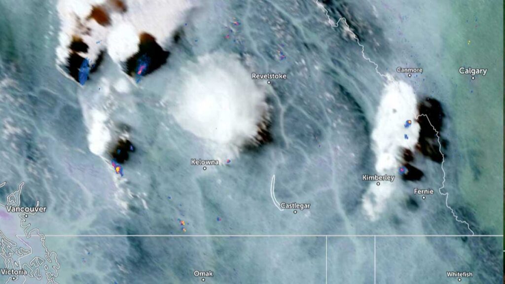
Also, in British Columbia, the province exploded in wildfires today. Here is a satellite image from 2:30 PM today. You can see a plume of wildfire smoke center left, due west of Revelstoke, and a spot of smoke northeast of Kelowna.
British Columbia 2:30 PM Visible Satellite image
This is the image at 6:30 PM today:
British Columbia 6:30 PM Visible Satellite image
Air quality warnings are already posted for parts of British Columbia, but so far, most of this smoke is at higher altitudes. The BC Wildfire Dashboard is reporting 22 new wildfires in the last 48 hours. We will be writing more about the situation north of the border. We would recommend not throwing out those N-95 masks. Washington state is now a change in wind direction away from smoke blowing into our state.
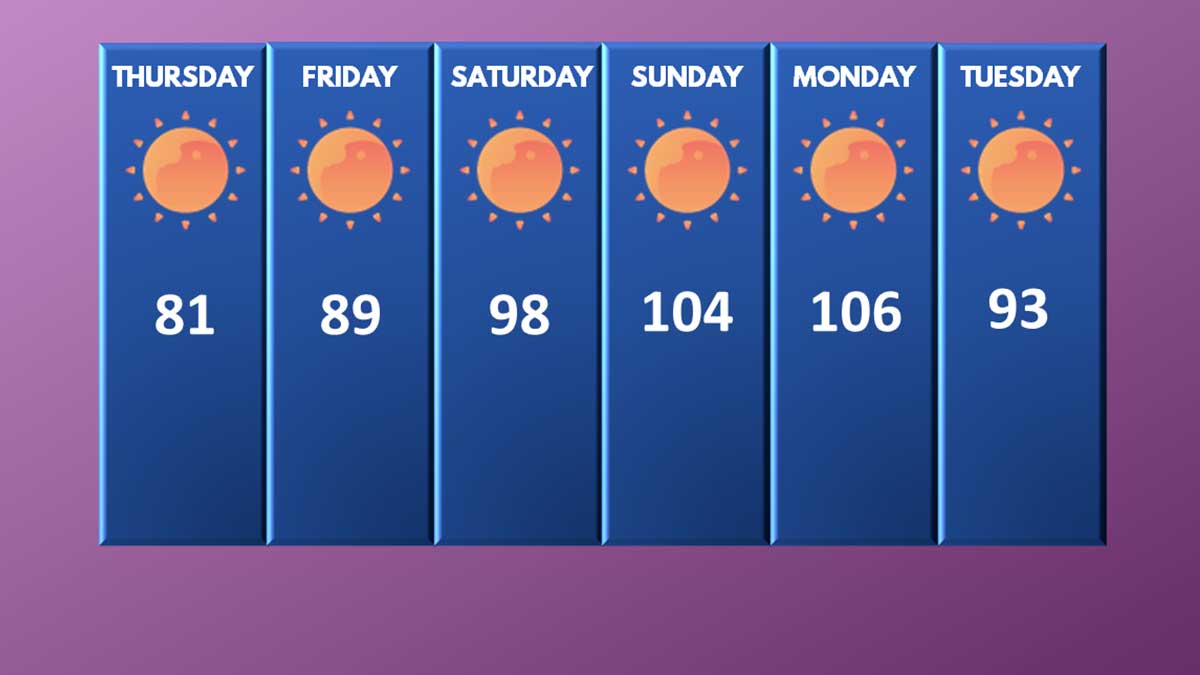
So how did we do against our original forecast from 7 days ago:
Malcontent News original forecast from Wednesday, June 23, 2021
Thursday, June 24: Forecast 81, actual 82
Friday, June 25: Forecast 89, actual 87
Saturday, June 26: Forecast 98, actual 102
Sunday, June 27: Forecast 104, actual 104
Sunday, June 28: Forecast 106, actual 108
Tuesday, June 29: Forecast 93, actual 84
How many times have we said forecasting beyond five days is throwing darts – a lot! I’ll close out this entry saying we feel we served our community well with accurate forecasts and up-to-date information.
Tuesday, June 29, 9:45 AM: This will be our second to last entry in the heatwave blog, barring some major news events related to the heatwave.
Last night the temperature at KSEA dropped 36 degrees in 3 hours as a south wind signaled the arrival of marine air into Puget Sound. The drop in temperature was pretty amazing:
10:00 PM – 98 degrees
11:00 PM – 82 degrees
12:00 AM – 71 degrees
1:00 AM – 66 degrees
2:00 AM – 64 degrees
3:00 AM – 63 degrees
4:00 AM – 62 degrees
The marine layer even made things mostly cloudy for some areas in Puget Sound, including SeaTac Airport. In contrast, on Sunday night it was 81 degrees at 3:00 AM!
The high pressure system continues to drift eastward slowly, and the lowlands will still be hot today. Our weather station bottomed out at 65 degrees, so our forecast was off by 4 degrees. The marine air didn’t get quite as entrenched on the eastside so evening temperatures didn’t cool down as quickly. When SeaTac was reporting 71 at midnight, our station was showing 80.
For our “storm chasing” yesterday we actually chose right going to Maple Valley, which wins the distinction of the highest temperature from a NWS recognized temperature source – 118 degrees. Issaquah came in second place at 116. We noted yesterday our station reported 111, but we are in sight of Lake Washington and are just close enough to get some cooling benefits. Totem Lake less than 2 miles away was 114.
The Cedar Hills Fire in Issaquah is still burning and did not grow past 30 acres. Crews worked to contain the lines last night and more resources along with an additional helicopter is being brought in. The cool weather certainly helped.
I’m not feeling completely confident that we’ll reach 91 today and I’m going to tweak the forecast – but the models support it and the models have been very accurate. People with Ph.D next to their name will be studying this heatwave for years to come.
A closing thought. Dismissing what happened as a weather “anomaly” within a few degrees of normal isn’t the correct way to view this. I have written many times, weather is not climate, and climate is not weather. A series of all-time record highs from the Yukon Territory of Canada to Yreka, California does not on its own provide proof of climate change.
In the month of June we have seen:
A historic tornado in the Czech Republic that dropped baseball size hail and killed 5
4 named tropical storms before June 30 – tying the most named storms this early in the season in what appears to be another active hurricane season
Our heatwave coupled with the one starting in the New England states
Drought from Washington to Minnesota to Texas to California that hasn’t been this severe in 1200 years
Massive flooding in Detroit
Some of the biggest snowstorms Australia has seen in decades
That’s is just a short list of global weather extremes pointing to a climate crisis. Human beings can’t live in areas above 50 Centigrade without massive infrastructure. At 50 C the tolerance of our ability to survive declines, and once you get tropical humidity, survival becomes impossible. Going outside, even for healthy people, for hours at a time is dangerous at that temperature. The high temperature in Canada yesterday was 48 C.
In Whatcom County, the blueberries literally cooked on the bushes ruining the upcoming harvest. The choices everyone makes will have a major impact on our future.
P.S. – we will be reporting on the cookies shortly.
Monday, June 28, 10:25 PM: A lot to write about!
Numerous power outages are impacting 10,887 customers across Seattle City Light, Puget Sound Energy, and Snohomish County PUD. The biggest impacted area is between Carkeek Park and the Seattle Golf Club, roughly west of Greenwood Avenue. This impacts 4,500 customers, and power isn’t expected to be restored until 2 PM on Tuesday.
Two lanes are closed on I-5 northbound at milepost 132. A panel of concrete road surface buckled during the start of the heatwave, and the temporary repair has failed. The damaged area started to shed chunks of concrete, forcing the closure. Repairs cannot start until the weather gets cooler.
The Red Flag Warnings for the Cascades were allowed to expire as the Haines Index is declining for the region. However, air quality is expected to decline again tomorrow, and an Air Quality Alert will likely be issued.
The Excessive Heat Warning was allowed to expire for many areas but continues tomorrow for the central lowlands. You can read more in the forecast section. Although marine air arriving and the thermal trough leaving will drop temperatures 15 to 20 degrees from Monday, most locations will be over 90 tomorrow with more humidity.
Because tomorrow is forecasted to be 15 to 20 degrees above normal (versus the 35 to 40 degrees above normal for Kirkland today), Kirkland will have cooling centers open tomorrow.
The Cedar Hills Fire in Issaquah has grown to 30 acres but could be described as “under control.” The state is bringing in more resources tomorrow and a third helicopter. Light winds and lower temperatures will help keep the fire from spreading, and the danger to people, property, and the power transmission lines has been mitigated for the evening.
The city of Bellevue has issued a citywide burn ban, including fires in what would be “approved” metal or concrete fire pits. Only sealed burners on grilles and outdoor gas-powered fireplaces are allowed due to the growing fire danger. The city of Kirkland is mulling over a similar ban.
Monday, June 28, 8:00 PM: 2,930 customers are without power near Eatonville including Northwest Trek. There are now 158 outages impacting 11,757 customers.
Monday, June 28, 7:25 PM: The all-time record high for Seattle is in the books and it came in at 108. Cairo, Egypt was 99 degrees today and Phoenix, Arizona reached 108. Riyadh bested Seattle with a high of 114, but Portland outcooked the Saudi Arabian city with an all-time record high of 116. Relief is coming but tonight will be beyond unpleasant for the 60% to 65% without access to air conditioning. Our south Juanita weather station topped out at 111.4 degrees – so that is 111 in the record books. We were off 3 degrees on our forecast.
Some hotels in Seattle were charging up to $997 a night to escape air conditioning, and we found the Fairmount Olympic charging $717 tonight.
Puget Sound Energy is dealing with 148 outages impacting 9,757 customers. These are mostly equipment failures impacting small clusters of customers. Power has been restored for most customers in Auburn and Lake Tapps.
A lowland wildfire is burning in Issaquah near Maple Valley. The fire started around 1 PM today and aligned with our observations of smoke-tinged haze in the area during our lunch break and gummy bear melting at Arby’s. Eastside Fire & Rescue is reporting the fire burning near Maple Hills Elementary has expanded to 30 acres. A State crew and a helicopter have been brought in to fight the blaze which is very close to major transmission lines.
Seattle has broken or tied 13 weather records in the last 72 hours.
Sound Transit is reporting that light rail will be operating at reduced speeds for at least a few days because the rails are so hot. Riders of light rail should anticipate delays.
Now if you excuse me, I have cookies in the “oven” I need to go check on.
Monday, June 28, 5:05 PM:KOMO is reporting that the city of Bellevue has instituted a citywide total burn ban. This includes “approved outdoor recreational fire pits” that meet code. Only controlled flames such as from gas barbeques or fireplaces are approved. The ban is indefinite due to the increasing fire danger.
Monday, June 28, 4:40 PM: Avoid southbound I-5 north of 130th. The pavement has buckled from the heat resulting in multiple lane closures. We’re surprised it hasn’t happened sooner in the area.
And here we go.. We have some buckled pavement on southbound I-5 at NE 130th St. Two right lanes are currently blocked. IRT is on scene. Please remember to move over, give us space, and slow down! pic.twitter.com/WYrHAomnqi
the pavement has buckled from the heat on interstate 5
Monday, June 28, 4:25 PM: Is it hot enough to cook an egg? The answer is almost. The yolks cooked through on the one we put on the pavement, the whites cooked a little bit along with the yolk in the one we put in a pan we let preheat on the pavement for 15 minutes. We’re now testing to see if you can bake cookies on a 155 degree dashboard of a vehicle that was parked all day.
Can you cook an egg on the pavement or in a pan? almost.
KSEA has reached at least 106 today with about 60 to 90 more minutes of heating before you can say, “that’s all folks.” A west wind has blown for most of the afternoon moderating temperatures that were earlier today, almost certain to break 110 degrees. The push of the cooler marine air got further inland.
However, the hot spot after hours of “storm chasing” today is Kirkland-Bellevue-Woodinville (congrats for the home team) with temperatures from 109 to 114 degrees through the area. Our south Juanita weather station is showing 111 degrees with maybe another degree to go, we’ll see.
Puget Sound Energy is dealing with 139 spot outages impacting 7,658 customers. Large swaths of Auburn, east of SH-167, and Lake Tapps have been without power since 2:30 today.
Snohomish County PUD has asked their customers to conserve electricity and for those with air conditioning to set thermostats to 78 degrees. The utility does not anticipate rolling blackouts or service interruptions, but it is hitting the limits on its capacity.
Marysville has established mandatory emergency water restrictions after a well pump failed, reducing the available water supply for the town. The restrictions are in place until further notice.
Monday, June 28, 3:05 PM: It is egg frying time, maybe. We’ll be trying shortly at the Village at Totem Lake. It appears Bellevue-Kirkland is going to win the heat medal for the day for our region. Multiple local stations are reporting from 109 to 114. We are seeing 113 at Totem Lake Mall, unofficially. SeaTac Airport is up to 106 degrees a new all-time high, despite a cooling west wind.
There is a major power outage in Auburn impacting over 10,000 customers and Snohomish County PUD is asking their 22,000 customers to conserve electricity. We’ll have more a bit later.
Monday, June 28, 12:48 PM: We are storm chasing and in Covington right now where it is 108 degrees. SeaTac Airport hit 102 officially before noon, not only making this our 3rd day in a row over 100 for the first time in history, but the earliest in the day that Seattle has reached both 90 and 100 degrees.
All of the computer models are in solid agreement it will be 110 to 115 today along the I-5 corridor, and that may be too conservative for places like…Covington, which still have 4 hours of heating to go.
It is oppressively hot.
Monday, June 28, 2021, 10:50 AM: It is already 95 degrees at KSEA. In the garden section at Fred Meyer in Totem Lake, all the thermometers were showing 96, and the panel on trashcan by the entrance was so hot it left my hand stinging for 5 minutes.
We are getting ready to go live to storm chase around 11 AM. We’ll be cooking eggs on the pavement, melting Gummy Bears, and more.
Monday, June 28, 2021, 9:07 AM: Well that didn’t take long. Seattle has already set a record high with a northeast wind gusting to 25 MPH. Before 9:00 AM it was 93 degrees, a new record for the day and I’m confident I don’t need to dig into a record book to type this – the hottest it has ever been at 9 AM in Seattle history. Seattle has now tied for the longest streak over 90 degrees in the month of June, which was 3 days.
Monday, June 28, 2021, 8:40 AM: Let’s start off with last night, it was COOLER then Saturday night with a low of 72 degrees. Here are the temperatures last night:
11:00 PM – 85
12:00 AM – 82
1:00 AM – 81
2:00 AM – 81
3:00 AM – 81
4:00 AM – 78
5:00 AM – 72
6:00 AM – 73
7:00 AM – 79
8:00 AM – 90
No, that isn’t a typo. It was 90 degrees at SeaTac Airport at 8:00 AM today. The dewpoint is lower than Saturday or Sunday so it feels nicer out if that is possible. The wind went from calm to northeast at 14 MPH with gusts to 18 and turned on that easterly flow. That’s how big of an impact it will have today.
There are three factors coming together to create this historic heat for much of western Washington and the I-5 corridor.
The center of high pressure is drifting a bit eastward, allowing the thermal trough that was parked on the coast to move east, right along the I-5 corridor. A weak low in California is going to drift forward, squeezing the isobars together. These three factors are coming together during the heat of the day, and will create historic heat.
Areas east of I-405 will have the highest temperatures. That’s right Kirkland, we are in the bullseye. Fire risk is going to increase dramatically through the day. Tomorrow gets better – sort of – if you think 91 to 93 is better. Wednesday looks to give us a real marine push.
We will be “storm chasing” today and on the air by 11 AM.
Sunday, June 27, 2021, 10:20 PM: Power is out for 3,127 Puget Sound Energy customers in Kirkland as the heat taxes the electrical grid. The challenge isn’t capacity, there is plenty of electricity. The transmission lines and points are heating up, making it harder for them to push power along the cables. If the voltage becomes too low, the substation “trips.” Puget Sound Energy has no ETA for power restoration.
Sunday, June 27, 2021, 8:45 PM: Here we are, at the precipice of plunging into the hottest day in Seattle history. There is nothing left in the thesaurus to describe how historic tomorrow will be.
The ridge of high pressure has been relentless and the thermal trough, which was parked just off the coast is going to drift eastward tonight. Tomorrow the trough will be parked along the I-5 Corridor, creating a “classic heatwave” weather pattern. Wait, you mean it gets worse?
Tomorrow’s model will produce easterly winds coming off the Cascades. Tomorrow’s forecast for Snoqualmie Pass? 101 degrees. As that air flows west toward the Puget Sound lowlands it will compress, squeezing out moisture and getting hotter.
Debating whether the high will be 110 or 115 is like debating if it will snows 24 inches or 28 inches. Although there are meteorological implications, it is a debate on how awful is awful. The UW models are indicating 113 to 116. The GFS is forecasting 116 for SeaTac and 109 for Kirkland. That’s a bit unusual. With easterlies, the communities east of I-405 are generally hotter than west of I-5. Every ensemble model we can look at is showing at least 110 – so the debate is academic. We’ve added another degree for our high temperature for tomorrow and upped the “low” for tonight. We believe the low will be an unimaginable 76 degrees and the high tomorrow 114.
Here is what to look for – what is the temperature at 7 AM Monday morning. Add 30 to 35 degrees to that, and that is a very rough guess on what the final high will be. Sunday morning it was 76 + 30 = 106 – actual was 104. This isn’t a scientific approach but it is better than throwing darts.
If you’re wondering about fire danger, it has increased dramatically. The National Weather Service discussion today indicated that the Cascades of eastern King, Pierce, and Lewis County will receive a Red Flag Warning tomorrow. The Haines Index is a value that indicates the probability a large wildfire could erupt. Parts of the South Sound are at a 6, which is as high as the Haines Index goes. People pulling trailers need to make sure safety chains aren’t dragging, and smokers should not throw cigarette butts out. Brush fires along our highways can start very easily now.
There have been over 120 power outages among Puget Sound Energy and Seattle Power today. Most of these were small, with Issaquah having the largest outage impacting up to 12,000 customers. This isn’t an issue of capacity, there is plenty of electricity. Extreme heat taxes electrical systems and any equipment that was borderline is giving up. These small outages are beyond frustrating for those who have experienced them, but there is nothing to indicate to that Puget Sound Energy, Seattle Power, or Snohomish County PUD is having a capacity issue like those seen in Texas. There is also nothing to indicate a need to shut down transmission lines such as in California.
There were at least 3 drownings today at Angel Lake, Lake Washington, and in a private swimming pool on Vashon Island. People are reminded to wear a life jacket if using any kind of watercraft, swim within your abilities, and never swim alone.
About Tuesday – if you’re looking at 93 degrees and going, “sweet relief finally,” we have some bad news. The heat on Tuesday is going to be accompanied by an offshore flow, as cooler Pacific Air finally pushes back into the coast. It may reach 93, but the humidity has the potential to be higher than Saturday.
Past Tuesday the best we can hope for is around 85, which is about 10 degrees above normal. Next weekend could see us back over 90.
Sunday, June 27, 2021, 6:05 PM: The all-time record high set on July 29, 2009, of 103 degrees has been broken. SeaTac Airport reached 104 degrees for a short period of time and has been over 100 degrees for almost 5 hours. The Temperature-Humidity-Index (THI) is making it feel like 107 degrees. Our weather station in south Juanita is reporting 106 degrees (105.6 if you want to get pedantic) as the high. I’ll take being 4/10 of a degree off of my prediction for Kirkland. Highs for the Kirkland-Bellevue-Woodinville area have ranged from 103 to 109.
We aren’t ready to call this “official” until the National Weather Service has so we will wait to see if they put a flag on mount 104, 103, or if a 105 sneaked in for a few minutes.
To quote Hicks in the movie Aliens, “this can’t be happening man, this can’t be happening,” the National Weather Service has extended the Excessive Heat Warning until Tuesday, June 29, until 11 PM
In good news the three children in Ocean Shores were successfully rescued after being swept a 1/4 mile out to sea into heavy surf.
In not-so-good news, power is still out for large areas of Issaquah and small parts of Sammamish in 3 separate outages. Power is supposed to be back on shortly for both communities.
We will be looking at the weather models and updating our forecast later tonight.
Sunday, June 27, 2021, 2:15 PM: For the first time in history, Seattle reached 100 degrees or higher in a row. It is 102 degrees and the dew point is an incredible 64 degrees making it feel like 105 degrees.
Sunday, June 27, 2021, 2:15 PM: The man pulled from the water at O.O. Denny did not survive.
Sunday, June 27, 2021, 1:05 PM: Ocean Shores officials are engaged in a surf rescue for 3 children, estimated to be 6 to 12 who have been swept out about a 1/4 mile from shore. The status of the parents/guardians is unknown.
Sunday, June 27, 2021, 12:45 PM: North wind has increased to 16 MPH and it is providing a little moderation of our heat. Will it keep us closer to 100-102?
Sunday, June 27, 2021, 12:25 PM: There has been a reported near drowning of a male at O.O. Denny Park in Kirkland this afternoon. A paddleboarder was pulled from the water and people started CPR. This is breaking news.
Sunday, June 27, 2021, 11:20 AM: Seattle beat the old record high of a paltry 91 degrees at 10:45 AM when KSEA reached 92 degrees. High temperature for the day is around 6 hours away.
Sunday, June 27, 2021, 9:30 AM: King County Sheriff is reporting an apparent drowning on Lake Washington yesterday after a man fell out of a boat. Officials are still searching for the victim.
Sunday, June 27, 2021, 9:15 AM: It is 85 degrees at KSEA at 9:00 AM. This is 5 degrees hotter than 24 hours ago. Seattle was under 80 degrees for about 5 hours in the early morning. The dew point is 63, so the humidity is a touch lower than yesterday.
Sunday, June 27, 2021, 8:45 AM: The list of power outages has been updated.
Sunday, June 27, 2021, 7:05 AM: The list of cooling centers has been updated.
The National Weather Service upped the official high yesterday to 102. There is a reason why we say “unofficial high” or “unofficial low” before the record is set. We’ll write about it in another blog when things aren’t so hectic.
Sunday, June 27, 2021, 5:45 AM: For the 60% to 65% who don’t have air conditioning, last night was probably extremely unpleasant. The official temperature reports out of KSEA have us in disbelief.
9:00 PM – 88
10:00 PM – 85
11:00 PM – 83
12:00 AM – 85? Yes the temperature actually went up at midnight!
1:00 AM – 85
2:00 AM – 82
3:00 AM – 73
4:00 AM – 76
5:00 AM – 77
Our low temperature was equivalent to the normal high. 73 is listed as the official minimum. We’re upping the forecasted high for today to 106 and for Monday to 113.
A new record was set today for the all-time maximum low of 73 degrees, breaking the old record by 2 degrees. Don’t worry, that record will likely last about 24 hours.
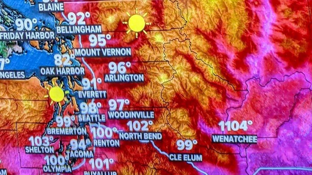
Saturday, June 26, 2021, 7:20 PM: We’re going to have a little laugh at KING 5’s expense. Apparently, Wenatchee opened the portal to Hell today by accident or someone fat-fingered the graphics. We are hoping it is the latter!
Someone made a mistake on the temperature graphic with Wenatchee reporting a balmy 1,104 degrees
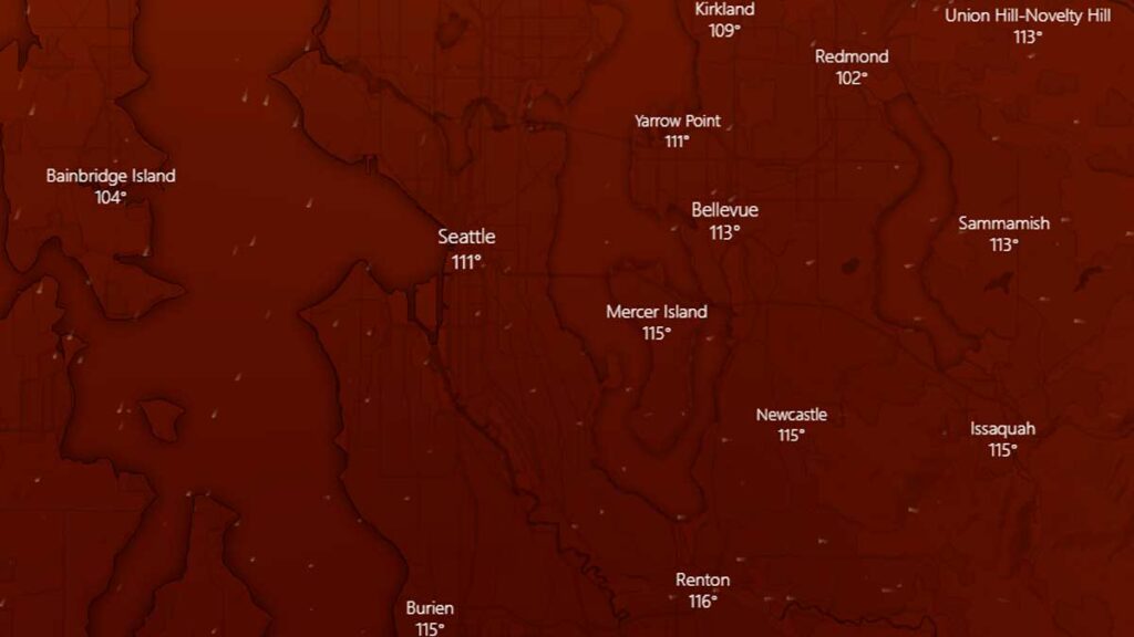
Saturday, June 26, 2021, 6:40 PM: I’ve been diving into weather models. I’m pretty sure Holy $h1T isn’t an acceptable meteorological term. The GFS Ensemble forecast for Monday is – unimaginable.
GFS Ensemble Forecast for Monday, June 24, 2021, 4 PM
118 degrees at SeaTac Airport, 111 degrees downtown Seattle, and although you can’t see it 111 in Kirkland. Tacoma is also forecasted at 118 degrees. This is incredible and in a word, terrifying, as it is credible. We are not prepared to make a forecast of 113 in Kirkland and 120 at SeaTac Airport, but we will be pouring over models tonight and early tomorrow morning for Monday.
The GFS forecasted a 102 for Seattle today, and it was 1 degree off. Interestingly it is forecasting 100 degrees for tomorrow, which we think is low. Which adds to the, this can’t possibly be – possible.
Saturday, June 26, 2021, 6:10 PM: Seattle peaked out at 101 degrees today. KSEA has dropped to 100 degrees. Our weather station in south Juanita reported 102 degrees as a high (2 above our forecast). A number of locations on the eastside were reporting up to 105. This is the coolest of the 3-day run. This is what we have learned. The weather models were correct, and this wasn’t some glitch in the weather forecasting matrix. We have written how the models don’t capture the easterly flow well and tend to run conservatively. What is amazing is we had a north wind develop today and under normal conditions, it would have helped moderate temperatures. I’m running out of words in the thesaurus to describe this event. We’re holding our forecast for tomorrow of a high of 105 – and we think it will be spot on. Tonight is going to be in a word, miserable, if you don’t have air conditioning. We think the forecasted low of 70 is conservative, and we’ve bumped it up. The weather forecast, weather record, and wildfire sections have been updated.
Saturday, June 26, 2021, 4:15 PM: Multiple records were crushed this afternoon as SeaTac Airport soared to 101 degrees. It is only the fourth time Seattle has reached 100, and the earliest it has ever happened. The dew point is 62 making it feel like 103. Another hour of heating is left making it possible Seattle could tie or break the all-time high of 103.
Saturday, June 26, 2021, 3:05 PM: it is 98 degrees at KSEA and the dew point dropped to 63, it feels like 100 degrees. Two hours of heating left, 100 plus is all but certain.
Saturday, June 26, 2021, 2:05 PM: it is 96 degrees at KSEA and the dew point is still 66, it feels like 99 degrees. Three hours of heating left.
Saturday, June 26, 2021, 1:15 PM: it is 92 degrees at KSEA and the dew point is 66. THI makes it feel like 95. Four to 5 more hours of heating left today. 100 remains very likely. 89 to 97 theough our area. Remember, this is the “coolest” day.
Saturday, June 26, 2021, 12:45 PM: it is 90 degrees at KSEA and the dew point increased to 66.
Saturday, June 26, 2021, 12:15 PM: it is 88 at KSEA and the dew point is 65. This is east coast, Mid-Atlantic states in August weather. Easily another 10 degrees of heating today. The official low at KSEA hit 69. We will update our graphic.
Saturday, June 26, 2021, 10:45 AM: List of cooling centers has been updated.
Saturday, June 25, 2021, 10:00 AM: The temperature has already soared to 85 degrees at KSEA with 7 to 8 hours of warming to go. 100 degrees seems highly likely. The dew point is a stunning 64 degrees making it feel oppressive. This morning when I walked out the door it reminded me of Houston.
The high dew points are shocking.
Saturday, June 25, 2021, 6:20 AM:Road closure section updated.
Saturday, June 25, 2021, 6:15 AM: Any doubts about the computer models not getting this right disappeared early this morning. The unofficial low at KSEA was 70 degrees, one degree short of tying the all-time record for maximum low. This was 3 degrees above forecast, which means we’re already off to an early start. Last night the north wind fizzled out and a light easterly flow started. Current temperature is 72 degrees so we’ve hit the basement and going up. Expect a good 30 degrees of warming today, so 100 degrees is highly likely. Our weather station in south Juanita reported a low of 67 degrees, which was right on the money.
We have updated the forecast graphic to reflect the actuals for Friday. We are leaving the forecast through Tuesday unchanged.
Friday, June 25, 2021, 9:40 PM: OK, this is almost certainly the last entry. At 12:50 PM it was 82 degrees at SeaTac Airport. The high was 87, 1 degree above the NWS forecast. At 9:17 PM the temperature at SeaTac was 82 degrees. In the last 9 hours, the temperature has only moved 5 degrees up or down. The heat pump has started up and we enter the first day of a historic hot streak about…now. Lows tonight at SeaTac will be 66 to 68. We’re sticking with our forecast for the eastside of 67 to 69.
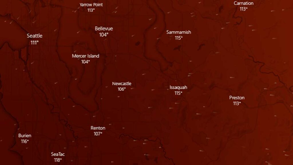
Friday, June 25, 2021, 9:30 PM: Probably the last entry for tonight. It is going to be insanely busy the next 3 days. This is the GFS Ensemble forecast for Monday, at 3 PM. Bellevue at 113, Seattle at 111 (city not airport), Renton at 116! What isn’t on this graphic is the project high temperature for Snoqualmie Pass – an unimaginable 100 degrees.
GFS Ensemble Forecasted Highs for Monday, June 28, 2021
Friday, June 25, 2021, 9:20 PM: List of cooling centers has been updated.
Friday, June 25, 2021, 7:00 PM: We are feeling confident about our forecast for Saturday and Sunday. The models are indicating Monday could reach 113, but we’re just not convinced. We’ll hold off for another 12 hours to see if we need to make an adjustment or not.
Friday, June 25, 2021, 6:15 PM: Might have typed too soon, KSEA is back up to 87 degrees and the humidity dropped a little more, could there be a stretch to 88? We’ll see.
Friday, June 25, 2021, 5:30 PM: The unofficial high temperature at KSEA is 87 degrees. Won’t become “official” from a meteorological stand point until tomorrow. That was within our forecast for today on the low end. Our weather station in south Juanita is 88 degrees.
Friday, June 25, 2021, 4:45 PM: KSEA is at 86 degrees, our weather station in south Juanita is reporting 87 degrees. A north wind at 9 MPH is holding temperatures down slightly at SeaTac. The heat of the day will come in the next hour.
Friday, June 25, 2021, 2:40 PM: Have a flight out of SeaTac Airport between now and Tuesday? You might want to be prepared for delays, especially Sunday and Monday. Hot air reduces the amount of lift an airplane can create because the air is “thinner.” This requires longer takeoff rolls and landing at higher speeds, both can slow down airport operations.
Friday, June 25, 2021: 2:15 PM: Model runs indicate the forecasted highs for Sunday and Monday, along with the forecasted low for Sunday night are likely conservative. As we get closer to these dates the confidence in the forecast models gets higher. We may adjust our forecast later tonight to add a couple of degrees to the highs and lows on Saturday, Sunday, and Monday.
Friday, June 25, 2021, 1:45 PM: SeaTac Airport (KSEA) is up to 82 degrees with the clouds mostly burned off. Still about 4 hours of warming to go. Wouldn’t bet against KSEA hitting 90 degrees.
Friday, June 25, 2021, 12:30 PM: Governor Jay Inslee has announced he is lifting COVID-related capacity restrictions at publicly-owned cooling centers due to the weather emergency, effective immediately. Facilities such as government buildings and libraries can operate at full capacity. Capacity restrictions still apply to privately owned for-profit facilities such as malls and movie theaters.
Friday, June 25, 2021, 9:00 AM: The forecast models are leaving mouths agape in the weather community as a ridge of high pressure starts to build. A weak marine layer has been pushed out and we are entering the first day of this historical weather event. It is likely many weather records will be broken over the next 4 to 5 days.
We are off to a warm start with area temperatures in the mid-60s. Seattle-Tacoma Airport (KSEA) low temperature was a balmy 67 degrees in part because of a marine layer that tried to push in last night. The temperature as of this writing is 69 under partly cloudy skies, but on the eastside, those clouds have already burned off.
Forecast models continue to get hotter, especially for Monday. Either every weather computer model is completely wrong and has failed to forecast this scenario, or we are going to make history.
Most Up-To-Date Weather Forecast
Last Updated: Tuesday, June 29, 2021, 10:15 PM
The National Weather Service has EXTENDED the EXCESSIVE HEAT WARNING in effect from 2 PM Friday to 11 PM Tuesday. Impacted areas include Western Whatcom County-Southwest Interior-Western Kagit County-Everett and Vicinity-Tacoma Area-East Puget Sound Lowlands-Bellevue and Vicinity– Seattle and Vicinity-Cascades of Whatcom and Skagit Counties-Cascades of Snohomish and King Counties-Cascades of Pierce and Lewis Counties-Including the cities of Bellingham, Olympia, Lacey, Tumwater, Mount Vernon, Anacortes-Sedro-Woolley, Burlington, Everett, Edmonds, Lynnwood, Marysville, Tacoma, Covington-Sawyer-w, Maple Valley, Monroe, Prairie Ridge, Enumclaw, Bonney Lake, Woodinville, Redmond, Kirkland, Bothell, Kenmore, Newport Hills, Sahalee, Pine Lake, Seattle, Concrete, Lyman, Hamilton, Darrington, and Morton
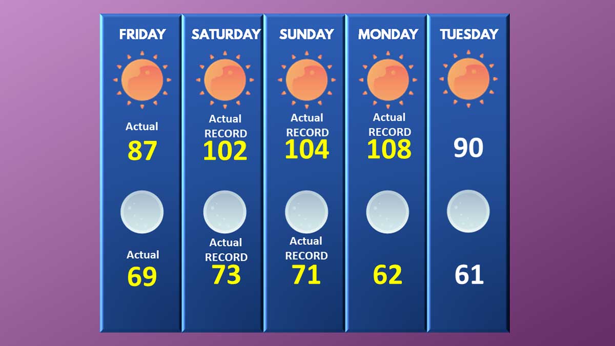
Friday: Today will be considered hot by Puget Sound standards. High temperatures will be 87 to 92 degrees, but this is only the beginning. Kirkland-Bellevue-Woodinville target – 90 degrees.
Actual: KSEA 87 degrees, Kirkland at our south Juanita weather station, 90 degrees
Friday Night: High pressure builds along with a light easterly flow off the Cascades. Lows will be 65 to 69. Kirkland-Bellevue-Woodinville target – 67 degrees.
Actual: KSEA 69 degrees. Kirkland at our south Juanita weather station, 67 degrees
Saturday: Record-breaking heat will blanket the region. High temperatures will soar to 98 to 102 under sunny skies with variable winds. Kirkland-Bellevue-Woodinville target – 100 degrees.
Actual: KSEA 102 degrees. Kirkland at our south Juanita weather station, 102 degrees
Saturday Night Potentially record-breaking with near historically high minimum temperatures. Lows from 70 to 73 under clear skies. Kirkland-Bellevue-Woodinville target – 72 degrees.
Actual: KSEA 73 degrees. Kirkland at our south Juanita weather station, 71 degrees
Sunday: Historically hot. High temperatures will reach a dangerous level for our region with highs of 104 – 108 under sunny skies. Kirkland-Bellevue-Woodinville target – 106 degrees.
Actual: KSEA 104 degrees. Kirkland at our south Juanita weather station, 106 degrees
Sunday Night: Historically hot with low temperatures higher than the normal daytime high, providing little to no relief from the daytime heat. Area lows of 74 to 77 degrees will set all-time records for the highest minimum temperature in regional history. Kirkland-Bellevue-Woodinville target – 76 degrees.
Actual: KSEA 71 degrees. Kirkland at our south Juanita weather station, 73 degrees
Monday: Unprecedently heat. High temperatures will soar to 111 to 116 degrees under sunny skies as the ridge of high pressure moves east and parks the thermal trough right over the I-5 corridor. Kirkland-Bellevue-Woodinville target – 114 degrees.
Actual: KSEA 108 degrees. Kirkland at our south Juanita weather station, 71 degrees
Monday Night: The ridge of high pressure will start to lose its grip on our area and marine air will push in along the coastline. Low temperatures will be 67 to 71, which is still be near normal daytime highs. Kirkland-Bellevue-Woodinville target – 69 degrees.
Actual: KSEA 62 degrees. Kirkland at our south Juanita weather station, 65 degrees
Tuesday: Temperatures moderate but will still be close to 20 degrees above normal. High temperatures will be 89 to 93 under clear skies. Kirkland-Bellevue-Woodinville target – 90 degrees.
Actual: KSEA 84 degrees. Kirkland at our south Juanita weather station, 87 degrees
Tuesday Night: Marine air pushes further inland, with low temperatures of 59 to 63. Kirkland-Bellevue-Woodinville target – 61 degrees.
Weather Records we are Watching
Last Updated: Tuesday, June 29, 2021, 10:10 PM
June 26 record high: 93 degrees – Federal Building – BROKEN – new record 102 degrees KSEA
June 27 record high: 91 degrees – BROKEN – new record of at least 104 degrees KSEA
June 28 record high: 91 degrees – BROKEN – KSEA reached 108 degrees
June 29 record high: 93 degrees – high 84 degrees
June all-time high: 96 degrees KSEA, 98 degrees Federal Building – KSEA BROKEN, FEDERAL BUILDING BROKEN – 102 degrees KSEA June 26
BROKEN, 104 degrees KSEA June 27
BROKEN, 108 degrees KSEA June 28
Seattle all-time high: 103 degrees, July 29, 2009 – BROKEN, UNOFFICIALLY ON MONDAY – 108 DEGREES June 28. This breaks the previous record set on June 27, 2021
Number of times Seattle has reached 100 degrees: 3, 1 at Federal Building, 2 at KSEA – June 26, 4th time and earliest to 100 degrees in Seattle history
June 27, 5th time in history
June 28, 6th time in history
Number of days in a row over 90 in June: 3 TIED – Streak ends at3
Number of days in a row over 90, any month: 5 Streak ends at3
Number of days in a row over 80, any month: 15 Streak is at 6
Number of days in a row over 100 degrees: 1 – Seattle has never had a multi-day streak at or over 100 degrees Streak ends at 3
Seattle all-time maximum low: 71 degrees – KSEA BROKEN, 73 DEGREES, June 27
Earliest to 90 degrees: June 28, 2021, before 8:00 AM
Earliest to 100 degrees: June 28, 2021, before 12:00 PM
Longest amount of time over 100 degrees: June 28, 2021, 8 hours
Brush and Wildfire Reports
Last Updated: Monday, June 28, 2021, 7:35 PM
The Cedar Hills Fire grew from 1 acre to 30 acres in about 6 acres and is located in between Renton, Issaquah, and Maple Valley near the Maple Hills Elementary School. State resources have been authorized to fight the blaze and a helicopter has started water drops. Fire fighters have created a defensive line to protect homes and power transmission lines.
Crews are battling the Lind Fire, close to the town of Lind, Washington, which has burned about 20,000 acres. The fire exploded from 425 acres to 20,000 acres. Level 1, 2, and 3 (evacuate now) orders have been issued.
The National Weather Service discussion on Sunday afternoon indicated that the Cascades of eastern King, Pierce, and Lewis County will receive a Red Flag Warning on Monday. The Haines Index is a value that indicates the probability a large wildfire could erupt. Parts of the South Sound are at a 6, which is as high as the Haines Index goes. People pulling trailers need to make sure safety chains aren’t dragging, and smokers should not throw cigarette butts out. Brush fires along our highways can start very easily now.
S-503 Fire – Warm Springs Reservation – 7 miles northeast of Simnasho, Oregon: The fire is 60% contained and has burned 6,679 acres. The number of acres involved is unchanged.
Power Outages
Last Updated: Sunday, June 28, 2021, 10:35 PM
June 28, 2021, 10:35 PM: About 4500 customers in the North Beach/Greenwood area of Seattle are without power. Electricity is not expected to be restored until 2 PM on Tuesday, marking this the longest and one of the largest area outages of the heatwave. Power has been restored by Puget Sound Energy near Eatonville and Graham.
June 28, 2021, 7:30 PM: Approximately 2,900 customers have lost power near Eatonville and Graham. PSE has no ETA for restoring power at this time. Power has been restored in Auburn and Lake Tapps.
June 28, 2021, 4:30 PM: Auburn and Lake Tapps are experiencing a significant power outage according to Puget Sound Energy, with large areas east of SH-169 without power since 2:30 this afternoon.
June 28, 2021, 8:45 AM: There are over 80 spot outages according to Puget Sound Energy with about 2,100 customers impacted. Power was restored in Kirkland overnight (the largest outage last night). Expect to see numerous spot outages throughout the day.
June 27, 2021, 10:25 PM: 3,127 customers in Kirkland have been plunged into the dark with no AC, fans, or way to cool off. The outages have been caused by multiple small failures and are not due to a lack of capacity to meet electrical needs. PSE does not have an ETA for power restoration.
June 27, 2021, 3:00 PM: Over 120 spot outages have been reported across the entire region between Puget Sound Energy and Seattle Power. The peak number of impacted households was about 12,000, with the largest outage in Issaquah.
June 27, 2021, 3:00 PM: Significant power outage in Issaquah impacting 12,000 customers.
June 27, 2021, 9:30 AM: 3,000 customers without power in Graham due to a car accident.
June 27, 2021, 9:30 AM: Power restored at North Rose Hill.
June 27, 2021, 8:45 AM: There are multiple power outages scattered across the PSE service area. All are small, some just a single address. The largest is the North Rose Hill area of Kirkland and Redmond impacting about 300 customers.
Road Closures and Emergency Repairs
Last Updated: Sunday, June 28, 2021, 4:45 PM
Two lanes are closed on I-5 North at milepost 132 in Tacoma (near the I-705 interchange) due to heat related damage to the road surface. A temporary repair did not hold and the road started to shed chunks of concrete. Repair work cannot start until temperatures drop lower. Avoid the area or bring patience.
Multiple lanes are closed on southbound I-5 at 130th in North Seattle due to the road surface buckling from the heat. No ETA on when repairs will be made. Additional road panels buckled at 145th shortly after the failure at 130th.
State Highway 21 near the town of Lind has been closed due to a 20,000 acre wildfire.
Southbound I-5 from the I-90 off-ramp to Spokane Street is closed (this is by the West Seattle Bridge). This was part of a planned Washington DOT project that is moving forward this weekend. Drivers are being asked to avoid the area and this section of I-5 as possible as significant delays are expected. The closure is through June 28, 2021.
Highway 30 in Oregon close to the Washington border is closed from Simonelli Road to Rowena due to a wildfire outside of The Dalles, near I-84 milepost 76 to 80. Three separate wildfires erupted on Friday, June 25, 2021, and are currently contained but still burning.
Journalists, activists, and researchers defending the First Amendment
Subscribe to Malcontent News
Register to feed your head holes with the Malcontent News newsletter.
Submitting your e-mail address gives us permission to send you e-mails. We do not sell or distribute our e-mail lists or share them with third parties.