Category Archives: Weather

Summer arrives right on time (technically)

[KIRKLAND] – (MTN) Meteorological summer starts on June 1 and the weather gods are smiling upon Puget Sound with warm temperatures ahead.

The entire Kirkland-Bellevue-Woodinville area will see blue skies and temperatures from 79 to 83 degrees. Finn Hill, North Rose Hill, and right along Lake Washington might not pierce 80, while area hot spots like Totem Lake will be warmer.

Tonight will be sleeping weather with temperatures dropping to 55 to 57 degrees under clear skies.

Tomorrow will be even warmer with the entire area getting over 80. Temperatures will be 82 to 86 with abundant sunshine.

Thursday the marine layer will start to push back in, and the region will be mostly cloudy. Highs will be 71 to 74.

Friday is a bit far out, but appears to be pleasant, and 69 to 73 before rain pushes in for Saturday.

A desperately needed drippy week lies ahead

[KIRKLAND] – (MTN) The forecast next week is looking cool and damp after the first 3 weeks of May have produced only 2/3 of an inch of rain and April dropping less than an inch. The first 14 days of 2021 were exceptionally wet, with 5.74 inches of rain falling at Seattle-Tacoma International Airport, before a slow drying out with average rainfall in February, and below average in March.

On Sunday the marine layer will be even stronger than today, with a chance of drizzle over the lowlands. The day will stay cloudy, with some sun breaks in the afternoon and highs below normal from 62 to 65 degrees through the Kirkland-Bellevue-Woodinville region.

Sunday night through Tuesday is looking rather wet, and if the forecast model holds, we’ll exceed April’s rain total by Tuesday morning. Monday will have showers through the day and highs only 58 to 61 through our area. Monday night showers will turn to steady rain overnight, before tapering off Tuesday morning. Tuesday will have sun breaks again in the afternoon, with highs from 61 to 63.

Wednesday through Friday is further out in the weather models, but for now, Wednesday is looking like the best day next week. The marine layer will hold on with clouds in the morning, and then moisture will move back in late during the day. Highs will be 66 to 69, giving us a normal late-day May.

Thursday and Friday are also looking wet.

If you’re wondering about Memorial Day weekend that forecast is too far out to be accurate. For now, the computer models are favorable for Saturday and Monday. The models for Sunday don’t look like a washout, but there is a lot of disagreement on how much moisture will be in the area.

Rain comes on Tuesday as Puget Sound lowlands precipitation deficit grows

[KIRKLAND] – (MTN) Less than an inch of rain fell in April at Seatac International Airport (KSEA) and halfway through May, only .52 inches has fallen so far, and more than half of that on May 4. With temperatures tickling 80 degrees on the eastside today, it is easy to ignore the growing deficit as our dry season inches closer.

Significant drought is already gripping the nation from eastern Washington to Minnesota, south to Texas, and then back west to California. In Los Angeles, the Palisades Fire has grown to more than 1,000 acres with mandatory evacuations ordered in fire-ravaged Topanga. In April, during a near historically early fire weather alert, a dozen fires popped up in western Washington, with one burning in Auburn for almost a week.

Only the Cascade and Olympic Mountains ranges are normal in the state of Washington, as drought conditions grow through the rest of the state

Monday will be cloudy and much cooler, with temperatures in the low 60s. Monday night and into Tuesday morning, rain will move in with .25 inches possible on the eastside. Rain will gradually give way to clouds but some drips are possible into Wednesday morning.

The long-range forecast is more seasonable with temperatures in the mid-60s to around 70, but the dry weather pattern returns. The Puget Sound lowlands get most of its water from snowpack melt in the summer months, and the snowpack was at or near record levels this year.

The continued dry weather will increase wildfire risk as the summer progresses. In 2020 wildfires tore through the western side of the Cascades from Oregon to Washington, shrouding the area in dark clouds of smoke for weeks.

Fire season off to a troubling early start

[PORTLAND] – (MTN) Officials are warning of another historic fire season with large swaths of southern and central Washington already under a Special Weather Statement for unseasonably high fire danger through the rest of this week. A spell of warm weather with low humidity and forecasted offshore flow will create favorable condtions for wildfires in the South Washington Cascade Foothills, the Cascades, the Western and Central Columbia River Gorge, Willapa Hills, Cowlitz County, and the greater Vancouver, Washington area.

Despite near historical levels of snowpack in the Cascades, eastern Washington has experienced drier conditions resulting in the advisory. Large swaths of the country are also grappling with concern climate and conditons data from eastern Washington to Minnesota and from California to Texas. In the heartland, wildfires are burning from Oklahoma to North Dakota, mostly in rural and federal lands.

This is the time of the year to get ready for summer wildfire season and possible smoke.

As we start to approach summer, with another long-range forecast model of, “hotter and dryer than the norm,” now is the time to get prepared.

  • Get some N-95 masks. Due to COVID they remain difficult to secure. If you have allergies, asthma or other breathing issues, you should try and secure a supply now. Small children and those with facial hair can’t use them.
  • Surgical masks don’t block fine particulates, they don’t work for aiding with smoke exposure.
  • Our smoky days typically go hand-in-hand with our hottest days. In 2018 and 2020 we had several days that would have been record-shattering hot, but the smoke kept us in the 90s. Ideally, on the worst days, you should keep your windows closed. Now is the time to consider a portable air conditioner for at least one room, to create a clean air space in your home.
  • Along with a room with AC, having a box fan with a furnace filter taped to the “intake” side (the side that pulls the air) has been shown to dramatically reduce particulate matter in the air. If you can’t afford an AC, a $20 box fan and a $10 filter can significantly improve air quality in a single room.
A furnace filter duct taped to a box fan is a low cost way to clean the air in a single room.
  • When you drive your car run your AC and run it in the “max” or “recirculation” mode. This recycles the air within your cabin. If your car doesn’t have working AC, you’ll need to wear an N-95 mask when driving during smoky days.
  • On the worst smoky days don’t do outdoor activity if you can. If you work outdoors, your employer should provide N-95 masks. This is vital on days where there is ash fall.
  • Exercise should be done indoors in a climate controlled setting. If you have medical issues, to begin with, avoid exercise or better yet, talk to your doctor.
  • Contact wearers should make sure now that their glasses prescription is up to snuff. On the worst days, you’ll want to rip your eyeballs out when you’re wearing contacts.

Winter makes a final stand before spring-like weather finally arrives

[KIRKLAND] – (MTN) If you’re feeling like March and the start of April have been cooler than normal, especially in the evenings, you would be correct. In an average year, Seattle would see its last day with an evening low below 40 degrees on March 20. Sixteen of the last 20 days were at or below normal for low temperatures, and the trend is going to continue into early next week.

Friday will be 6 to 8 degrees below normal, with highs struggling to get to 50 degrees. Tonight will see lows of 35 to 37 with rain coming in overnight. The snow level in the mountains passes will drop to 2,500 feet. With moisture on the way, the west slope of the Cascades is under a Winter Weather Advisory for 4 to 7 inches of snow expected to fall overnight.

Saturday will start damp and clear out for the afternoon, but again, high temperatures will struggle to get to 50 degrees. Saturday night will be cool, with low temperatures in the Kirkland-Bellevue-Woodinville area of 29 to 32 degrees – 10 to 13 degrees below normal, and representing one of our latest area frosts on record.

Back on March 27, we predicted the last frost of the year could be as late as April 11.

Looking further ahead, nighttime lows will remain below average until Wednesday, while the days will be sunny and mild. Our first 70 degree days of the year are in sight on the long-range forecast, with the end of next week looking promising.

Cool weather will persist into the first week of April

[KIRKLAND] – (MTN) By local standards, this past winter wasn’t a hardship, especially for a La Nina year. The forecast models point to a sunny and dry week ahead, but nighttime temperatures will hover at or below freezing during the start of the week. The long-range forecast shows a cooling trend into next week and a wetter pattern.

A common question the gardening community asks us is when will the last frost be. Statistically speaking, we are past the point of having a hard frost (below 27 degrees), and the average date for the last possible frost in the Kirkland area is April 4. Historically speaking, Kirkland has had measurable snow as late as April 11, so temperatures below freezing are still possible deep into April. 

Sunday, Monday, and Tuesday will see lows from 30 to 33 through the Kirkland-Bellevue-Woodinville region. Sunday night will be after a rainy day, so it’s unlikely there will be frost. Monday and Tuesday night look like solid possibilities, so gardeners should plan their planting accordingly. The long-range forecast shows lows in the high 30s through the first week of April.

Our prediction for the last possible day for frost in our region is April 11. If you’re getting tired of the cool weather, don’t despair. By the end of the week, daytime highs will be approaching 60 degrees. 

Springing ahead, literally and metaphorically

[KIRKLAND] – (MTN) Winter will finally lose its grip over the Puget Sound lowlands with a warming trend and Daylight Savings Time ahead. Thursday through Saturday will see a run of sunshine, and 60 degrees over most of the Kirkland-Bellevue-Woodinville area by the weekend. Also, Daylight Savings Time starts on March 14 at 2:00 AM, when we turn our clocks forward.

Thursday will see highs in the mid-50s with abundant sunshine. Due to a lack of cloud cover, lows will drop to between 31 and 35 Thursday night.

Friday will see even warmer temperatures, with hot spots like Totem Lake and downtown Bellevue ticking 60 degrees. Overnight temperatures will drop to 32 to 36 degrees.

Saturday will see almost all areas break 60, with temperatures from 58 to 63 degrees. Clouds will start to roll in by sunset. The cloud cover will act like a blanket, keeping temperatures between 39 and 42, with rain developing.

Sunday is looking like a rainy day, however, high temperatures will be 56 to 59 degrees. If you’re picking a day for outdoor activity, Saturday is the winner.

On Saturday night we’ll turn the clocks ahead an hour, providing daylight hours past 7 PM. Looking at the long-range forecast, it appears we’ll be able to enjoy that extra daylight starting on Monday with no rain indicated until deep into next week.

Yesterday’s weather isn’t very unusual for March

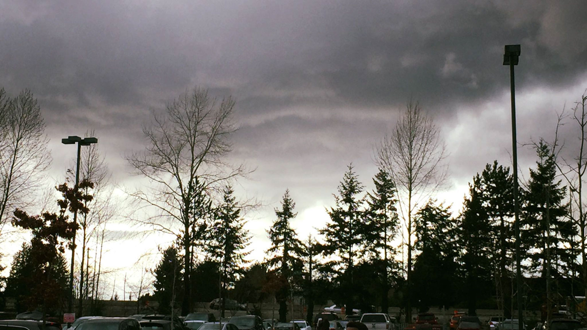
[KIRKLAND] – (MTN) The weather yesterday put on a choose your own adventure show across the region. Torrential rain, gusty winds, graupel, hail, and lightning crashed from black skies followed by periods of calm. Rinse, recycle, and repeat until the evening hours came. The weather may have seemed wild, but it isn’t an unusual March weather pattern. The picture of what is affectionately called a “mothership,” in meteorology? That wasn’t taken yesterday. That picture was snapped on March 6, 2016, in Kirkland!

To produce the wild weather we had yesterday you need moisture, atmospheric energy, and instability. When colder air rides over the top of warmer air, the warmer air wants to rise, and the colder air wants to sink. Throw in our microclimates, terrain, and the Convergence Zone, and you end up with some crazy weather. Warm air rushing up can carry raindrops into the colder air above, which freeze. They fall back down to be carried aloft again and build another layer. Eventually, the frozen raindrops grow so heavy the updrafts can’t carry them anymore, so they fall as hail. The miniature snowballs that fell yesterday are called graupel. Graupel forms when snowflakes at a higher elevation clump together, and are lifted repeatedly by updrafts like hail. The little snowballs reach a weight where they can’t be carried anymore.

Thunderstorms in the Pacific Northwest are unlike those that form in other parts of the country. In the Midwest and even out to the Northeast, supercell thunderstorms can tower 50,000 to 60,000 feet in the air. Here, the Pacific Ocean moderates our temperatures so thunderstorm rarely grow taller than 15,000 to 20,000 feet. The rumbles yesterday were created by the same instability that produced downpours, hail, and graupel. There are exceptions for Pacific Northwest thunderstorm development but they are exceedingly rare. For example, September 8, 2019, had a line of thunderstorms form after dark that would be more at home in Alabama than Washington.

Our bursts of wild lowland weather in March happens because of changing weather patterns as we approach astrological spring (meteorological spring started on March 1) and the Jet Stream starts to shift. The moisture and instability create our wild weather.

Pictures of Mammatus clouds flooded social media yesterday. These formations look like pouches hanging from the sky and are more associated with severe weather in the Midwest. They are formed when cold air is falling and pulls the cloud formations downward.

As for the rest of the week? The weather forecast is calling for normal conditions with highs in the 50s and lows in the 30s. Wednesday will produce a little rain, but no wild weather ahead!

Update: Stevens, White, & Snoqualmie Passes closing due to extreme avalanche danger, Pineapple Express arrives

UPDATE: Washington Department of Transportation added White Pass to the mandatory 6 PM closure.

[SEATTLE] – (MTN) Washington Department of Transportation announced they would be closing Stevens Pass, White Pass, and Snoqualmie Pass at 6 PM on Sunday due to an extreme risk of Avalanche. Our earlier cold snap and snow event created some of the deepest snowpacks in the country, but the looming Pineapple Express weather system will make the snow highly unstable. The three closures essential cuts the state in half.

Both mountain passes have had periodic closures today, and require chains for all vehicles except AWD/4WD. Stevens Pass has had 64 inches of snow in the last 7 days and 425 inches of snow so far this winter season, while Alpental at Snoqualmie has had 440 inches.

Operators of Stevens Pass ski area announced they were closing at 4 PM today. Operators at Snoqualmie Pass announced Alpental was closed, the sledding and tubing area would close at 3:30 PM, and the remainder of the ski area would close at 4 PM. Both ski areas appealed for people to stay “in bounds” due to the growing danger.

In the lowlands, the coming week will be warm, wet, and windy. In our local forecast area of Kirkland-Bellevue-Woodinville, residents should prepare for potential power outages tonight. Although the official forecast is calling for winds of 10 to 20 MPH and there is no advisory or warning, the weather model we trust is favorable for borderline Wind Advisory conditions early Monday morning. Temperatures on Monday will reach the mid-50s, 15 degrees warmer than a week earlier. Although lowland rain amounts won’t set any records, the lowland snow combined with the heavy rain that followed has left the ground saturated. The lowlands could see a growing risk of landslides as the week progresses.

Malcontentment Happy Hour: February 18, 2021

Our live webcast from the Seattle Anarchist Jurisdiction

The show from February 18, 2021, featured David Obelcz and our co-host Jennifer Smith.

  • Remembering Anias Valencia – NAAM Memorial
  • Seattle police shoot and kill a suicidal man
  • Malcontented Minutes
    • Disney issues cultural advisories on certain movies but excludes Pocahontas
    • Two Florida men claim to be US Marshals to avoid wearing masks
    • Seattle’s Woodland Park Zoon greets a newborn baby gorilla
    • Puerto Rico declares an emergency due to ongoing gender-identification violence
    • Bachelor/Bachelorette host Chris Harrison stepping down amid southern plantation ball flap
    • Ohio man skips a job interview to rob a bank instead
    • Mattress Mack of Houston opens up his stores to freezing Houston residents
    • Los Angeles Schools defund the police to invest in Black student achievement
    • Ted Cruz says “let ’em eat snow” as he takes off for Cancun amid one of worst weather disasters in Texas history
    • US House is expected to pass sweeping LGBTQ reform bill next week
  • Joe Biden gets facts wrong on minimum wage, immigration, and what is going on with COVID stimulus
  • Insurrection upate